Maningrida, also known as Manayingkarírra and Manawukan, is an Aboriginal community in the heart of the Arnhem Land region of Australia's Northern Territory. Maningrida is 500 km (311 mi) east of Darwin, and 300 km (186 mi) north east of Jabiru. It is on the North Central Arnhem Land coast of the Arafura Sea, on the estuary of the Liverpool River.
Capiteq Pty Limited, trading as Airnorth, is a regional airline based at Darwin International Airport in Darwin, Northern Territory, Australia. It operates scheduled and charter services in the Northern Territory, Queensland, Victoria, Western Australia, and East Timor.
MNG Airlines is a Turkish cargo airline headquartered in Istanbul based at Istanbul Airport.

Ayers Rock Airport is situated near Yulara, around 463 km (288 mi) away from Alice Springs, Northern Territory, and 20 minutes drive from Uluru / Ayers Rock itself. An average of just under 300,000 passengers pass through this airport each year.
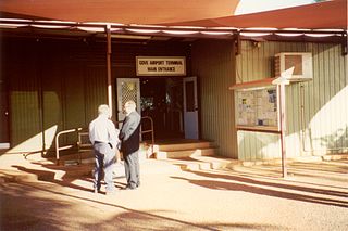
Gove Airport is on the Gove Peninsula in the Northern Territory of Australia. It services the mining town of Nhulunbuy and several Aboriginal communities including Yirrkala. The airport is located 5.8 nautical miles south southeast of the Nhulunbuy town centre, on Melville Road. It is operated by the Nhulunbuy Corporation.

Alice Springs Airport is an Australian regional airport 7 nautical miles south of Alice Springs, Northern Territory. The airport was notably involved in Australia's first domestic airline hijacking, and later a suicide attack by a former airline employee which claimed the lives of four others.

Christmas Island International Airport is an airport located on Christmas Island, a territory of Australia in the Indian Ocean. The island is located 2,600 km (1,600 mi) northwest of the Western Australian city of Perth, 500 km (310 mi) south of the Indonesian capital, Jakarta, and 975 km (606 mi) east-northeast of the Cocos (Keeling) Islands.

Cocos (Keeling) Islands Airport is an airport serving the Cocos (Keeling) Islands, a territory of Australia located in the Indian Ocean. The airport is on West Island, one of the South Keeling Islands and capital of the territory.
Groote Eylandt Airport is an airport serving Groote Eylandt, an island in the Gulf of Carpentaria in Northern Territory, Australia. The airport is operated by the Groote Eylandt Mining Co. and is located north of the community of Angurugu.
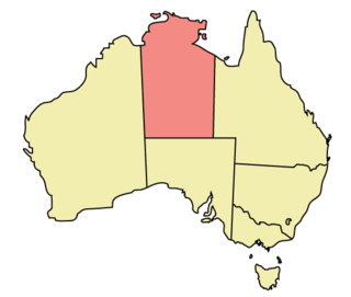
The Northern Territory (NT) occupies the north central part of the continent of Australia. The Northern Territory borders are to the west with Western Australia, the Western Australia border being near the 129° east longitude. The NT to the south with the South Australian border being the 26th parallel south latitude. To the east the NT with the Queensland border along the 138° east longitude.

Strauss Airfield was an airfield in the Northern Territory of Australia in the locality of Noonamah constructed between 19 March to 27 April 1942 during World War II. It was also known as 27 Mile Field or Humpty Doo Strip.
Pine Creek Airfield was an emergency landing ground at Pine Creek, Northern Territory, Australia during World War II.
Gould Airfield was an airfield south of Batchelor Airfield at Batchelor, Northern Territory, Australia during World War II.

Bathurst Island Airport is an airport located at Wurrumiyanga, on the southeast coast of Bathurst Island, in the Northern Territory of Australia.
The Ndjébbana language, also spelt Djeebbana and Ndjebanna and also known as Kunibidji, is a Burarran language spoken by the Gunavidji (Ndjebbana) people of North-central Arnhem Land in the Northern Territory of Australia.

Emkaytee Airfield, also known as MKT Airfield is a private airport in the Northern Territory of Australia located in the locality of Weddell, Northern Territory about 40 km (25 mi) south of the territory capital of Darwin City. The airfield has been operated by the Meyering family since 1980. Predominately used for recreational flying by ultralight aircraft, Emkaytee also provides flight training, aircraft maintenance and fuel supplies. The airfield has been used by the Australian Army, Royal Australian Air Force, customs and emergency services as a training and staging facility. Based on aircraft movements Emkaytee is the Northern Territory's second busiest after Darwin International Airport and provides an alternative destination for visiting light aircraft.
Borroloola Airport is an airport located approximately 1.5 km (0.93 mi) south of Borroloola in the Northern Territory, Australia.
Fly Tiwi is an Australian airline based in Darwin, Northern Territory, offering scheduled passenger services between the Northern Territory capital and communities located on the Tiwi, South Goulburn and Croker islands, as well as a number of remote Arnhem Land communities. The company is wholly owned by the Hardy Aviation group, Australia's largest general aviation company and was founded in 2008 in association with the Tiwi Land Council and now operates over 60 flights per week between 10 destinations.
