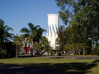
Biloela is a rural town and locality in Shire of Banana, Central Queensland, Australia. It is situated 120 kilometres (75 mi) inland from the port city of Gladstone at the junction of the Burnett and Dawson highways. Biloela is the administrative centre of Banana Shire, which has an area of 15,729 square kilometres (6,073 sq mi). In the 2016 census, Biloela had a population of 5,758 people.

Thargomindah is a rural town and locality in the Shire of Bulloo, Queensland, Australia. The town of Thargomindah is the administrative centre for the Shire of Bulloo. In the 2016 census, Thargomindah had a population of 270 people. It was founded on Wongkumara and Kalali territory.

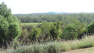
Banana is a small town and rural locality in the Shire of Banana, Central Queensland, Australia.

Sunshine Coast Airport is an Australian international airport located at the northern end of the Sunshine Coast and approximately 90 km (56 mi) north of centre of Brisbane, within South East Queensland agglomeration. It is the principal airport for the Sunshine Coast and is the only airport in the region capable of servicing jet aircraft operations.

Baralaba is a rural town and locality in the Shire of Banana in central Queensland, Australia. In the 2016 census, Baralaba had a population of 314 people.
Taroom is a town in the Shire of Banana and locality split between the Shire of Banana and the Western Downs Region in Queensland, Australia. At the 2016 census, Taroom had a population of 869 people.
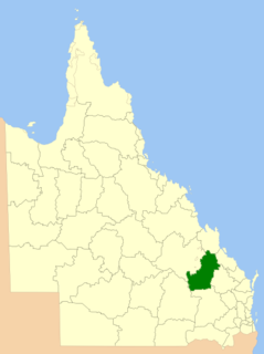
The Shire of Banana is a local government area located in the Capricorn region of Queensland, Australia, inland from the regional city of Gladstone. The shire was named after the first township in the region (Banana), which in turn was named for the burial site of a huge dun coloured bullock named 'Banana'. The council sits in the town of Biloela, which is the largest town in the Shire.

The Shire of Murweh is a local government area in the Maranoa district, which is part of South West Queensland, Australia. The administrative centre and largest town in the shire is Charleville. In June 2018, the Shire of Murweh had a population of 4,318.

The Shire of Hinchinbrook is a local government area in North Queensland, Queensland, Australia. The shire, administered from the town of Ingham, covers an area of 2,807 square kilometres (1,083.8 sq mi), and has existed since its creation on 11 November 1879 as one of 74 divisions around Queensland under the Divisional Boards Act 1879.
The City of Gladstone is a former local government area in central Queensland, Australia. It covered the urban locality of Gladstone and parts of the surrounding area.

Hungerford is an outback town in the Shire of Bulloo and a locality in the Shire of Bulloo and Shire of Paroo, South West Queensland, Australia. At the 2016 census, Hungerford and the surrounding area within Queensland had a population of 23. The locality of Hungerford on the New South Wales side of the border had a population of 15.

Evans Head Memorial Aerodrome is a heritage-listed airport in Evans Head, Richmond Valley Council, New South Wales. The airport is approximately 1 km (0.62 mi) north of the village. During World War II it was Royal Australian Air Force (RAAF) Station Evans Head supporting RAAF No 1 Bombing and Gunnery School (1BAGS) and subsequently the RAAF No 1 Air Observers School. At the height of operations there were three asphalt runways and one grass strip. Only a single asphalt strip is still in use by private aviation. It was added to the New South Wales State Heritage Register on 22 November 2002.
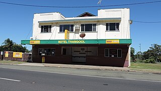
Thangool is a rural town and locality in the Shire of Banana, Queensland, Australia. In the 2016 census the locality of Thangool had a population of 741 people.
Chinchilla Airport is an airport serving Chinchilla, Queensland, Australia.
Mundoo is a rural town and locality in the Cassowary Coast Region, Queensland, Australia. In the 2016 census the locality of Mundoo had a population of 224 people.
Dirranbandi Airport is an airport serving Dirranbandi, Queensland, Australia.
Miles Airport or Aerodrome is an airport serving the small towns of Miles and Condamine, and surrounding rural residents in Queensland, Australia.
Link Airways, formerly known as Fly Corporate, is an Australian regional airline based at Brisbane Airport, Queensland.
Prospect is a rural locality in the Shire of Banana, Queensland, Australia. In the 2016 census Prospect had a population of 297 people.

Lawgi Dawes is a rural locality in the Shire of Banana, Queensland, Australia. In the 2016 census Lawgi Dawes had a population of 144 people. It contains the neighbourhood of Lawgi, a former town.


