
Cape York Peninsula is a peninsula located in Far North Queensland, Australia. It is the largest wilderness in northern Australia. The land is mostly flat and about half of the area is used for grazing cattle. The relatively undisturbed eucalyptus-wooded savannahs, tropical rainforests and other types of habitat are now recognised and preserved for their global environmental significance. Although much of the peninsula remains pristine, with a diverse repertoire of endemic flora and fauna, some of its wildlife may be threatened by industry and overgrazing as well as introduced species and weeds.
MacAir Airlines Pty Ltd was a regional airline based in Townsville, Queensland, Australia. It operated scheduled passenger services throughout Queensland from major regional locations, as well as regular and ad hoc charters for the minerals industry in Queensland. Its main operations base was Townsville Airport, with hubs at Cairns, Brisbane and Mount Isa.
Skytrans is an Australian owned and operated airline and air charter business based in Cairns. The airline operates RPT and charter services from Cairns, Horn Island, and Brisbane. After being placed in administration in January 2015, Skytrans returned to the skies on 31 March 2015.

Far North Queensland (FNQ) is the northernmost part of the Australian state of Queensland. Its largest city is Cairns and it is dominated geographically by Cape York Peninsula, which stretches north to the Torres Strait, and west to the Gulf Country. The waters of Torres Strait include the only international border in the area contiguous with the Australian mainland, between Australia and Papua New Guinea.

Kowanyama is a town and coastal locality in the Aboriginal Shire of Kowanyama, Queensland, Australia.

Pormpuraaw is a coastal town and a locality in the Aboriginal Shire of Pormpuraaw, Queensland, Australia. Pormpuraaw is an Aboriginal community situated on the west coast of Cape York Peninsula approximately halfway between Karumba and Weipa on the Edward River. It is 650 kilometres (400 mi) by road from Cairns. Pormpuraaw currently has a 4-man police station.
Yir-Yoront was a Paman language spoken in two settlements, Kowanyama and Pormpuraaw on the southwestern part of the Cape York Peninsula, Queensland in Australia, by the Yir-Yoront people. In 1991 only 15 speakers remained, with the rest of the Yir-Yoront people speaking English or even Kuuk Thaayorre as many speakers of Yir-Yoront apparently are using Kuuk Thaayorre in daily conversation. At present it is thought to be extinct. There are two sister dialects, Yir-Yoront proper and Yirrk-Thangalkl, which are very close. The shared name Yir is sometimes used for both taken together.
The Shire of Carpentaria is a local government area in Far North Queensland, Australia on the Gulf of Carpentaria, for which it is named.

The Shire of Cook is a local government area in Far North Queensland, Australia. The Shire covers most of the eastern and central parts of Cape York Peninsula, the most northerly section of the Australian mainland.
There are two library services operating in Australia that have adopted the appellation "knowledge centre" in relation to the delivery of library services for Indigenous Australian clients. The Northern Territory Library first developed the Indigenous Knowledge Centre model of service and later changed this to Library and Knowledge Centre. The State Library of Queensland continues to use the title Indigenous Knowledge Centre.
The Edward River is a river in Far North Queensland, Australia.

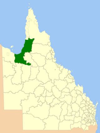
The Aboriginal Shire of Pormpuraaw is a special local government area which is located on western Cape York Peninsula in Queensland, Australia. It is managed under a Deed of Grant in Trust under the Local Government Act 2004.
The Thaayorre, or Kuuk Thaayore, are an Australian people living on the southwestern part of the Cape York Peninsula, Queensland in Australia, primarily in the settlement Pormpuraaw, having its foundation in the Edward River Mission.
Kuuk Yak, or the snake language, if translated literally, is an extinct Paman language which was spoken on the Cape York Peninsula of Queensland, Australia.

Hinterland Aviation is a regional airline and charter company based at Cairns Airport in Queensland, Australia. The airline operates scheduled flights from Cairns Airport and Townsville Airport.
Edward River is a rural locality in the Shire of Cook, Queensland, Australia. In the 2016 census Edward River had a population of 0 people.
Rebel FM is an Active rock-formatted radio station, based in the Gold Coast suburb of Helensvale, Queensland, and broadcasting across regional and rural areas of Queensland and New South Wales. First broadcast as SUN FM in 1996, it is owned and operated by Rebel Media, which also operates The Breeze.
The Coleman River is a river on the Cape York Peninsula in Far North Queensland, Australia.

Severe Tropical Cyclone Nora was a strong tropical cyclone that affected Far North Queensland and the northeastern Northern Territory during March 2018. The ninth named storm and third severe tropical cyclone of the 2017–18 Australian region cyclone season, Nora developed from a tropical low which formed near the Torres Strait on 19 March. The system initially moved quickly to the west-northwest, and then began tracking slowly southwestwards over the Arafura Sea while gradually developing. A turn to the east on 22 March brought the tropical low into a favourable environment for strengthening, and the system reached tropical cyclone intensity later that day. Nora then underwent a period of rapid intensification as it moved southeastwards into the Gulf of Carpentaria. The storm peaked on 23 March as a high-end Category 3 severe tropical cyclone with sustained winds of 155 km/h (96 mph) and a minimum barometric pressure of 958 hPa (28.29 inHg). Nora made landfall north of Pormpuraaw at about 13:00 UTC on 24 March as a minimal Category 3 system. Nora weakened steadily as it tracked southwards along the coast, and was downgraded to a tropical low the following day. Nora's remnants meandered over land for several days before moving back over the Gulf of Carpentaria and dissipating on 28 March.
