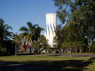
Biloela is a rural town and locality in the Shire of Banana, Central Queensland, Australia. It is situated 120 kilometres (75 mi) inland from the port city of Gladstone at the junction of the Burnett and Dawson highways. Biloela is the administrative centre of Banana Shire, which has an area of 15,729 square kilometres (6,073 sq mi). In the 2021 census, the locality of Biloela had a population of 5,692 people.

Banana is a rural town and locality in the Shire of Banana, Queensland, Australia. In the 2016 census, the locality of Banana had a population of 356 people.

The Dawson Highway is a state highway in Queensland, Australia. It runs for 405 kilometres (252 mi) between Gladstone and Springsure where it terminates. From Gladstone to Rolleston it is signed as State Route 60, and then A7 onwards to Springsure. It continues west for another 247 kilometres (153 mi) as Dawson Developmental Road to Tambo on the Landsborough Highway. North of Springsure, A7 becomes the Gregory Highway.

The Burnett Highway is an inland rural highway located in Queensland, Australia. The highway runs from its junction with the Bruce Highway at Gracemere, just south of Rockhampton, to the D'Aguilar Highway in Nanango. Its length is approximately 542 kilometres. The highway takes its name from the Burnett River, which it crosses in Gayndah. The Burnett Highway provides the most direct link between the northern end of the New England Highway and Rockhampton. It is designated as a State Strategic Road by the Queensland Government.

Hervey Bay Airport is the main airport for the city of Hervey Bay, Queensland, Australia and the Fraser Coast region which incorporates the nearby city of Maryborough.
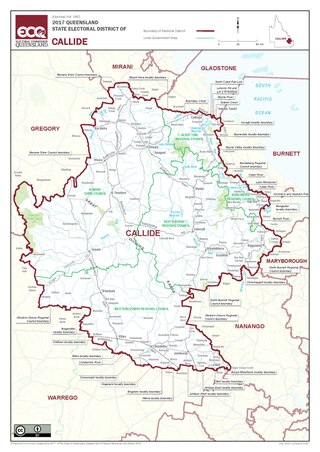
Callide is an electoral division in Queensland, Australia.

The Shire of Banana is a local government area located in the Capricorn region of Queensland, Australia, inland from the regional city of Gladstone. The shire was named after the first township in the region (Banana), which in turn was named for the burial site of a huge dun coloured bullock named 'Banana'. The council sits in the town of Biloela, which is the largest town in the Shire.

HMAS Biloela was a fleet collier operated by the Royal Australian Navy (RAN) from 1920 to 1927.

Rannes is a rural town in the west of the locality of Goovigen in the Shire of Banana, Queensland, Australia.
The Callide Valley railway line ran from Rannes to Lawgi in Queensland, Australia. The Callide Valley lies to the south-west of Rockhampton in Central Queensland.
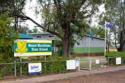
Mount Murchison is a rural locality in the Shire of Banana, Queensland, Australia.
Harrami is a rural locality in the North Burnett Region, Queensland, Australia. In the 2021 census, Harrami had a population of 22 people.
Callide is a rural town and locality in the Shire of Banana, Queensland, Australia. In the 2016 census, the locality of Callide had a population of 86 people.
Greycliffe is a rural locality in the Shire of Banana, Queensland, Australia. In the 2016 census, Greycliffe had a population of 22 people.
Valentine Plains is a rural locality in the Shire of Banana, Queensland, Australia. In the 2016 census, Valentine Plains had a population of 394 people.
Dakenba is a rural locality in the Shire of Banana, Queensland, Australia. In the 2016 census, Dakenba had a population of 116 people.
The Murugappan family, also known as the Nadesalingam family, consists of Nadesalingam Murugappan (Nades), his wife Kokilapathmapriya Nadesalingam (Priya) and their two daughters. They are Sri Lankan Tamils seeking asylum in Australia. The couple married in Australia after arriving separately on people smuggler boats; their children were subsequently born in Australia. Until their detention by the Australian Border Force in March 2018, the family, which was resident in the central Queensland town of Biloela, was consequently referred to as the Biloela family by some media. The cause of the couple and their children has been supported by some residents of Biloela as well as asylum-seeker advocates. The Australian federal government of the time assessed them not to be refugees and, consequently, detained and sought to remove them.
Orange Creek is a rural locality in the Shire of Banana, Queensland, Australia. In the 2021 census, Orange Creek had a population of 197 people.
The following radio stations broadcast on AM frequency 666 kHz:
