
Barcaldine is a rural town and locality in the Barcaldine Region in Queensland, Australia. This is the administrative centre of the Barcaldine Region. Barcaldine played a major role in the Australian labour movement.
Aramac is a rural town and locality in the Barcaldine Region, Queensland, Australia. In the 2016 census, Aramac had a population of 299 people.

Muttaburra is an outback town and locality in the Barcaldine Region, Queensland, Australia. Muttaburra was the discovery site of the Muttaburrasaurus, one of Australia's most famous dinosaurs.

Jericho is a rural town and locality in the Barcaldine Region, Queensland, Australia. In the 2021 census, the locality of Jericho had a population of 229 people.

The Tree of Knowledge was a heritage-listed tree in Oak Street, Barcaldine, Barcaldine Region, Queensland, Australia, that was poisoned and killed in 2006. It was a 200-year-old Corymbia aparrerinja ghost gum. It was added to the Queensland Heritage Register on 21 October 1992.

The Shire of Aramac was a local government area located in central Queensland about 1,100 kilometres (684 mi) north west of the state capital, Brisbane, between the towns of Barcaldine and Winton. It covered an area of 23,364.1 square kilometres (9,020.9 sq mi), and existed as a local government entity from 1879 until 2008, when it amalgamated with the Shires of Barcaldine and Jericho to form the Barcaldine Region.

The Shire of Barcaldine was a local government area located in central Queensland and headquartered in the town of Barcaldine. It covered an area of 8,448.4 square kilometres (3,261.9 sq mi), and existed as a local government entity from 1892 until 2008, when it amalgamated with the Shires of Aramac and Jericho to form the Barcaldine Region.

The Shire of Jericho was a local government area in central Queensland between the towns of Barcaldine and Emerald. Administered from the town of Alpha, the Shire covered an area of 21,864.9 square kilometres (8,442.1 sq mi), and existed as a local government entity from 1916 until 2008, when it amalgamated with the Shires of Aramac and Barcaldine to form the Barcaldine Region.

The Barcaldine Region is a local government area in Central West Queensland, Australia. Established in 2008, it was preceded by three previous local government areas which had existed for over a century.
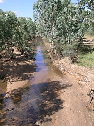
The Alice River in central Queensland, Australia rises on the western slopes of the Great Dividing Range. The river bisects the Shire of Barcaldine, flowing in a south-westerly direction towards Isisford and its confluence with the Barcoo River. The town of Barcaldine is located on the Alice River. The Alice River's tributaries include Jordan Creek and Lagoon Creek. The Alice River is often dry, except after the annual summer rains.

Central West Queensland is a remote region in the Australian state of Queensland which covers 396,650.2 km2. The region lies to the north of South West Queensland and south of the Gulf Country. It has a population of approximately 12,387 people.
Ibis is a former rural locality in the Barcaldine Region, Queensland, Australia. In the 2016 census, Ibis had a population of 4 people.
Grant is a former rural locality in the Barcaldine Region, Queensland, Australia. In the 2016 census, Grant had a population of 11 people.
Home Creek is a former rural locality in the Barcaldine Region, Queensland, Australia. In the 2016 census, Home Creek had a population of 24 people.

Saltern Creek is a former rural locality in the Barcaldine Region, Queensland, Australia. In the 2016 census, Saltern Creek had a population of 12 people.
Tara Station is a former rural locality in the Barcaldine Region, Queensland, Australia. In the 2016 census, Tara Station had a population of 10 people.
Garfield is a former rural locality in the Barcaldine Region, Queensland, Australia. In the 2016 census, Garfield had a population of 37 people.
Sedgeford is a former rural locality in the Barcaldine Region, Queensland, Australia. In the 2016 census, Sedgeford had a population of 0 people.

