
Queensland is a state situated in northeastern Australia, and is the second-largest and third-most populous of the Australian states. It is bordered by the Northern Territory, South Australia and New South Wales to the west, south-west and south respectively. To the east, Queensland is bordered by the Coral Sea and the Pacific Ocean; to its north is the Torres Strait, separating the Australian mainland from Papua New Guinea, and the Gulf of Carpentaria to the north-west. With an area of 1,852,642 square kilometres (715,309 sq mi), Queensland is the world's sixth-largest sub-national entity; it is larger than all but 15 countries. Due to its size, Queensland's geographical features and climates are diverse, including tropical rainforests, rivers, coral reefs, mountain ranges and sandy beaches in its tropical and sub-tropical coastal regions, as well as deserts and savanna in the semi-arid and desert climatic regions of its interior.
Anthony Ronald Yary is an American former professional football offensive tackle who played in the National Football League (NFL), primarily for the Minnesota Vikings, and also for the Los Angeles Rams. He was elected to the College Football Hall of Fame in 1987 and the Pro Football Hall of Fame in 2001. Yary gave credit for his Pro Football Hall of Fame induction to his former coaches, John Ashton John McKay (college) and Bud Grant (professional). He also praised his position coaches Marv Goux, Dave Levy, John Michaels and Jerry Burns.

Cairns Airport is an international airport in Cairns, Queensland, Australia. Formerly operated by the Cairns Port Authority, the airport was sold by the Queensland Government in December 2008 to a private consortium. It is the seventh busiest airport in Australia. The airport is located 2.3 nautical miles north northwest of Cairns or 7 kilometres (4.3 mi) north of the Cairns central business district, in the suburb of Aeroglen. The airport lies between Mount Whitfield to the west and Trinity Bay to the east.

Gold Coast Airport is an international Australian airport located at the southern end of the Gold Coast and approximately 90 km (56 mi) south of Brisbane, within the South East Queensland agglomeration. The entrance to the airport is situated in the suburb of Bilinga near Coolangatta. The main runway itself cuts through the state borders of Queensland and New South Wales. During summer, these states are in two different time zones. The Gold Coast Airport operates on Queensland Time.

South East Queensland (SEQ) is a bio-geographical, metropolitan, political and administrative region of the state of Queensland in Australia, with a population of approximately 3.8 million people out of the state's population of 5.1 million. The area covered by South East Queensland varies, depending on the definition of the region, though it tends to include Queensland's three largest cities: the capital city Brisbane; the Gold Coast; and the Sunshine Coast. Its most common use is for political purposes, and covers 35,248 square kilometres (13,609 sq mi) and incorporates 11 local government areas, extending 240 kilometres (150 mi) from Noosa in the north to the Gold Coast and New South Wales border in the south, and 140 kilometres (87 mi) west to Toowoomba. It is the third largest urban area in Australia by population.

Mackay Airport located in South Mackay, Queensland, Australia is a major Australian regional airport that services the city of Mackay, with flights to the cities of Brisbane, Rockhampton, Townsville, Hamilton Island, Cairns, Sunshine Coast and Melbourne. In the year ending 30 June 2012, the airport handled 969,900 passengers making it the 14th busiest airport in Australia.

Innamincka, formerly Hopetoun, is a township and locality in north-east South Australia. By air it is 820 kilometres north-east of the state capital, Adelaide, and 365 kilometres north-east of the closest town, Lyndhurst. It is 66 kilometres north-east of the Moomba Gas Refinery. The town lies within the Innamincka Regional Reserve and is surrounded by the Strzelecki Desert to the south and the Sturt Stony Desert to the north. It is linked by road to Lyndhurst via the Strzelecki Track, to the Birdsville Developmental Road via Cordillo Downs Road and Arrabury Road, and the Walkers Crossing Track to the Birdsville Track. The Walkers Crossing Track is closed in summer and only traversable in dry weather. The township is situated along the Cooper Creek, a part of the Lake Eyre basin.
Mount Isa Airport is an airport serving the western Queensland city of Mount Isa, Australia. It is served by a variety of scheduled regional airlines, with flights to Brisbane, Townsville and Cairns as well as several other regional centres.

Birdsville Airport is an airport serving Birdsville, Queensland, Australia. During the Birdsville Races weekend each September, as many as 200 light aircraft visit the airport, with aviators permitted to camp under the wings of their planes. The Channel Mail Run, the world's longest mail run operates between Port Augusta, South Australia and Birdsville, stopping in the town to collect mail for the remote Queensland cattle stations of Glengyle and Durrie.
Boigu Island Airport is an airport serving Boigu Island in Queensland, Australia. It was officially opened as the Charlie Gibuma Memorial Airstrip on 26 July 1981 by Hon. Ken Tomkins, then Queensland Minister for Aboriginal and Island Affairs. The airport is operated by the Torres Strait Islands Regional Council.
Cunnamulla Airport is an airport in Cunnamulla, Queensland, Australia. The airport is 4 nautical miles west northwest from the town.
Mabuiag Island Airport is an airport on Mabuiag Island, Queensland, Australia. The airport received $52,422 in funds for security updates in 2006. It has Australia's shortest runway in commercial service.
Quilpie Airport is an airport serving Quilpie, Queensland, Australia. It is located 1 nautical mile west of Quilpie and operated by the Quilpie Shire Council. The airport received $242,666 for security upgrades from the Australian Government in 2006.
Windorah Airport is an airport serving Windorah, Queensland, Australia. It is operated by the Barcoo Shire Council. The airport received $183,578 in funds for security upgrades from the Australian Government in 2006.

Elections were held in the Australian state of Queensland on 2 April 1938 to elect the 62 members of the state's Legislative Assembly. The Labor government of Premier William Forgan Smith was seeking a third term in office. During the previous term, the Country and United Australia parties had emerged from the united Country and Progressive National Party, which had represented conservative forces for over a decade.

Tanbar is an outback locality in the Shire of Barcoo, Queensland, Australia. It is on the corner of Queensland's southern and western border with South Australia. In the 2016 census Tanbar had a population of 3 people.
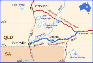
The Birdsville Developmental Road is a mostly unsealed road in south-west Queensland that branches off the Diamantina Developmental Road at a point 103 kilometres (64 mi) west of Windorah and runs to Birdsville. Its length is 273 kilometres (170 mi). The road crosses a major channel of the Diamantina River just before reaching Birdsville. It links with Cordillo Downs road and Arrabury Road, both of which lead to the South Australian town of Innamincka.
The Ngurawola were an indigenous Australian people of the state of Queensland.

