
Blackdown Tableland is a national park in the Central Highlands Region, Queensland, Australia.

Minerva Hills is a national park in Central Queensland, Australia, 626 km northwest of Brisbane. Lookouts within the national park overlook the town of Springsure. The park features a rugged landscape with volcanic peaks, sheltered gorges, sheer cliffs, open woodlands and dry rainforest.

Central Queensland is an ambiguous geographical division of Queensland that centres on the eastern coast, around the Tropic of Capricorn. Its major regional centre is Rockhampton. The region extends from the Capricorn Coast west to the Central Highlands at Emerald, north to the Mackay Regional Council southern boundary, and south to Gladstone. The region is also known as Capricornia. It is one of Australia's main coal exporting regions.
Rolleston is a small town and locality in the Central Highlands Region, Queensland, Australia.

The Dawson Highway is a state highway in Queensland, Australia. It runs for 405 km between Gladstone and Springsure where it terminates. From Gladstone to Rolleston it is signed as State Route 60, and then A7 onwards to Springsure. It continues west for another 247 km as Dawson Developmental Road to Tambo on the Landsborough Highway. North of Springsure, A7 becomes the Gregory Highway.
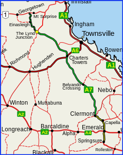
The Gregory Highway is a state highway in Queensland that serves the major coal-mining centres of Central Queensland. The highway was named after Augustus Gregory, an early explorer.
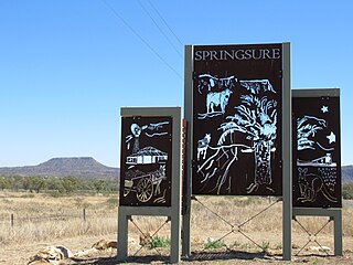
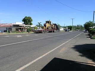
Springsure is a town and a locality in the Central Highlands Region, Queensland, Australia. It is 66 kilometres (41 mi) south of Emerald on the Gregory Highway. It is the southern terminus of the Gregory Highway and the northern terminus of the Dawson Highway. It is 765 kilometres (475 mi) northwest of Brisbane. In the 2016 census, Springsure had a population of 1,103 people.

Expedition Range is a mountain range within the Central Highlands sandstone region of Queensland, Australia. Robinson Creek cuts a 100 metres deep gorge through sandstone clifflines. Many spectacular side gorges add to the appeal of the area, which is included in the Expedition National Park.

The Shire of Bauhinia was a local government area in Central Queensland, Queensland, Australia. The Shire, administered from the town of Springsure, covered an area of 23,649.6 square kilometres (9,131.2 sq mi), and existed as a local government entity from 1879 until 2008, when it was amalgamated with the Shires of Duaringa, Emerald and Peak Downs to form the Central Highlands Region.

The Roman Catholic Diocese of Rockhampton is a suffragan Latin Church diocese of the Archdiocese of Brisbane, erected in 1882, covering Central Queensland, Australia.

Emerald Airport is an airport serving Emerald, a town located in the Central Highlands district of Queensland, Australia. It is located 6 km (4 mi) south of the Emerald town centre, on Springsure Road. The airport is operated by the Central Highlands Regional Council.
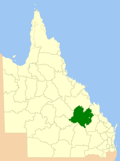
Central Highlands Region is a local government area in Queensland, Australia.
Leichhardt was an electoral district of the Legislative Assembly in the Australian state of Queensland from 1860 to 1932.

The Comet River is a river located in Central Queensland, Australia.

Grevillea sessilis is a shrub which is endemic to Queensland in Australia.
Springsure was a Legislative Assembly electorate in the state of Queensland.

John Denis (Jack) Fryer (1895–1923) was a soldier and a student of the University of Queensland in Brisbane, Queensland, Australia. His untimely death resulted in the establishment of the Fryer Library at the University.
Nandowrie is a rural locality in the Central Highlands Region, Queensland, Australia. In the 2016 census, Nandowrie had a population of 45 people.
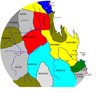
The Gayiri, people, also spelt or known as Kairi, Kararya, Kari, Khararya and Kaira, Bimurraburra, Gahrarja, Gara Gara, Ara Ara, and Kara Kara, are an Aboriginal Australian people of the state of Queensland.
Cona Creek is a locality in the Central Highlands Region, Queensland, Australia. In the 2016 census, Cona Creek had a population of 83 people.
