Cloncurry Airport

Last updated

Cloncurry Airport
Summary
Airport typePublic
Operator Cloncurry Shire Council
Location Cloncurry, Queensland
Elevation  AMSL 616 ft / 188 m
Coordinates 20°39′55″S140°30′23″E / 20.66528°S 140.50639°E / -20.66528; 140.50639 Coordinates: 20°39′55″S140°30′23″E / 20.66528°S 140.50639°E / -20.66528; 140.50639
Map
Australia Queensland location map.svg
Airplane silhouette.svg
YCCY
Location in Queensland
Runways
Direction LengthSurface
mft
06/241,1573,796 Asphalt
12/302,0006,562 Asphalt
Sources: Australian AIP and aerodrome chart [1]

Cloncurry Airport( IATA : CNJ, ICAO : YCCY) is an airport in Cloncurry, Queensland, Australia.

Contents

History

QANTAS biplane at Cloncurry, 1923 Airco de Havilland DH.9C G-AUEF was acquired by QANTAS in 1923 for the Charleville - Cloncurry route. Pilot, Captain G. Matthews is on the left and Mr. A. N. Templeton is on the right. StateLibQld 1 114328 QANTAS biplane at Cloncurry, 1923.jpg
QANTAS biplane at Cloncurry, 1923 Airco de Havilland DH.9C G-AUEF was acquired by QANTAS in 1923 for the Charleville - Cloncurry route. Pilot, Captain G. Matthews is on the left and Mr. A. N. Templeton is on the right.

Cloncurry Airport has been the focal point for many of Australia's greatest innovations. Cloncurry was involved with the beginnings of QANTAS, and the original QANTAS hangar is still in use at the aerodrome, where "Queensland and Northern Territory Aerial Service" is still displayed above the hangar door.

The Royal Flying Doctor Service was founded there in 1928, now recognised the world over. The airport was also on route for early planes coming from overseas and a stopping place for contestants in the great air races of 1919 and 1934.

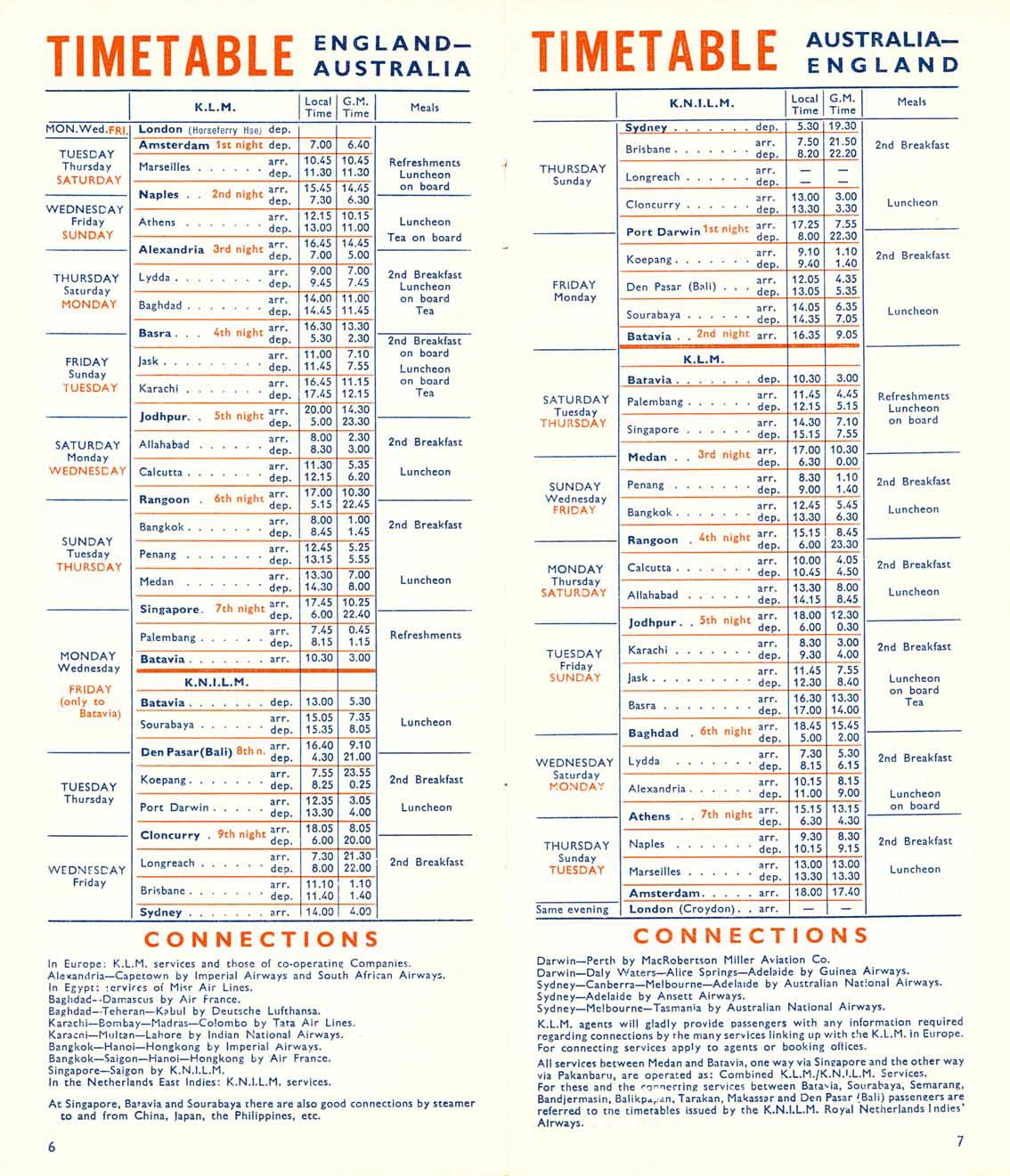
In the late 1930s (as early as 1938, as late as 1941), the KNILM service from Batavia (Jakarta) to Sydney, connecting at Batavia from Amsterdam on KLM, called at Cloncurry. On the way South, passengers spent the night, while on the way North, they had a luncheon in Cloncurry. [2]


In early 2022, Horizon Airways established a base in Cloncurry providing flight training for all initial and advanced training, as well as fixed wing charter flight services.

World War II

Due to the strategic importance of Cloncurry aerodrome on the main Darwin–Sydney air route, the Royal Australian Air Force expanded the aerodrome during World War II. Intended to be a major airbase should the Empire of Japan have occupied New Guinea and Papua.

During the Second World War, Cloncurry Airport was the site of a major United States Army Air Forces air base in 1942. As the war moved north, the USAAF units located north to forward bases.

List of wartime military units based at Cloncurry Aerodrome

HQ 19th Bomb Group assigned to Essendon Airport, Melbourne, Victoria
28th Bombardment Squadron, (28 March-5 May 1942)
Detachment operated from: Perth Airport, Perth, Western Australia, (28 March-18 May 1942)
30th Bombardment Squadron, (24 March-13 May 1942)
93d Bombardment Squadron, (29 March-18 May 1942)

Airlines and destinations

Aeroplane fuselage under construction, Cloncurry, ca. 1927 Brims Brothers Plywood Factory made the plywood which was used for construction of the aeroplane bodies by Qantas airways in the 1920s. StateLibQld 1 121576 Aeroplane fuselage under construction, Cloncurry, ca. 1927.jpg
Aeroplane fuselage under construction, Cloncurry, ca. 1927 Brims Brothers Plywood Factory made the plywood which was used for construction of the aeroplane bodies by Qantas airways in the 1920s.
AirlinesDestinations
Alliance Airlines Brisbane, Townsville
Mining charter: Cairns
QantasLink Mount Isa, Townsville

See also

Related Research Articles

<span class="mw-page-title-main">Archerfield Airport</span> Municipal airport serving Brisbane, Queensland, Australia

Archerfield Airport is a leased federal airport located in Archerfield, 11–12 km (6.8–7.5 mi) to the south of Brisbane, Queensland, Australia. For some time it was the primary airport in Brisbane. During World War II it was used as a Royal Australian Air Force station. Airport traffic peaked in the 1980s. In December 2010, a development plan was released for public comment which included a new parallel runway.

<span class="mw-page-title-main">RAAF Base Darwin</span>

RAAF Base Darwin is a Royal Australian Air Force (RAAF) military air base located in the city of Darwin, in the Northern Territory, Australia. The base shares its runway with Darwin International Airport, for civil aviation purposes. The heritage-listed RAAF Base Darwin is a forward operating base with year-round activity with approximately 400 personnel.

<span class="mw-page-title-main">RAAF Base Townsville</span>

RAAF Base Townsville is a Royal Australian Air Force (RAAF) air base located in Garbutt, 2 nautical miles west of Townsville in Queensland, Australia. It is the headquarters for No. 1 Wing Australian Air Force Cadets and, along with Lavarack Barracks, establishes Townsville as a key military centre. The base's airfield is shared with the Townsville Airport.

<span class="mw-page-title-main">Bundaberg Airport</span> Airport in Queensland, Australia

Bundaberg Airport is a regional airport serving Bundaberg, a city in the Australian state of Queensland. It is located 2.5 nautical miles southwest of the city centre, on North Childers Road and Takalvan Street. The airport is owned and operated by the Bundaberg Regional Council. It is also known as Bundaberg Regional Airport.

<span class="mw-page-title-main">Charleville Airport</span> Airport in Queensland, Australia

Charleville Airport is an airport located 1 nautical mile southwest of Charleville, a town in the state of Queensland in Australia.

Geraldton Airport is an airport located 6 nautical miles east of Geraldton, Western Australia, in Moonyoonooka along the Geraldton – Mount Magnet Road. On average, from 2013 to 2017, more than 120,000 passengers used the airport annually.

Parap Airfield was the civilian aerodrome of Darwin, Northern Territory, in Australia between 1919 and 1946. Located in the coastal suburb of Parap, it was also known as Darwin Aerodrome and Ross Smith Aerodrome.

<span class="mw-page-title-main">Batchelor Airfield</span> Australian non-commercial airport

Batchelor Airfield, is an airport located south of Batchelor, Northern Territory, Australia. The airport currently has no commercial air services; however, it is utilised by the Northern Australian Gliding Club and the Alice Springs Aero Club as a flight training base.

The Daly Waters Airfield, also RAAF Base Daly Waters, is a former commercial and sporadically-used military airfield located at Daly Waters, Northern Territory, Australia. As Australia's first international airfield, Daly Waters was used throughout the 1920s and 1930s as a stop over for commercial airlines operating on the domestic route to Western Australia and international carriers flying from Australia into south-east Asia. During World War II, the airbase was used by the Royal Australian Air Force (RAAF) and the United States Army Air Force to undertake combat operations against the Japanese in New Guinea, the Dutch East Indies and the islands to Australia's north. Following the war, the airbase was used commercially again up until the 1970s when the airfield was sporadically-used by the RAAF.

<span class="mw-page-title-main">Fenton Airfield</span> World War II airfield

Fenton Airfield was a World War II military airfield in the Northern Territory of Australia located at Tipperary Station in what is now the locality of Douglas-Daly and named after flight lieutenant Clyde Fenton.

<span class="mw-page-title-main">Eagle Farm Airport</span> Former airport in Brisbane, Queensland, Australia

Eagle Farm Airport(IATA: BNE, ICAO: YBBN) was a small airport located 6 km (3.7 mi) north-east of Brisbane in the suburb of Eagle Farm, Queensland, Australia.

Bohle River Aerodrome was an aerodrome located 12.66 km (7.87 mi) west of Townsville, Queensland, Australia.

<span class="mw-page-title-main">Breddan Aerodrome</span> Historic site in Queensland, Australia

Breddan Aerodrome is a heritage-listed abandoned aerodrome at Gregory Developmental Road, Breddan, Charters Towers Region, Queensland, Australia. It is located 15 kilometres (9.3 mi) north of Charters Towers. It was built from 1942 to 1943 by Allied Works Council and Queensland Main Roads Commission. The airfield was constructed for the USAAF 38th Bomb Group in August 1942 as a satellite field for Charters Towers Airport, and later used by the Royal Australian Air Force (RAAF) during World War II as a maintenance base. Consisting of two runways, the airfield was abandoned after 1948. Today, the remains of the airfield consist of some deteriorating runways, taxiways and hardstands, mostly being reclaimed by grassland and shrub. No buildings have survived. It is also known as Breddan Airfield and Breddan WWII Aircraft Maintenance, Repair and Salvage Depot. It was added to the Queensland Heritage Register on 16 April 2010.

<span class="mw-page-title-main">United States Army Air Forces in Australia</span>

During World War II, the United States Army Air Forces established a series of airfields in Australia for the collective defense of the country, as well as for conducting offensive operations against the Imperial Japanese Army and Navy. From these airports and airfields in Australia, the Fifth Air Force was able to regroup, re-equip and begin offensive operations against the Empire of Japan after the disasters in the Philippines and Dutch East Indies during 1942.

<span class="mw-page-title-main">Charters Towers Airport</span> Airport in Charters Towers, Queensland

Charters Towers Airport is an airport located in Columbia, Charters Towers, Queensland, Australia, 2.9 nautical miles north of the Charters Towers CBD.

Petrie Airfield was a World War II military airfield located just to the south of the North Pine River in what is now Lawnton, Queensland, Australia. After the war, the airfield was dismantled and the area is now part of the urban area of Petrie-Strathpine.

<span class="mw-page-title-main">Mareeba Airfield</span> Airport in Queensland, Australia

Mareeba Airfield is an airfield located 4.3 nautical miles south of Mareeba, Queensland, Australia. Built in 1942 as a US Army Air Force base during World War II, the airfield had two runways, with a complement of taxiways, hardstands and a containment area. After the war, much of the airfield reverted to agricultural use, while the southern runway remains as an active airfield.

<span class="mw-page-title-main">435th Bombardment Squadron</span> Military unit

The 435th Bombardment Squadron, also known as the "Kangaroo" Squadron, is an inactive United States Air Force unit. It was last assigned to the Eighth Air Force 333d Bombardment Group, based at Kadena Air Base, Okinawa. It was inactivated on 28 May 1946.

<span class="mw-page-title-main">RAAF Base Amberley</span> Royal Australian Air Force base southwest of Ipswich, Queensland

RAAF Base Amberley is a Royal Australian Air Force (RAAF) military airbase located 8 km (5.0 mi) southwest of Ipswich, Queensland in Australia and 50 km (31 mi) southwest of Brisbane CBD. It is currently home to No. 1 Squadron, No. 6 Squadron, No. 33 Squadron, No. 35 Squadron and No. 36 Squadron. Amberley is also home to Army units making up the 9th Force Support Battalion. Located on 1,600 hectares, RAAF Amberley is the largest operational base in the RAAF, employing over 5,000 uniformed and civilian personnel. There are a variety of other formations on the base such as training colleges and maintenance areas. Amberley's largest squadron in terms of personnel is No. 382 Expeditionary Combat Support Squadron RAAF (ECSS) providing both garrison and deployed combat support. Amberley was one of only two airfields in Australia that were listed as a Transoceanic Abort (TOA) landing site for the Space Shuttle. Amberley is currently undergoing a A$64 million dollar re-development program. The RAAF has plans to have Amberley operating as its "superbase" with flights of F/A-18F Super Hornets, KC-30A, C-17 Globemaster and the C-27J Spartan.

<span class="mw-page-title-main">North-Western Area Command (RAAF)</span> Royal Australian Air Force command

North-Western Area Command was one of several geographically based commands raised by the Royal Australian Air Force (RAAF) during World War II. Its wartime sphere of operations included the Northern Territory, adjacent portions of Queensland and Western Australia, and the Dutch East Indies. The command was formed in January 1942, following the outbreak of the Pacific War, from the western part of Northern Area Command, which had covered all of northern Australia and Papua. Headquartered at Darwin, North-Western Area Command was initially responsible for air defence, aerial reconnaissance and protection of the sea lanes within its boundaries.

References

  1. YCCY – Cloncurry  (PDF). AIP En Route Supplement from Airservices Australia , effective 2022-09-22, Aeronautical Chart Archived 25 March 2012 at the Wayback Machine
  2. "KNILM Timetable". airline timetable images. Retrieved 31 December 2021.

PD-icon.svg This article incorporates public domain material from the Air Force Historical Research Agency.