
The Burnett River is a river located in the Wide Bay–Burnett and Central Queensland regions of Queensland, Australia.

The Burnett Highway is an inland rural highway located in Queensland, Australia. The highway runs between its junction with the Bruce Highway just south of Rockhampton, and Nanango. Its length is approximately 542 kilometres. The highway takes its name from the Burnett River, which it crosses in Gayndah. The Burnett Highway provides the most direct link between the northern end of the New England Highway and Rockhampton. It is designated as a State Strategic Road by the Queensland Government.
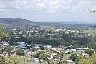
Gayndah is a town and locality in the North Burnett Region, Queensland, Australia. In the 2016 census, Gayndah had a population of 1,981 people. It is the administrative centre for the North Burnett Region.
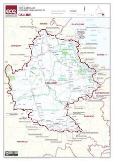
Callide is an electoral division in Queensland, Australia.

The Shire of Gayndah was a local government area located in the northern catchment of the Burnett River, Queensland, Australia. The shire covered an area of 2,709.3 square kilometres (1,046.1 sq mi), and existed as a local government area from 1866 until 2008, when it amalgamated with several other shires to form the North Burnett Region.
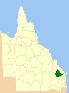
The North Burnett Region is a local government area in Queensland, Australia in the northern catchment of the Burnett River. Established in 2008, it was preceded by several previous local government areas with histories extending back to the early 1900s.

Wuruma Dam was constructed across the Nogo River in the upper Burnett River Catchment for irrigation & town water supply for Eidsvold, Mundubbera and Gayndah.
The Mungar Junction to Monto railway line is a 267 kilometre railway in Queensland, Australia. Progressively opened in eleven stages between 1889 and 1928 the line branched from the North Coast line at Mungar Junction a short distance west of Maryborough and followed a westerly route towards Biggenden and Gayndah before turning north via Mundubbera and Eidsvold to Monto. It is also known as the Gayndah Monto Branch Railway.

Wide Bay–Burnett is a region of the Australian state of Queensland, located between 170–400 km (110–250 mi) north of the state capital, Brisbane. The area's population growth has exceeded the state average over the past 20 years, and it is forecast to grow to more than 430,000 by 2031. It is the subject of the Draft Wide Bay–Burnett Regional Plan, which aims to facilitate this growth while protecting over 90% of the region from urban development.

Byrnestown is a rural locality in the North Burnett Region, Queensland, Australia. In the 2016 census Byrnestown had a population of 34 people.

The Town of Gayndah is a former local government area in the Wide Bay–Burnett area in Queensland, Australia, centred on Gayndah. It existed from 1876 to 1924.
Wetheron is a rural town and locality in the North Burnett Region, Queensland, Australia. In the 2016 census, Wetheron had a population of 46 people.

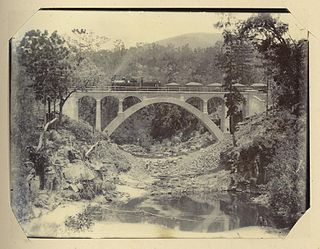
Steep Rocky Creek Railway Bridge is a heritage-listed railway bridge on the Mungar - Monto railway line at Ideraway in the North Burnett Region of Queensland, Australia. It was designed by William Pagan and built from 1906 to 1907. It was added to the Queensland Heritage Register on 21 October 1992.

Humphery Railway Bridge is a heritage-listed railway bridge on the Mungar to Monto railway line at Humphery, North Burnett Region, Queensland, Australia. It was designed by William Pagan and built in 1913. It was added to the Queensland Heritage Register on 21 October 1992.

Mount Debateable is a rural locality in the North Burnett Region, Queensland, Australia. In the 2016 census, Mount Debateable had a population of 54 people.
Mingo is a rural locality in the North Burnett Region, Queensland, Australia. In the 2016 census, Mingo had a population of 8 people.
Barlyne is a locality in the North Burnett Region, Queensland, Australia. In the 2016 census, Barlyne had a population of 3 people.
Deep Creek is a rural locality in the North Burnett Region, Queensland, Australia. In the 2016 census, Deep Creek had a population of 16 people.
Yenda is a rural locality in the North Burnett Region, Queensland, Australia. In the 2016 census, Yenda had a population of 23 people.
