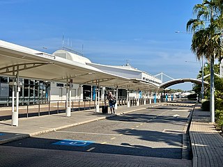
Darwin International Airport is the busiest airport serving the Northern Territory and the tenth busiest airport in Australia. It is the only airport serving Darwin.
Wadeye is a town in Australia's Northern Territory (NT). It was formerly known as Port Keats, a name originating from Port Keats Mission, which operated from 1935 until 1978. In the last few years, Port Keats was run as an Aboriginal reserve by the Northern Territory Government, before being renamed Wadeye when control was passed to the Kardu Numida Council.

Tennant Creek Airport is a small regional airport located near Tennant Creek, Northern Territory, Australia.
Milingimbi Airport is an airport located 2 nautical miles east northeast of Milingimbi on Milingimbi Island in the Northern Territory of Australia. The airport received funding for security upgrades in 2006.
Parap Airfield was the civilian aerodrome of Darwin, Northern Territory, in Australia between 1919 and 1946. Located in the coastal suburb of Parap, it was also known as Darwin Aerodrome and Ross Smith Aerodrome.

Coomalie Creek Airfield was a Royal Australian Air Force (RAAF) airfield built in 1942 in what is now the locality of Coomalie Creek, Northern Territory, Australia during World War II. The airfield fell into disuse after the war ended. Since purchasing the surrounding land in 1977, private owners have restored the runway and rebuilt some wartime buildings to preserve the airfield's history. It was listed on the Northern Territory Heritage Register in 2011, along with a nearby anti-aircraft battery that was used for airfield defence.

Strauss Airfield was an airfield in the Northern Territory of Australia in the locality of Noonamah constructed between 19 March to 27 April 1942 during World War II. It was also known as 27 Mile Field or Humpty Doo Strip.
Gorrie Airfield was a Royal Australian Air Force (RAAF) airfield in the Northern Territory of Australia during World War II located about 10 km (6.2 mi) north of Larrimah and about 67 km (42 mi) south of Mataranka in what is now the locality of Elsey.
The Daly Waters Airfield, also RAAF Base Daly Waters, is a former commercial and sporadically-used military airfield located at Daly Waters, Northern Territory, Australia. As an airfield on Australia's earliest international routes, Daly Waters was used throughout the 1920s and 1930s as a stop over for commercial airlines operating on the domestic route to Western Australia and international carriers flying from Australia into south-east Asia via Darwin. During World War II, the airbase was used by the Royal Australian Air Force (RAAF) and the United States Army Air Force to undertake combat operations against the Japanese in New Guinea, the Dutch East Indies and the islands to Australia's north. Following the war, the airbase was used commercially again up until the 1970s when the airfield was sporadically-used by the RAAF.
Livingstone Airfield was an airfield at what is now Livingstone, Northern Territory, Australia during World War II.
Pell Airfield was an airfield in the Northern Territory of Australia located southeast of Batchelor Airfield near the Stuart Highway in what is now the locality of Adelaide River and which was in use during World War II.

MacDonald Airfield, sometimes recorded as McDonald Airfield, was an airfield built alongside the former northern road, west of Stuart Highway, north of Pine Creek, Northern Territory, Australia during World War II. It is nearby to the Pine Creek Airfield.
Pine Creek Airfield was an emergency landing ground at Pine Creek, Northern Territory, Australia during World War II.
Hughes Airfield is an airfield in the Northern Territory of Australia located in the locality of Hughes. It was constructed during World War II for military use. The airfield now functions as a base for aerial firefighting aircraft to protect the outer rural suburbs of Darwin.
Gould Airfield was an airfield south of Batchelor Airfield at Batchelor, Northern Territory, Australia during World War II.
Snake Bay Airport is located at Milikapiti, Northern Territory on the northern coast of Melville Island, Australia.

Bathurst Island Airport is an airport located at Wurrumiyanga, on the southeast coast of Bathurst Island, in the Northern Territory of Australia.
Sattler Airfield is an abandoned airfield in the Northern Territory of Australia that was constructed 32 km (20 mi) to the south of Darwin during World War II in what is now the locality of Bees Creek. It was named after Flight Lieutenant Geoffery Sattler, the commander of a Lockheed Hudson A16-7, who died on 12 January 1942 at Keema Bay, North Celebes with the rest of his crew. On 2 April 1942, the then new Sattler RAAF airfield was bombed by the Japanese Imperial Forces. There was minimal damage. There were no Allied planes at the base as it was still under construction.


