
The Goulburn River National Park is a national park located in New South Wales, Australia, 213 kilometres (132 mi) northwest of Sydney and it is 35 kilometres (22 mi) south-west of Merriwa. The Goulburn River National Park is located in the Hunter Valley region and covers approximately 90 kilometres (56 mi) of the Goulburn River. It is near the towns of Sandy Hollow, Denman, Merriwa, and Mudgee.

HMAS Goulburn (J167/B243/A117), named for the city of Goulburn, New South Wales, was one of 60 Bathurst-class corvettes constructed during World War II, and one of 20 ordered by the British Admiralty but subsequently manned and commissioned solely by the Royal Australian Navy (RAN).
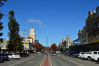
Goulburn is a regional city in the Southern Tablelands of the Australian state of New South Wales, approximately 195 kilometres (121 mi) south-west of Sydney, and 90 kilometres (56 mi) north-east of Canberra. It was proclaimed as Australia's first inland city through letters patent by Queen Victoria in 1863. Goulburn had a population of 23,835 at June 2018. Goulburn is the seat of Goulburn Mulwaree Council.
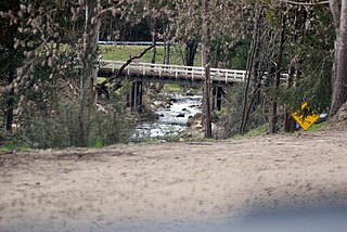
Goulburn River, a perennial river of the Hunter River catchment, is located in the Upper Hunter region of New South Wales, Australia.
The Goulburn Islands are a group of small islands and islets in the Arafura Sea off the coast of Arnhem Land in Northern Territory of Australia. The largest islands are Weyirra and Warruwi, where the climate is slightly cooler than in Darwin. The Warruwi or Maung people are the traditional owners of the Goulburn Islands.

The Goulburn Valley is a sub-region, part of the Hume region of the Australian state of Victoria. The sub-region consists of those areas in the catchment of the Goulburn River and other nearby streams, and is part of the Murray-Darling Basin. The Goulburn Valley is bordered on the south by the Great Dividing Range and to the north by the Murray River, the state border with New South Wales. The sub-region is one of Australia's most productive and intensively farmed areas and is predominantly irrigated.

Goulburn railway station is a heritage-listed railway station on the Main Southern line in New South Wales, Australia. Opened on 19 May 1869, it serves the city of Goulburn. It was added to the New South Wales State Heritage Register on 2 April 1999.
The Delatite River, an inland perennial river of the Goulburn Broken catchment, part of the Murray-Darling basin, is located in the lower South Eastern Highlands bioregion and Northern Country/North Central regions of the Australian state of Victoria. The headwaters of the Delatite River rise on the western slopes of the Victorian Alps and descend to flow into the Goulburn River within Lake Eildon.

Bungonia is a small town in the Southern Tablelands in New South Wales, Australia in Goulburn Mulwaree. At the 2016 census, Bungonia had a population of 367. The name of the town derives from an Aboriginal word meaning 'sandy creek'.
Bow River, a partly perennial stream of the Hunter River catchment, is located in the Hunter district of New South Wales, Australia.
Krui River, a perennial river of the Hunter River catchment, is located in the Upper Hunter region of New South Wales, Australia.
The Mulwaree River, a perennial river that is part of the Hawkesbury-Nepean catchment, is located in the Southern Tablelands region of New South Wales, Australia.
Munmurra River, a perennial river of the Hunter River catchment, is located in the Upper Hunter region of New South Wales, Australia.
Worondi Rivulet, a perennial stream of the Hunter River catchment, is located in the Upper Hunter region of New South Wales, Australia.
The Acheron River, a minor inland perennial river of the Goulburn Broken catchment, part of the Murray-Darling basin, is located in the lower South Eastern Highlands bioregion and Northern Country/North Central regions of the Australian state of Victoria. The headwaters of the Acheron River rise on the north–western slopes of the Yarra Ranges, below The Knobs and descend to flow into the Goulburn River near Alexandra.

The Big River, an inland perennial river of the Goulburn Broken catchment, part of the Murray-Darling basin, is located in the lower South Eastern Highlands bioregion and Northern Country/North Central regions of the Australian state of Victoria. The headwaters of the Big River rise on the northern slopes of the Yarra Ranges and descend to flow into the Goulburn River within Lake Eildon.
The Black River, an inland perennial river of the Goulburn Broken catchment, part of the Murray-Darling basin, is located in the lower South Eastern Highlands bioregion and Northern Country/North Central regions of the Australian state of Victoria. The headwaters of the Black River rise on the northern slopes of the Yarra Ranges and descend to flow into the Goulburn River within the Yarra Ranges National Park.
Goulburn High School is a government-funded co-educational comprehensive secondary day school, located in Goulburn, in the Southern Tablelands region of New South Wales, Australia.
Mulwaree Shire was a local government area in the Southern Tablelands region of New South Wales, Australia.
