
The Lockheed Ventura is a twin-engine medium bomber and patrol bomber of World War II.

Between February 1942 and November 1943, during the Pacific War of World War II, the Australian mainland, domestic airspace, offshore islands, and coastal shipping were attacked at least 111 times by aircraft from the Imperial Japanese Navy Air Force and Imperial Japanese Army Air Force. These attacks came in various forms; from large-scale raids by medium bombers, to torpedo attacks on ships, and to strafing runs by fighters.

Adelaide River is a small but historically significant town located at the crossing of the Stuart Highway over the Adelaide River in the Northern Territory of Australia. The town is upstream of the Adelaide and Mary River Floodplains Important Bird Area. At the 2021 census, Adelaide River had a population of 317. Adelaide River is part of the Coomalie Shire and is the second largest settlement in the local government area.

Larrimah is a remote town and locality in the Northern Territory of Australia, approximately 431 kilometres (268 mi) southeast of the territorial capital of Darwin and 158 kilometres (98 mi) southeast of the municipal seat of Katherine. It is on the Stuart Highway. It was established during the Second World War as the railhead of the North Australia Railway and a significant site for troop movements and military supplies.
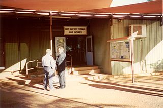
Gove Airport is on the Gove Peninsula in the Northern Territory of Australia. It services the mining town of Nhulunbuy and several Aboriginal communities including Yirrkala. The airport is located 5.8 nautical miles south southeast of the Nhulunbuy town centre, on Melville Road. It is operated by the Nhulunbuy Corporation.

Batchelor is a town in the Northern Territory of Australia. The town is the current seat and largest town of the Coomalie Shire local government area. It is located 98 kilometres (61 mi) south of the territory capital, Darwin. A number of residents commute to Darwin and its suburbs for work. In the 2016 census, Batchelor recorded a population of 507 people, with 36% of Aboriginal and Torres Strait Islander origin.

Coomalie Creek Airfield was a Royal Australian Air Force (RAAF) airfield built in 1942 in what is now the locality of Coomalie Creek, Northern Territory, Australia during World War II. The airfield fell into disuse after the war ended. Since purchasing the surrounding land in 1977, private owners have restored the runway and rebuilt some wartime buildings to preserve the airfield's history. It was listed on the Northern Territory Heritage Register in 2011, along with a nearby anti-aircraft battery that was used for airfield defence.

Batchelor Airfield, is an airport located south of Batchelor, Northern Territory, Australia. The airport currently has no commercial air services; however, it is utilised by the Northern Australian Gliding Club and the Alice Springs Aero Club as a flight training base.

Strauss Airfield was an airfield in the Northern Territory of Australia in the locality of Noonamah constructed between 19 March to 27 April 1942 during World War II. It was also known as 27 Mile Field or Humpty Doo Strip.

Fenton Airfield was a World War II military airfield in the Northern Territory of Australia located at Tipperary Station in what is now the locality of Douglas-Daly and named after flight lieutenant Clyde Fenton.
Pell Airfield was an airfield in the Northern Territory of Australia located southeast of Batchelor Airfield near the Stuart Highway in what is now the locality of Adelaide River and which was in use during World War II.
Long Airfield was a World War II military airfield located in the locality of Douglas-Daly, Northern Territory, Australia.
Hughes Airfield is an airfield in the Northern Territory of Australia located in the locality of Hughes. It was constructed during World War II for military use. The airfield now functions as a base for aerial firefighting aircraft to protect the outer rural suburbs of Darwin.

Katherine Airfield was an airfield in the town of Katherine, Northern Territory, Australia that closed in 1978 when civil operations moved to RAAF Base Tindal, 15 km (9.3 mi) south of Katherine. The site of the airfield is now home to the Katherine Museum.
Manbulloo Airfield was a World War II airfield built at Manbulloo Station, near Katherine, Northern Territory.
Hughes is an outer rural locality of Darwin, located approximately 38 km (24 mi) south-west of the city in the Litchfield Municipality. The name of the locality derived from Hughes Airfield constructed in the area during the Second World War. The airfield itself was named after W A Hughes, Director of Mines in the Northern Territory before the war. The airfield is still in occasional use, occupying much of the western half of the locality adjacent to the Stuart Highway. The eastern portion of Hughes, north of Townend Road is characterised by mostly small farms and rural residential development.
Sattler Airfield is an abandoned airfield in the Northern Territory of Australia that was constructed 32 km (20 mi) to the south of Darwin during World War II in what is now the locality of Bees Creek. It was named after Flight Lieutenant Geoffery Sattler, the commander of a Lockheed Hudson A16-7, who died on 12 January 1942 at Keema Bay, North Celebes with the rest of his crew. On 2 April 1942, the then new Sattler RAAF airfield was bombed by the Japanese Imperial Forces. There was minimal damage. There were no Allied planes at the base as it was still under construction.
Eva Valley is a rural locality in the Coomalie Shire, Northern Territory, Australia. It is located approximately 10 kilometres (6.2 mi) southwest of the town of Batchelor and 110 kilometres (68 mi) south of the Territory capital Darwin.
Coomalie Creek is a locality in the Northern Territory of Australia located about 72 kilometres (45 mi) south-east of the territory capital of Darwin.
Ti-Tree Airfield (ICAO:YTIT), also known as Ti Tree aeroplane landing area (ALA) is a landing strip in the Northern Territory of Australia located in the town of Ti-Tree.
