Saint Anthony Falls, or the Falls of Saint Anthony located at the northeastern edge of downtown Minneapolis, Minnesota, is the only natural major waterfall on the Mississippi River. Throughout the mid-to-late 1800’s, various dams were built atop the east and west faces of the falls to support the milling industry that spurred the growth of the city of Minneapolis. In 1880, the central face of the falls was reinforced with a sloping timber apron to stop the upstream erosion of the falls. In the 1950s, the apron was rebuilt with concrete, which makes up the most visible portion of the falls today. A series of locks were constructed in the 1950s and 1960s to extend navigation to points upstream.

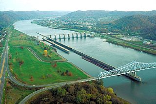
The Monongahela River —often referred to locally as the Mon —is a 130-mile-long (210 km) river on the Allegheny Plateau in north-central West Virginia and Southwestern Pennsylvania. The river flows from the confluence of its west and east forks in north-central West Virginia northeasterly into southwestern Pennsylvania, then northerly to Pittsburgh and its confluence with the Allegheny River to form the Ohio River. The river's entire length is navigable via a series of locks and dams.

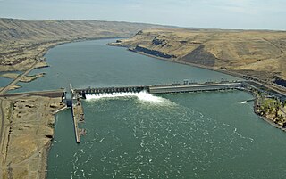
The Dalles Dam is a concrete-gravity run-of-the-river dam spanning the Columbia River, two miles (3 km) east of the city of The Dalles, Oregon, United States. It joins Wasco County, Oregon with Klickitat County, Washington, 300 miles (309 km) upriver from the mouth of the Columbia near Astoria, Oregon. The closest towns on the Washington side are Dallesport and Wishram.
The John Day Dam is a concrete gravity run-of-the-river dam spanning the Columbia River in the northwestern United States. The dam features a navigation lock plus fish ladders on both sides. The John Day Lock has the highest lift of any U.S. lock. The reservoir impounded by the dam is Lake Umatilla, and it runs 76.4 miles (123.0 km) up the river channel to the foot of the McNary Dam. John Day Dam is part of the Columbia River Basin system of dams.

The McAlpine Locks and Dam are a set of locks and a hydroelectric dam at the Falls of the Ohio River at Louisville, Kentucky. They are located at mile point 606.8, and control a 72.9 miles (117.3 km) long navigation pool. The locks and their associated canal were the first major engineering project on the Ohio River, completed in 1830 as the Louisville and Portland Canal, designed to allow shipping traffic to navigate through the Falls of the Ohio.

The McClellan–Kerr Arkansas River Navigation System (MKARNS) is part of the United States inland waterway system originating at the Tulsa Port of Catoosa and running southeast through Oklahoma and Arkansas to the Mississippi River. The total length of the system is 445 miles (716 km). It was named for two senators, Robert S. Kerr (D-OK) and John L. McClellan (D-AR), who pushed its authorizing legislation through Congress. The system officially opened on June 5, 1971. President Richard M. Nixon attended the opening ceremony. It is operated by the Army Corps of Engineers (USACE).

Morgantown Lock and Dam is a navigational lock and a gated dam on the Monongahela River at Morgantown, West Virginia. It is part of a series of dams that canalizes the Monongahela to a depth of at least 9 feet (2.7 m) for its entire length from Fairmont, West Virginia to Pittsburgh, Pennsylvania. It is maintained by the U.S. Army Corps of Engineers' Pittsburgh District.

Opekiska Lock and Dam is a navigational lock and gated dam on the Monongahela River at Lowsville, West Virginia. It is part of a series of dams that canalizes the Monongahela to a depth of at least 9 feet (2.7 m) for its entire length from Fairmont, West Virginia to Pittsburgh, Pennsylvania. It is maintained by the U.S. Army Corps of Engineers' Pittsburgh District.

The Captain Anthony Meldahl Locks and Dam is a non-navigable river control dam with an associated lock, located at mile marker 436 on the Ohio River. It was named for Captain Anthony Meldahl, a river captain.
The Hannibal Locks and Dam are a United States Army Corps of Engineers concrete locks and lift gate dam, located at river mile marker 126.4 on the Ohio River at Hannibal, Ohio, and New Martinsville, West Virginia. The locks and dam were built to replace the wicket-type locks and dams Number 12, 13 and 14. Construction on the locks were started in 1967 and completed in 1972. Construction on the dams were started in 1970 and completed in 1975.
Braddock Locks & Dam is one of nine navigational structures on the Monongahela River between Pittsburgh, Pennsylvania and Fairmont, West Virginia. Built and maintained by the U.S. Army Corps of Engineers, the gated dam and the lock form an upstream pool that is for 12.6 miles (20.3 km), stretching to Elizabeth, Pennsylvania.

C.W. Bill Young Lock and Dam in Harmar Township, Allegheny County, Pennsylvania, and Plum, Pennsylvania, is a lock that was built in 1932. The lock and fixed-crest dam were built by the U.S. Army Corps of Engineers as a part of an extensive system of locks and dams to improve navigation along the Allegheny River.

The Allegheny River Lock and Dam No. 4 in Harrison Township, Allegheny County, Pennsylvania, is a lock that was built 1920-1927, and opened in 1927, 24.2 miles upstream from the mouth of the river in Pittsburgh. The lock and dam were built by the U.S. Army Corps of Engineers as a part of an extensive system of locks and dams to improve navigation along the Allegheny River.

Allegheny River Lock and Dam No. 5 is a historic lock and fixed-crest dam complex located at Gilpin Township and South Buffalo Township in Armstrong County, Pennsylvania. It was built between 1920 and 1927 by the United States Army Corps of Engineers, and consists of the lock, dam, esplanade, and Operations Building. The lock measures 56 feet by 360 feet, and has a lift of 11.6 feet. The dam measures approximately 22 feet high and 632 feet long.
Allegheny River Lock and Dam No. 6 is a historic lock and fixed-crest dam complex located at Bethel Township and South Buffalo Township in Armstrong County, Pennsylvania. It was built between 1927 and 1928 by the United States Army Corps of Engineers, and consists of the lock, dam, esplanade, Operations Building, and two locktenders' houses. The lock measures 56 feet by 360 feet, and has a lift of 12.4 feet. The dam measures approximately 20 feet high and 992 feet long. The Operations Building, or powerhouse, is a utilitarian two-story building in a vernacular early-20th century revival style. The locktenders' houses are identical two-story, brick dwellings on concrete foundations. The lock and dam were built by the U.S. Army Corps of Engineers as a part of an extensive system of locks and dams to improve navigation along the Allegheny River.
Allegheny River Lock and Dam No. 7 is a historic lock and fixed-crest dam complex located at East Franklin Township, Pennsylvania and Kittanning in Armstrong County, Pennsylvania. It was built between 1928 and 1930 by the United States Army Corps of Engineers, and consists of the lock, dam, esplanade, and Operations Building. The lock measures 56 feet by 360 feet, and has a lift of 13.0 feet. The dam measures approximately 20 feet high and 916 feet long. The Operations Building, or powerhouse, is a utilitarian two-story building in a vernacular early-20th century revival style. The lock and dam were built by the U.S. Army Corps of Engineers as a part of an extensive system of locks and dams to improve navigation along the Allegheny River.

Allegheny River Lock and Dam No. 8 is a historic lock and fixed-crest dam complex located at Boggs Township and Washington Township in Armstrong County, Pennsylvania. It was built between 1929 and 1931 by the United States Army Corps of Engineers, and consists of the lock, dam, esplanade, and Operations Building. The lock measures 56 feet by 360 feet, and has a lift of 17.8 feet. The dam measures approximately 50 feet high and 916 feet long; a three-foot addition was built on top of the dam in 1937. The Operations Building, or powerhouse, is a utilitarian two-story building in a vernacular early-20th century revival style. The lock and dam were built by the U.S. Army Corps of Engineers as a part of an extensive system of locks and dams to improve navigation along the Allegheny River.

Allegheny River Lock and Dam No. 9 is a historic lock and fixed-crest dam complex located at Madison Township and Washington Township in Armstrong County, Pennsylvania. It was built between 1935 and 1938 by the United States Army Corps of Engineers, and includes the lock, dam, steel miter gates, and Operations Building. The lock measures 56 feet by 360 feet, and has a lift of 22 feet. The dam measures approximately 60 feet high and 918 feet long. The Operations Building, or powerhouse, is a utilitarian two-story building in a vernacular early-20th century revival style. The lock and dam were built by the U.S. Army Corps of Engineers as a part of an extensive system of locks and dams to improve navigation along the Allegheny River.

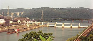
Emsworth Locks and Dam is a combination of locks and dam on the Ohio River located just downstream of Pittsburgh. The dam has two gated sections, one on each side of Neville Island. There are two locks, one for commercial barge traffic that is 600 feet long by 110 feet wide, and the recreational auxiliary lock that is 360 feet long by 56 feet wide. Emsworth averages about 470 commercial lock throughs every month and 350-400 lock throughs a month on the recreational auxiliary lock.

Dashields Lock and Dam is a fixed-crest dam on the Ohio River. It is located less than 15 miles down stream of Pittsburgh. There are two locks, one for commercial barge traffic that's 600 feet long by 110 feet wide, and the recreational auxiliary lock is 360 feet long by 56 feet wide. Dashields locks averages about 450 commercial lock throughs every month and 200-300 lock throughs a month on the recreational auxiliary lock.