Alleruusakasiit

Last updated
Alleruusakasiit
Agdlerussakasit

Stordalens Havn with Agdlerussakasit on skyline.jpg

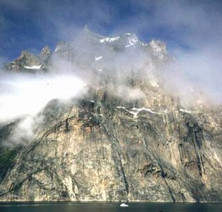
View of Stordalen Havn in Torsukattak Fjord with the Alleruusakasiit in the background
Highest point
Elevation 1,743.7 m (5,721 ft)
Coordinates 60°8′8″N44°31′44″W / 60.13556°N 44.52889°W / 60.13556; -44.52889 Coordinates: 60°8′8″N44°31′44″W / 60.13556°N 44.52889°W / 60.13556; -44.52889 [1]
Geography
Greenland edcp relief location map.jpg
Red triangle with thick white border.svg
Alleruusakasiit

Alleruusakasiit, former spelling Agdlerussakasit, is a mountain in the Kujalleq municipality, southern Greenland.

Mountain A large landform that rises fairly steeply above the surrounding land over a limited area

A mountain is a large landform that rises above the surrounding land in a limited area, usually in the form of a peak. A mountain is generally steeper than a hill. Mountains are formed through tectonic forces or volcanism. These forces can locally raise the surface of the earth. Mountains erode slowly through the action of rivers, weather conditions, and glaciers. A few mountains are isolated summits, but most occur in huge mountain ranges.

Kujalleq Municipality in Greenland, Kingdom of Denmark

Kujalleq is a municipality on the southern tip of Greenland, operational from 1 January 2009. The administrative center of the municipality is in Qaqortoq. The municipality consists of the former municipalities of southern Greenland, each named after the biggest settlement:

Greenland autonomous country within the Kingdom of Denmark

Greenland is an autonomous constituent country of the Kingdom of Denmark between the Arctic and Atlantic oceans, east of the Canadian Arctic Archipelago. Though physiographically a part of the continent of North America, Greenland has been politically and culturally associated with Europe for more than a millennium. The majority of its residents are Inuit, whose ancestors began migrating from the Canadian mainland in the 13th century, gradually settling across the island.

Contents

Geography

This mountain is a 1,743.7 m high largely unglaciated rocky summit rising 2.8 km west of the shore of Torsukattak Fjord [2] located across the valley south of Angiartarfik. [3]

Torsukattak Fjord

Torsukattak is a fjord in far southern Greenland. Administratively it is part of the Kujalleq municipality.

Angiartarfik

Angiartarfik, former spelling Angîârtarfik, is a mountain in the Kujalleq municipality, southern Greenland.

Alleruusakasiit is famous for its massive eastern cliff, known as the Thumbnail. [4]

Cliff A vertical, or near vertical, rock face of substantial height

In geography and geology, a cliff is a vertical, or nearly vertical, rock exposure. Cliffs are formed as erosion landforms by the processes of weathering and erosion. Cliffs are common on coasts, in mountainous areas, escarpments and along rivers. Cliffs are usually formed by rock that is resistant to weathering and erosion. Sedimentary rocks most likely to form cliffs include sandstone, limestone, chalk, and dolomite. Igneous rocks such as granite and basalt also often form cliffs.

Thumbnail (cliff)

The Thumbnail is a sea cliff in Kujalleq, South Greenland.

See also

Related Research Articles

Uummannaq Fjord

Uummannaq Fjord is a large fjord system in the northern part of western Greenland, the largest after Kangertittivaq fjord in eastern Greenland. It has a roughly south-east to west-north-west orientation, emptying into the Baffin Bay in the northwest.

Ukkusissat Place in Greenland, Kingdom of Denmark

Ukkusissat is a settlement in the Avannaata municipality, in northwestern Greenland. The population of the settlement was 170 in 2010. The name means soapstone.

Appat Island island in Greenland

Appat Island is an uninhabited island in the Qaasuitsup municipality in northwestern Greenland. At 211 km2 (81.5 sq mi), it is one of the larger islands in the Uummannaq Fjord system, located in its north-central part. It is the site of the former settlements of Ritenbenck and Qaqortuatsiaq.

Amarortalik Island island in Greenland

Amarortalik Island is an uninhabited island in the Qaasuitsup municipality in northwestern Greenland. The name of the island means "the place of wolves" in the Greenlandic language.

Akuliaruseq Island

Akuliaruseq Island is an uninhabited island in the Qaasuitsup municipality in northwestern Greenland.

Torsukattak Strait is a strait in the Qaasuitsup municipality in northwestern Greenland.

Qaqortuatsiaq

Qaqortuatsiaq is a former settlement on the northern shore of Appat Island in the Qaasuitsup municipality in northwestern Greenland. Its ruins lay against the Torsukattak Strait of Uummannaq Fjord.

Prince Christian Sound sound

The Prince Christian Sound is a waterway in Southern Greenland. It separates the mainland from Sammisoq and other islands of the Cape Farewell Archipelago near the southernmost tip of Greenland. The name was given in honour of the prince, later king Christian VIII of Denmark.

Cape Farewell Archipelago

Cape Farewell Archipelago is an island group located at the southern end of Greenland in Kujalleq municipality. The archipelago takes its name from Cape Farewell, a headland of Egger Island.

Stordalen Havn

Stordalen Havn is a small, sheltered natural harbour at the northern end of Torsukattak Fjord in the district of Nanortalik, in Greenland.

Upernattivik island in Greenland

Upernattivik, also known as Upernarsuak, is an uninhabited island in King Frederick VI Coast, southeastern Greenland. Administratively it is part of the Sermersooq municipality.

Kangerlussuaq Fjord, East Greenland Fjord Greenland, Sermersooq

Kangerlussuaq Fjord is a fjord in eastern Greenland. It is part of the Sermersooq municipality.

Torsukattak Fjord (Disko Bay)

Torsukattak is a fjord in western Greenland. Administratively it is part of the Qaasuitsup municipality.

Mount Paatusoq

Mount Paatusoq, also known as 'Mount Patuersoq', is the highest mountain in the Kujalleq municipality, SE Greenland.

Petermann Peak

Petermann Peak,, also known as Petermann Fjeld, Petermanns Topp and Petermann Point is a mountain in King Christian X Land, Northeast Greenland. Administratively it is part of the Northeast Greenland National Park zone.

References

  1. GoogleEarth
  2. "Torsukattak". Mapcarta. Retrieved 10 June 2016.
  3. "Later visits to Stordalens Havn". 1975 University of St Andrews Greenland Expedition. Retrieved 10 June 2016.
  4. Ian Parnell: Learning Process. American Alpine Journal (AAJ) 2001, pp. 57–70, Greenland: The Thumbnail. Fragile moments, pp. 61–65