Aogashima, Tokyo

Last updated • 3 min readFrom Wikipedia, The Free Encyclopedia
Aogashima
青ヶ島村
Village
Aogashima-mura office.jpg
Aogashima Village Hall
Flag of Aogashima, Tokyo.svg
Emblem of Aogashima, Tokyo.svg
Aogashima in Tokyo Prefecture Ja.svg
Location of Aogashima in Tokyo Metropolis
Japan location map with side map of the Ryukyu Islands.svg
Red pog.svg
Aogashima
 
Coordinates: 32°27′58.9″N139°45′48.1″E / 32.466361°N 139.763361°E / 32.466361; 139.763361
Country Japan
Region Kantō
Prefecture Tokyo Metropolis
Area
  Total5.96 km2 (2.30 sq mi)
Population
 (Oct 2018)
  Total169
  Density28.2/km2 (73/sq mi)
Time zone UTC+9 (Japan Standard Time)
- Tree Persea
- Flower Lilium
- Bird Japanese wood pigeon
Phone number04996-9-0111
AddressMubanchi 100-1701, Aogashima-mura, Tokyo
Website www.vill.aogashima.tokyo.jp

Aogashima (青ヶ島村, Aogashima-mura) is a village located in Hachijō Subprefecture, Tokyo Metropolis, Japan. It is the least-populated municipality in Japan, with an estimated population of 169 and a population density of 28.2 persons per km2 as of 2018. Its total area is 5.96 square kilometres (2.30 sq mi). [1]

Contents

Geography

Aogashima Village covers the island of Aogashima, the southernmost and most isolated populated island in the Izu archipelago in the Philippine Sea, 358.4 kilometres (222.7 mi) south of central Tokyo, and 71.4 kilometres (44.4 mi) south of Hachijō-jima, its nearest populated neighbor. Warmed by the Kuroshio Current, the town has a warmer and wetter climate than central Tokyo.[ citation needed ]

Neighboring municipalities

History

It is uncertain when human settlement first began on Aogashima, but the island was known to be inhabited in the early Edo period, and is mentioned in historical records kept by the Tokugawa shogunate in Hachijōjima. During a major volcanic eruption in 1785, a large number of islanders perished, and the remainder were evacuated to Hachijōjima. An 1835 census reported 241 inhabitants (133 men, 108 women), mostly engaged in fishing.

On April 1, 1940, the island came under the administrative jurisdiction of Hachijō Subprefecture. The population is centered on two hamlets; Yasundogō (休戸郷) in the east and Nishigō (西郷) in the west.

Demographics

Around 100 of the approximately 170 villagers are natives of the island. The non-native population largely consists of public sector employees, such as school staff and police, many of whom are temporarily transferred to the island. [1]

The average age of the population was 44.5 as of 2020. Older residents are often forced to leave the island due to its lack of hospital or elder care facilities. [1]

As of 2018, the government forecast that the village population will fall to 104 by 2045. [1]

Historical population
YearPop.±%
1970 234    
1980 192−17.9%
1990 203+5.7%
2000 203+0.0%
2010 201−1.0%
2020 169−15.9%

Economy

The public sector is the largest industry in Aogashima, with two local construction companies. The island is famous for its shochu and salt production. [1]

Government

The village government employs 28 people and has an annual budget of JPY 1.04 billion, 35.5% of which is directly subsidized by the Tokyo Metropolitan Government. Local taxes cover only 4.1% of the government's budget. [1]

The village mayor resigned in December 2018 following a scandal involving improper contracting and disbursements, but was re-elected without a vote in January 2019. A vice-mayor post was created in April 2019 to improve village governance. [1]

Transportation

Due to its lack of natural harbors and strong currents, Aogashima has always been difficult to access. The wharf at the island's only port can handle small ships of up to 500 tons, and is unusable during times of high waves and inclement weather. [1]

Toho Air Service provides daily helicopter service to the island from Hachijōjima Airport, a 20-minute flight which is limited to 9 passengers and is regularly booked a month in advance. There is also scheduled ferry service from Hachijōjima four or five days a week, which takes around two and a half hours, but is often subject to cancellation due to high waves at the port. [1]

Education

Because Aogashima has a small population, there is one school that is available to elementary and junior high school students. Aogashima Elementary-Junior High School ( 青ヶ島村立青ヶ島小中学校 ) serves student populations. [2] As of March 2022, the school had 11 elementary students, 3 junior high students, and 24 faculty and staff, making it one of the largest employers in the village. The school briefly had no junior high students in the spring of 2022, but 3 students were brought from outside the island to keep the junior high program active. [1]

Related Research Articles

<span class="mw-page-title-main">Motobu, Okinawa</span> Town in Okinawa Prefecture, Japan

Motobu is a town located in Kunigami District, Okinawa Prefecture, Japan. As of October 2016, the town has an estimated population of 13,441 and a density of 250 persons per km2. The total area is 54.30 square kilometres (20.97 sq mi).

<span class="mw-page-title-main">Kitadaitō, Okinawa</span> Village in Kyushu, Japan

Kitadaitō is a village consisting of the islands of Kitadaitōjima and Okidaitōjima of Shimajiri District, Okinawa Prefecture, Japan.

<span class="mw-page-title-main">Ogasawara, Tokyo</span> Village in the Ogasawara Islands, Japan

Ogasawara is a village in Ogasawara Subprefecture, Tokyo Metropolis, Japan, that governs the Bonin Islands, Volcano Islands, and three remote islands.

<span class="mw-page-title-main">Izu Islands</span> Island group in southeastern Japan

The Izu Islands are a group of volcanic islands stretching south and east from the Izu Peninsula of Honshū, Japan. Administratively, they form two towns and six villages; all part of Tokyo Prefecture. The largest is Izu Ōshima, usually called simply Ōshima.

<span class="mw-page-title-main">Tomari, Hokkaido</span> Village in Hokkaido, Japan

Tomari is a village located in Shiribeshi Subprefecture, Hokkaido, Japan. As of September 2016, the village had a population of 1,750, and a density of 21 persons per km2. The total area is 82.35 square kilometres (31.80 sq mi).

<span class="mw-page-title-main">Haboro, Hokkaido</span> Town in Hokkaido, Japan

Haboro is a town located in Rumoi Subprefecture, Hokkaido, Japan.

<span class="mw-page-title-main">Taketomi Island</span> Island within Ryukyu Islands

Taketomi Island is an island in the town of Taketomi, within Yaeyama District of Okinawa Prefecture, Japan. Taketomi is one of the Yaeyama Islands. The population of Taketomi Island was 323 as of January 2012.

<span class="mw-page-title-main">Shikine-jima</span>

Shikine-jima (式根島) is a volcanic Japanese island in the Philippine Sea. The island is administered by Tōkyō and located approximately 160 kilometres (99 mi) south of Tōkyō and 36 kilometres (22 mi) south of Shimoda Shizuoka Prefecture. It is one of the Izu Seven Islands group of the seven northern islands of the Izu archipelago. The island is the smaller inhabited component of the village of Niijima, which also contains the larger, neighboring island of Niijima and the smaller, uninhabited Jinai-tō. It is part of the Ōshima Subprefecture of Tokyo Metropolis. As of 2009, the island's population was 600. Shikinejima is also within the boundaries of the Fuji-Hakone-Izu National Park.

<span class="mw-page-title-main">To-shima, Tokyo</span> Village in Japan

Toshima is a village located in Ōshima Subprefecture, Tokyo Metropolis, Japan. The village comprises the whole of To-shima Island.

<span class="mw-page-title-main">Hachijō Subprefecture</span> Subprefecture of Tokyo

Hachijō Subprefecture is a subprefecture of Tokyo Metropolis, Japan. The organization of government belongs to the Tokyo Metropolitan Government Bureau Of General Affairs.

<span class="mw-page-title-main">Aogashima</span> Volcanic island in the Philippine Sea

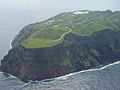
Aogashima (青ヶ島) is a volcanic island to the south of Japan in northernmost Micronesia. It is the southernmost and most isolated inhabited island of the Izu Islands. The islands border the northeast Philippine Sea and lie north of the Ogasawara Islands. The island lies approximately 358 kilometres (222 mi) south of mainland Tokyo and 64 kilometres (40 mi) south of Hachijō-jima.

<span class="mw-page-title-main">Miyake, Tokyo</span> Village in Kantō, Japan

Miyake is a village located in Miyake Subprefecture, Tokyo Metropolis, Japan. As of 1 October 2020, the village had an estimated population of 2,273, and a population density of 41.1 persons per km2. Its total area is 55.27 square kilometres (21.34 sq mi).

<span class="mw-page-title-main">Hachijō, Tokyo</span> Town in Kantō, Japan

Hachijō is a town located in Hachijō Subprefecture, Tokyo Metropolis, Japan. As of 1 December 2022, the town had an estimated population of 7,056, and a population density of 97.7 persons per km2. Its total area is 72.24 square kilometres (27.89 sq mi). Electric power for the town is provided by a geothermal power station and by a wind farm.

<span class="mw-page-title-main">Kōzushima, Tokyo</span> Village in Kantō, Japan

Kōzushima Village is a village located in Ōshima Subprefecture, Tokyo Metropolis, Japan. As of 1 June 2022, the village had an estimated population of 1,841, and a population density of 99 persons per km2. Its total area is 18.58 square kilometres (7.17 sq mi).

<span class="mw-page-title-main">Ōshima, Tokyo</span> Town in Kantō, Japan

Ōshima is a town located in Ōshima Subprefecture, Tokyo Metropolis, Japan. As of 1 October 2020, the town had an estimated population of 7,102, and a population density of 78.3 persons per km2. Its total area is 90.76 square kilometres (35.04 sq mi).

<span class="mw-page-title-main">Mikurajima, Tokyo</span> Village in Kantō, Japan

Mikurajima Village is a village located in Miyake Subprefecture, Tokyo Metropolis, Japan. As of 1 October 2020, the village had an estimated population of 323, and a population density of 11.7 persons per km2. Its total area is 20.54 square kilometres (7.93 sq mi).

<span class="mw-page-title-main">Niijima, Tokyo</span> Village in Kantō, Japan

Niijima is a village located in Ōshima Subprefecture, Tokyo Metropolis, Japan. As of 1 October 2020, the village had an estimated population of 2,441, and a population density of 88.6 persons per km2. Its total area is 27.54 square kilometres (10.63 sq mi).

<span class="mw-page-title-main">Hachijō-kojima</span> Small volcanic island in the Philippine Sea

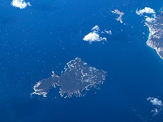
Hachijō-kojima (八丈小島) is a small volcanic deserted island in the Philippine Sea approximately 287 kilometres (178 mi) south of Tokyo, and 7.5 kilometres (4.7 mi) west of Hachijō-jima, in the northern Izu archipelago, Japan. Administratively the island is within Hachijō, Tokyo, Japan.

<span class="mw-page-title-main">Tonaki, Okinawa</span> Village in Kyushu, Japan

Tonaki is a village located in Shimajiri District, Okinawa Prefecture, Japan. The village consists of Tonaki Island and the uninhabited Irisuna Island.

<span class="mw-page-title-main">Minamidaitō, Okinawa</span> Village in Kyushu, Japan

Minamidaitō is a village located entirely on Minamidaitōjima in Shimajiri District, Okinawa Prefecture, Japan. Minamidaitōjima is located approximately 360 kilometres (220 mi) east of Okinawa Island. Minamidaitō covers 30.7 square kilometres (11.9 sq mi).

References

  1. 1 2 3 4 5 6 7 8 9 10 "人口最少の自治体、青ケ島村の行方". Nihon Keizai Shimbun. 2023-03-25. Retrieved 2023-03-25.
  2. "東京都島しょ地区町村小中学校教員公募へ応募される教員の皆様へ" (PDF) (in Japanese). Tokyo Metropolitan Board of Education . Retrieved 2022-11-05.