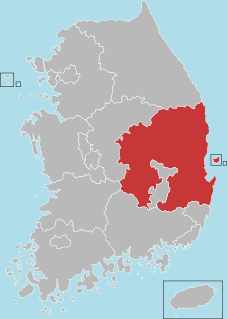
North Gyeongsang Province is a province in eastern South Korea. The province was formed in 1896 from the northern half of the former Gyeongsang province, and remained a province of Korea until the country's division in 1945, then became part of South Korea.

Kampong Speu is a province (khaet) of Cambodia. It borders the provinces of Pursat and Kampong Chhnang to the north, Kandal to the east, Takéo to the southeast, Kampot to the south and Koh Kong to the west. Its capital is Chbar Mon town.

Thredbo is a village and ski resort in the Snowy Mountains of New South Wales, Australia, situated in a part of the Snowy Monaro Regional Council, and has been operated by Event Hospitality and Entertainment since 1987. It is about 500 kilometres (310 mi) south of Sydney, accessible by the Alpine Way via Cooma, Berridale, and Jindabyne. The village is built in the valley of the Thredbo River, also known as the Crackenback River, at the foot of the Ramshead Range.

The Taygetus, Taugetus, Taygetos or Taÿgetus is a mountain range on the Peloponnese peninsula in Southern Greece. The highest mountain of the range is Mount Taygetus, also known as "Profitis Ilias", or "Prophet Elias" (Elijah).

The Baling District is an administrative district in southeastern Kedah, Malaysia. Located about 110 km from Alor Setar, it borders Perak and Betong, the southernmost town of Thailand.

Tōbetsu is a town located in Ishikari, Hokkaido, Japan.

Hartbeespoort, informally also known as "Harties", is a small resort town in the North West Province of South Africa, situated on slopes of the Magaliesberg mountain and the banks of the Hartbeespoort Dam. The name of the town means "gateway of the hartbees" in Afrikaans. Schoemansville, named after General Hendrik Schoeman, a Boer General in the Anglo-Boer War, who owned the farm that the Hartbeespoort Dam was built on, is the oldest neighbourhood of Hartbeespoort.

The Köpet Dag, Kopet Dagh, or Koppeh Dagh, also known as the Turkmen-Khorasan Mountain Range, is a mountain range on the border between Turkmenistan and Iran that extends about 650 kilometres (400 mi) along the border southeast of the Caspian Sea, stretching northwest-southeast from near the Caspian Sea in the northwest to the Harirud River in the southeast. The highest peak of the range in Turkmenistan is the Mount Rizeh, located at the southwest of the capital Ashgabat and stands at 2,940 metres (9,646 ft). The highest Iranian summit is Mount Quchan with 3,191 metres (10,469 ft).

San Rufo is a village and comune in the province of Salerno, in the Campania region of southern Italy located in the Vallo di Diano. San Rufo extends over 31 square kilometres, much of which is mountainous or hilly terrain. With defence in mind, the old town was built at over 600 meters above sea level. Another reason for the choice of location was the marshy nature of the wide Vallo di Diano plain, which sits at an average 450 metres above sea level.
Terchová is a large village and municipality in the Malá Fatra mountains in the Žilina District in the Žilina Region of northern Slovakia.

Dibaj is a city in the Central District of Damghan County, Semnan Province, Iran. At the 2006 census, its population was 2,504, in 680 families.
Bihud is a village in, and the administrative center of Pishkuh Rural District, in the Central District of Qaen County, South Khorasan Province, Iran. At the 2006 census, its population was 1,461, in 497 families. The village is located 50 kilometers away from the west of Qaen.
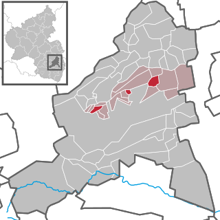
Herxheim am Berg is an Ortsgemeinde – a municipality belonging to a Verbandsgemeinde, a kind of collective municipality – in the Bad Dürkheim district in Rhineland-Palatinate, Germany.

Jonchères is a commune in the Drôme department in southeastern France, in the region of Auvergne-Rhône Alpes. It is located in the Béous valley, an affluent of the left bank of the Drôme river. The village is on a small winding road that climbs from the town of Luc-en-Diois 8 kilometres away, toward Prémol Pass. The village is at an altitude of 911 metres, surrounded by mountains thick with fir and pine. The closest nearby villages are Poyols, Bellegarde-en-Diois and Volvent. The sub-prefecture is 25 kilometres away.

Saint-Sauveur-en-Rue is a commune in the Loire department in central France.

Maramureș is a geographical, historical and cultural region in northern Romania and western Ukraine. It is situated in the northeastern Carpathians, along parts of the upper Tisza River drainage basin; it covers the Maramureș Depression and the surrounding Carpathian mountains.

Unusual place names are names for cities, towns, and other regions which are considered non-ordinary in some manner. This can include place names which are also offensive words, inadvertently humorous or highly charged words, as well as place names of unorthodox spelling and pronunciation, including especially short or long names. These names often have an unintended effect or double-meaning when read by someone who speaks another language.

Ardhagiri is a hill where Hanuman temple is located. The hill is situated in Aragonda village of Chittoor district in the Indian state of Andhra Pradesh.
Noqol is a village in Padena-ye Olya Rural District, Padena District, Semirom County, Isfahan Province, Iran. At the 2006 census, its population was 315, in 73 families.

Mount Saint Mary, originally known as Holm, is an inselberg in the north of Ljubljana, the capital of Slovenia. The mountain is part of the city's Šmarna Gora District. It is the highest hill in the city and a popular hiking destination.

