This article needs additional citations for verification .(April 2017) |
Aripeka, Florida | |
|---|---|
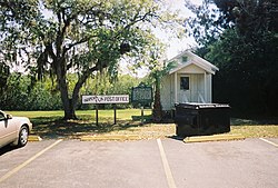 The historic former Aripeka Post Office on the Pasco County side of the town | |
 Location of Aripeka in Hernando County and Pasco County, Florida. | |
 Aripeka  Aripeka | |
| Coordinates: 28°25′56″N82°39′51″W / 28.43222°N 82.66417°W | |
| Country | United States |
| State | Florida |
| Counties | Pasco, Hernando |
| Area | |
• Total | 1.02 sq mi (2.64 km2) |
| • Land | 0.82 sq mi (2.13 km2) |
| • Water | 0.20 sq mi (0.52 km2) |
| Elevation | 5 ft (2 m) |
| Population (2020) | |
• Total | 320 |
| • Density | 389.29/sq mi (150.40/km2) |
| Time zone | UTC-5 (Eastern (EST)) |
| • Summer (DST) | UTC-4 (EDT) |
| ZIP Code | 34679 (originally 33502) |
| Area code | 727 |
| FIPS code | 12-01875 [2] |
| GNIS feature ID | 0293914 [3] |
Aripeka is an unincorporated community and census-designated place (CDP) in the U.S. state of Florida, along the coast of the Gulf of Mexico at the border dividing Pasco and Hernando counties. The ZIP Code for the community is 34679, but it was originally assigned as 33502. As of the 2020 census, the population was 320.


