Armenia, Wisconsin

Last updated

Armenia, Wisconsin
WIMap-doton-Armenia.png
Location of Armenia, Wisconsin
Coordinates: 44°10′12″N90°1′0″W / 44.17000°N 90.01667°W / 44.17000; -90.01667
Country Flag of the United States.svg  United States
State Flag of Wisconsin.svg  Wisconsin
County Juneau
Area
  Total77.7 sq mi (201.2 km2)
  Land66.0 sq mi (170.9 km2)
  Water11.7 sq mi (30.3 km2)
Elevation
[1]
945 ft (288 m)
Population
 (2000)
  Total707
  Density10.7/sq mi (4.1/km2)
Time zone UTC-6 (Central (CST))
  Summer (DST) UTC-5 (CDT)
Area code 608
FIPS code 55-02850 [2]
GNIS feature ID1582715 [1]

Armenia is a town in Juneau County, Wisconsin, United States. The population was 707 at the 2000 census. The unincorporated community of New Miner is located in the town.

Contents

Geography

According to the United States Census Bureau, the town has a total area of 77.7 square miles (201.2 km2), of which, 66.0 square miles (170.9 km2) of it is land and 11.7 square miles (30.3 km2) of it (15.05%) is water.

Demographics

As of the census [2] of 2000, there were 707 people, 267 households, and 190 families residing in the town. The population density was 10.7 people per square mile (4.1/km2). There were 448 housing units at an average density of 6.8 per square mile (2.6/km2). The racial makeup of the town was 90.10% White, 0.14% African American, 0.71% Native American, 0.14% Pacific Islander, 7.92% from other races, and 0.99% from two or more races. Hispanic or Latino of any race were 9.34% of the population.

There were 267 households, out of which 28.5% had children under the age of 18 living with them, 56.9% were married couples living together, 8.6% had a female householder with no husband present, and 28.5% were non-families. 23.6% of all households were made up of individuals, and 9.0% had someone living alone who was 65 years of age or older. The average household size was 2.61 and the average family size was 3.08.

In the town, the population was spread out, with 26.3% under the age of 18, 6.4% from 18 to 24, 28.6% from 25 to 44, 25.2% from 45 to 64, and 13.6% who were 65 years of age or older. The median age was 38 years. For every 100 females, there were 125.2 males. For every 100 females age 18 and over, there were 118.0 males.

The median income for a household in the town was $35,568, and the median income for a family was $39,063. Males had a median income of $27,750 versus $22,500 for females. The per capita income for the town was $19,539. About 7.1% of families and 11.2% of the population were below the poverty line, including 3.1% of those under age 18 and 22.8% of those age 65 or over.

See also

Related Research Articles

<span class="mw-page-title-main">Taylor, Alabama</span> Town in Alabama, United States

Taylor is a town in Geneva and Houston counties in the U.S. state of Alabama. Taylor was first settled in the 1870s, named after an early family that helped secure the first post office. It was not incorporated until almost a century later in June 1967. It is part of the Dothan, Alabama Metropolitan Statistical Area. At the 2010 census the population was 2,375, up from 1,898 in 2000.

<span class="mw-page-title-main">Carmel, Maine</span> Town in the state of Maine, United States

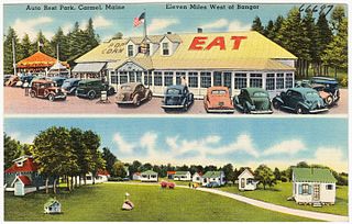
Carmel is a town in Penobscot County, Maine, United States. It is part of the Bangor Metropolitan Statistical Area. The population was 2,867 at the 2020 census.

<span class="mw-page-title-main">Centerview, Missouri</span> Village in Missouri, United States

Centerview is a village in Johnson County, Missouri, United States. The population was 267 at the 2010 census.

<span class="mw-page-title-main">Gilbert, South Carolina</span> Town in South Carolina, United States

Gilbert is a town in Lexington County, South Carolina, United States. The population was 569 at the 2010 census. It is part of the Columbia, South Carolina Metropolitan Statistical Area.

<span class="mw-page-title-main">Maple Grove, Barron County, Wisconsin</span> Town in Wisconsin, United States

The Town of Maple Grove is located in Barron County in the U.S. state of Wisconsin. The population was 979 at the 2010 census. The unincorporated community of Hillsdale is located in the town. The unincorporated community of Wickware is located partially in the town.

<span class="mw-page-title-main">Dewhurst, Wisconsin</span> Town in Wisconsin, United States

Dewhurst is a town in Clark County in the U.S. state of Wisconsin. The population was 323 at the 2010 census. The ghost town of Trow was located in the town.

<span class="mw-page-title-main">Bennett, Wisconsin</span> Town in Wisconsin, United States

Bennett is a town in Douglas County, Wisconsin, United States. The population was 597 at the 2010 census. The unincorporated communities of Beebe and Bennett are located in the town.

<span class="mw-page-title-main">Ashford, Wisconsin</span> Town in Wisconsin, United States

Ashford is a town in Fond du Lac County, Wisconsin, United States. The population was 1,773 at the 2000 census. The unincorporated communities of Ashford and Elmore are located in the town.

<span class="mw-page-title-main">Byron, Monroe County, Wisconsin</span> Town in Wisconsin, United States

Byron is a town in Monroe County, Wisconsin, United States. The population was 1,394 at the 2000 census. The unincorporated communities of Shennington and Valley Junction are located in the town.

<span class="mw-page-title-main">Maple Valley, Wisconsin</span> Town in Wisconsin, United States

Maple Valley is a town in Oconto County, Wisconsin, United States. The population was 670 at the 2000 census. The unincorporated communities of Frostville and Hickory Corners are located in the town.

<span class="mw-page-title-main">Liberty, Outagamie County, Wisconsin</span> Town in Wisconsin, United States

There are three other towns called 'Liberty' in Wisconsin. See Liberty, Wisconsin
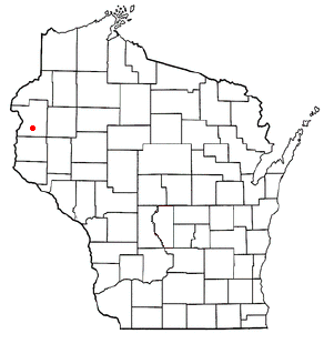
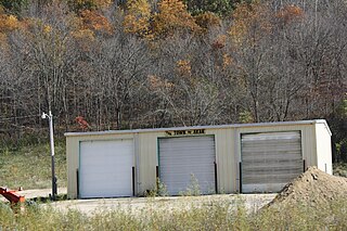
<span class="mw-page-title-main">Garfield, Polk County, Wisconsin</span> Town in Wisconsin, United States

The Town of Garfield is located in Polk County, Wisconsin, United States. The population was 1,443 at the 2000 census. The unincorporated communities of Sand Lake, Ubet, and Wanderoos are located within the town.

<span class="mw-page-title-main">Akan, Wisconsin</span> Town in Wisconsin, United States

Akan is a town in Richland County, Wisconsin, United States. The population was 444 at the 2000 Census. The unincorporated communities of Five Points and Jimtown are located in the town.

<span class="mw-page-title-main">Eagle, Richland County, Wisconsin</span> Town in Wisconsin, United States

Eagle is a town in Richland County, Wisconsin, United States. The population was 593 at the 2000 census. The unincorporated communities of Balmoral, Basswood, and Eagle Corners are located in the town.

<span class="mw-page-title-main">St. Albans, Maine</span> Town in the state of Maine, United States

St. Albans is a town in Somerset County, Maine, United States. The population was 2,045 at the 2020 census.

<span class="mw-page-title-main">Adams, Adams County, Wisconsin</span> Town in Wisconsin, United States

Adams is a town in Adams County in the U.S. state of Wisconsin. The population was 1,378 at the 2020 census. The city of Adams is located within the town. The ghost town of Adams Center was also located in the town.

<span class="mw-page-title-main">Ridgeway, Wisconsin</span> Village in Wisconsin, United States

Ridgeway is a village in Iowa County, Wisconsin, United States. The population was 624 at the 2020 census. The village is adjacent to the Town of Ridgeway. It is part of the Madison Metropolitan Statistical Area.

Trempealeau is a town in Trempealeau County, Wisconsin, United States. The population was 1,618 at the 2000 census. The town surrounds the village of Trempealeau. The unincorporated communities of Centerville, West Prairie, and Wrights Corners are in the town.

<span class="mw-page-title-main">Guilford, Maine</span> Town in the state of Maine, United States

Guilford is a town in Piscataquis County, Maine, United States. The town is located on the Piscataquis River and was first settled in 1806. The population was 1,267 at the time of the 2020 census.

Hartland is a town in Somerset County, Maine, United States. The population was 1,705 at the 2020 census.

References

  1. 1 2 "US Board on Geographic Names". United States Geological Survey. October 25, 2007. Retrieved January 31, 2008.
  2. 1 2 "U.S. Census website". United States Census Bureau . Retrieved January 31, 2008.