Lindina, Wisconsin

Last updated

Town of Lindina, Wisconsin
WIMap-doton-Lindina.png
Location of the Town of Lindina, Wisconsin
Coordinates: 43°47′4″N90°8′5″W / 43.78444°N 90.13472°W / 43.78444; -90.13472
Country Flag of the United States.svg  United States
State Flag of Wisconsin.svg  Wisconsin
County Juneau
Area
  Total33.1 sq mi (85.7 km2)
  Land33.1 sq mi (85.7 km2)
  Water0 sq mi (0 km2)
Elevation
[1]
978 ft (298 m)
Population
 (2000)
  Total730
  Density22/sq mi (8.5/km2)
Time zone UTC-6 (Central (CST))
  Summer (DST) UTC-5 (CDT)
Area code 608
FIPS code 55-44675 [2]
GNIS feature ID1583575 [1]

The Town of Lindina is in Juneau County, Wisconsin, United States. The population was 730 at the 2000 census.

Contents

Geography

According to the United States Census Bureau, the town has a total area of 33.1 square miles (85.8 km2), all of it land.

Demographics

As of the census [2] of 2000, there were 730 people, 263 households, and 199 families residing in the town. The population density was 22 people per square mile (8.5/km2). There were 287 housing units at an average density of 8.7 per square mile (3.3/km2). The racial makeup of the town was 98.63% White, 0.41% African American, 0.27% Asian, 0.14% from other races, and 0.55% from two or more races. Hispanic or Latino people of any race were 0.55% of the population.

There were 263 households, out of which 37.3% had children under the age of 18 living with them, 67.7% were married couples living together, 3.8% had a female householder with no husband present, and 24% were non-families. 19.8% of all households were made up of individuals, and 10.6% had someone living alone who was 65 years of age or older. The average household size was 2.78 and the average family size was 3.2.

In the town, the population was spread out, with 30.4% under the age of 18, 4.8% from 18 to 24, 24.9% from 25 to 44, 24.9% from 45 to 64, and 14.9% who were 65 years of age or older. The median age was 38 years. For every 100 females, there were 102.8 males. For every 100 females age 18 and over, there were 99.2 males.

The median income for a household in the town was $41,250, and the median income for a family was $44,792. Males had a median income of $29,286 versus $21,406 for females. The per capita income for the town was $16,047. About 5.3% of families and 7.3% of the population were below the poverty line, including 8.1% of those under age 18 and 8% of those age 65 or over.

Related Research Articles

<span class="mw-page-title-main">St. Leon, Indiana</span> Town in Indiana, United States

St. Leon or Saint Leon is a town in Kelso Township, Dearborn County, Indiana, United States. The population was 678 at the 2010 census.

<span class="mw-page-title-main">Dublin, Indiana</span> Town in Indiana, United States

Dublin is a town in Jackson Township, Wayne County, in the U.S. state of Indiana. The population was 679 at the 2020 census.

<span class="mw-page-title-main">Bridgewater, Maine</span> Town in the state of Maine, United States

Bridgewater is a town in Aroostook County, Maine, United States. The population was 532 at the 2020 census.

<span class="mw-page-title-main">St. Agatha, Maine</span> Town in the state of Maine, United States

St. Agatha is a town in Aroostook County, Maine, United States. The population was 730 at the 2020 census.

<span class="mw-page-title-main">Pittston, Maine</span> Town in the state of Maine, United States

Pittston is a town in Kennebec County, Maine, United States. The population was 2,875 at the 2020 census. The town was named after the family of John Pitt, who were early settlers. Pittston is included in the Augusta, Maine micropolitan New England City and Town Area.

Danforth is a town in Washington County, Maine, United States. The town was named for proprietor Thomas Danforth. The population was 587 at the 2020 census. The town contains the villages of Danforth and Eaton. East Grand High School is located in Danforth.

<span class="mw-page-title-main">West Milford, West Virginia</span> Town in West Virginia, United States

West Milford is a town in Harrison County, West Virginia, United States. The population was 452 at the 2020 census.

<span class="mw-page-title-main">Cairo, West Virginia</span> Town in West Virginia, United States

Cairo is a town in Ritchie County, West Virginia, United States, along West Virginia Route 31, the North Fork of the Hughes River, and the North Bend Rail Trail. The population was 174 at the 2020 census.

<span class="mw-page-title-main">Hambleton, West Virginia</span> Town in West Virginia, United States

Hambleton is a town in Tucker County, West Virginia, United States. The population was 216 at the 2020 census. Hambleton was established in 1889, but not incorporated until 1905. It was named by then United States Senator Stephen B. Elkins in honor of a stockholder by this name in the West Virginia Central Railroad Company. The town was previously known as Hulings.

<span class="mw-page-title-main">Camden-on-Gauley, West Virginia</span> Town in West Virginia, United States

Camden-on-Gauley is a town in Webster County, West Virginia, United States, along the Gauley River. The population was 126 at the 2020 census.

<span class="mw-page-title-main">Sherman, Clark County, Wisconsin</span> Town in Wisconsin, United States

Sherman is a town in Clark County, Wisconsin, United States. The population was 831 at the 2000 census. The unincorporated community of Veefkind is located in the town. The unincorporated community of Spokeville is also located partially in the town.

<span class="mw-page-title-main">Worden, Wisconsin</span> Town in Wisconsin, United States

Worden is a town in Clark County in the U.S. state of Wisconsin. The population was 657 at the 2000 census.

<span class="mw-page-title-main">Perry, Wisconsin</span> Town in Wisconsin, United States

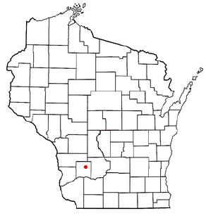
Perry is a town in Dane County, Wisconsin, United States. The population was 737 at the 2020 census. The unincorporated communities of Daleyville and Forward are located in the town.

<span class="mw-page-title-main">Rockbridge, Wisconsin</span> Town in Wisconsin, United States

Rockbridge is a town in Richland County, Wisconsin, United States. The population was 721 at the 2000 census. The unincorporated communities of Rockbridge and Buck Creek are located in the town.

<span class="mw-page-title-main">Grant, Shawano County, Wisconsin</span> Town in Wisconsin, United States

Grant is a town in Shawano County, Wisconsin, United States. The population was 974 at the 2000 census. The unincorporated community of Caroline is located within the town, and it holds the town's fire station.

<span class="mw-page-title-main">Glenwood, Wisconsin</span> Town in Wisconsin, United States

Glenwood is a town in St. Croix County, Wisconsin, United States. The population was 755 at the 2000 census. The unincorporated community of Emerald is located partially in the town.

<span class="mw-page-title-main">Preston, Trempealeau County, Wisconsin</span> Town in Wisconsin, United States

Preston is a town in Trempealeau County, Wisconsin, United States. The population was 951 at the 2000 census.

<span class="mw-page-title-main">Stinnett, Wisconsin</span> Town in Wisconsin, United States

Stinnett is a town in Washburn County, Wisconsin, United States. The population was 263 at the 2000 census. The unincorporated community of Stanberry is located in the town, situated 7 miles (11 km) west of Hayward on County Highway M. The ghost town of Harmon was located in the town.

<span class="mw-page-title-main">Deerfield, Waushara County, Wisconsin</span> Town in Wisconsin, United States

Deerfield is a town in Waushara County, Wisconsin, United States. The population was 629 at the 2000 census.

<span class="mw-page-title-main">Niagara (town), Wisconsin</span> Town in Wisconsin, United States

Niagara is a town in Marinette County, Wisconsin, United States. The population was 924 at the 2000 census. The city of Niagara is located to the north of and adjacent to the town.

References

  1. 1 2 "US Board on Geographic Names". United States Geological Survey. October 25, 2007. Retrieved January 31, 2008.
  2. 1 2 "U.S. Census website". United States Census Bureau . Retrieved January 31, 2008.