Armstrong's Point

Last updated
Armstrong's Point
Neighbourhood
East Blanchard Park Winnipeg.jpg
East Blanchard Park, Winnipeg
Canada Manitoba location map 2.svg
Red pog.svg
Armstrong's Point
Coordinates: 49°52′37″N97°9′23″W / 49.87694°N 97.15639°W / 49.87694; -97.15639
Country Flag of Canada (Pantone).svg  Canada
Province Flag of Manitoba.svg  Manitoba
Established1880
Government
  CouncillorSherri Rollins
  MLALisa Naylor
  MPLeah Gazan
Area
  Total0.3 km2 (0.1 sq mi)
Elevation
234 m (768 ft)
Population
 (2021)
  Total295
  Density1,391.1/km2 (3,603/sq mi)
Time zone UTC−6 (CST)
  Summer (DST) UTC−5 (CDT)
Forward Sortation Area
R3C
Area codes 204, 431
[1]

Armstrong's Point (informally referred to as The Gates) is a neighbourhood in Winnipeg, Manitoba. [2] It is located in the West End of the city and in a large bend in the Assiniboine River. The land was developed in the late 19th and early 20th centuries as a residential district. [3]

Contents

History

The Hudson's Bay Company deeded the land to Joseph Hill who arrived at Red River of the North in 1849 with a Pensioner Regiment. The area was originally called Point-a-Peltier. [4] In 1854, returning to England, Hill put James Armstrong (1790-1874) in charge of the property. Hearing of Hill's death, the property was sold to Francis Evans Cornish, the first mayor of Winnipeg. In the early 1880s, Hill returned to Winnipeg, and reestablished his ownership of the land before selling it to a speculators' syndicate in April 1881 for $28,000. The speculators renamed the area Victoria Place, though officially it was known as Registered Plan 119. [5]

During the period of 1880 through 1920, houses were built on its four roads, Cornish Avenue, East Gate, West Gate, and Middle Gate. [6] The first home was completed in 1882.

Architecture

Some of the buildings in Armstrong's Point that are historically significant are:

Gates

The Gates at East Gate, West Gate, Middle Gate, were designed by the architect Lt. Col. Henry Norland Ruttan in 1911, [8] and built in the same year. Flanking three entrances to the Winnipeg neighbourhood, they are nearly identical construction, built of stone and wrought-iron, and of Classical Revival style. Funded by residents and built by the city's engineering department, the Gates are unique, having been built by the property owners instead of a real estate developer. [9]

Politics

Armstrong's Point is represented by Sherri Rollins in the city ward of Fort Rouge - East Fort Garry at the municipal level, [10] Lisa Naylor in the constituency of Wolseley at the provincial level, and Leah Gazan in the constituency of Winnipeg Centre at the federal level. [11] (For census data, Statistics Canada places Armstrong's Point as part of the Downtown community area). [12]

Overall, the neighbourhood is politically diverse and does not generally support any candidate with a large majority. [13] [11] [14] Voter turnout for the 2008 federal election was 56%. [11]

Demographics


As of 2021, the population of the neighbourhood was 295 people. The median household income in Armstrong's Point was $162,000, more than double the median of the city which was $80,000. There was a 0% unemployment rate, and 88.7% of the residents held a post-secondary certificate, diploma, or degree.

There were 125 dwellings in Armstrong's Point, all single detached houses with an average of 9 rooms. 85.2% of the houses were owned, with the average dwelling value being $690,000. [1]

Related Research Articles

<span class="mw-page-title-main">Fort Garry</span> Historic trading post in present-day downtown Winnipeg, Manitoba, Canada

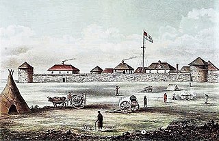
Fort Garry, also known as Upper Fort Garry, was a Hudson's Bay Company trading post at the confluence of the Red and Assiniboine rivers in what is now downtown Winnipeg.

<span class="mw-page-title-main">Charleswood, Winnipeg</span> Suburb of Winnipeg

Charleswood is a residential community and neighbourhood in Winnipeg, Manitoba, Canada. It is located in the South-West of the city and is bordered by the neighbourhoods Tuxedo to the East, Fort Whyte to the South, and the Rural Municipality of Headingley on the West. It's boundaries are Roblin and the Assiniboine River to the north, Shaftesbury Boulevard on the East, Wilkes Avenue to the South and the Perimeter Highway to the West.

<span class="mw-page-title-main">St. Vital (electoral district)</span> Provincial electoral district in Manitoba, Canada

St. Vital is a provincial electoral division in the Canadian province of Manitoba.

The Winnipeg City Council is the governing body of the city of Winnipeg, Manitoba, Canada. The Council is seated in the Council Building of Winnipeg City Hall.

<span class="mw-page-title-main">Portage and Main</span> Intersection in downtown Winnipeg

Portage and Main is an intersection in downtown Winnipeg, Manitoba, Canada, located where Portage Avenue and Main Street intersect. The corner is known as the "crossroads of Canada", due to its relative proximity to the longitudinal centre of Canada.

Old Kildonan is the northernmost city ward of Winnipeg, Manitoba. Before the City of Winnipeg Act of 1972, it was an independent unincorporated municipality called the Municipality of Old Kildonan; prior to that, from 1914, it was a subdivision of the Rural Municipality of Kildonan.

St. Vital is a ward and neighbourhood of Winnipeg, Manitoba, Canada.

<span class="mw-page-title-main">Fort Rouge, Winnipeg</span>

Fort Rouge is a district of Winnipeg, Manitoba, in Canada. Located in the south-central part of the city, it is bounded on the north by the Assiniboine River, on the east and south by the Red River, and on the west by Stafford Street and Pembina Highway.

<span class="mw-page-title-main">Fort Garry, Winnipeg</span> Suburb of Winnipeg, Canada

Fort Garry is a community area and neighbourhood of Winnipeg, Manitoba, Canada, located in the southwestern part of the city, south of the district of Fort Rouge and east of the Tuxedo area. It comprises parts of the city wards of River Heights - Fort Garry, Fort Rouge - East Fort Garry, Waverley West, and St. Norbert - Seine River.

<span class="mw-page-title-main">Osborne Village</span> Neighbourhood in Winnipeg, Manitoba, Canada

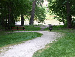
Osborne Village is a neighbourhood of Winnipeg, Manitoba. The area is bordered by the Assiniboine River on the north and west, Harkness Station on the east, and the Osborne Underpass on the south.

<span class="mw-page-title-main">St. James-Assiniboia, Winnipeg</span> Suburb in Winnipeg, Manitoba, Canada

St. James-Assiniboia is a major community area in Winnipeg, Manitoba, Canada. As it encapsulates most of the city ward of St. James, which includes the major St. James Street, the area itself is often simply referred to "St. James."

<span class="mw-page-title-main">West End, Winnipeg</span> Urban area in Manitoba, Canada

The West End is a mostly residential area of Downtown Winnipeg, Manitoba, Canada. It includes the neighbourhoods of Armstrong's Point, Colony, Daniel McIntyre, Minto, Sargent Park, Spence, St. Matthews, West Broadway, and Wolseley.

<span class="mw-page-title-main">St. Norbert, Winnipeg</span> Suburb of Winnipeg

St. Norbert is a bilingual neighbourhood and the southernmost suburb of Winnipeg, Manitoba, Canada. While outside the Perimeter Highway, it is still part of the city. As of the 2016 Census, the population of St. Norbert is 5,850.

Wildwood Park is a suburban, planned community in Winnipeg that has a central green space and no front roads, with communal walkways, playgrounds, and parks.

Waverley West is a city ward and suburb in southwest Winnipeg, Manitoba.

<span class="mw-page-title-main">History of Winnipeg</span>

The history of Winnipeg comprises its initial population of Aboriginal peoples through its settlement by Europeans to the present day. The first forts were built on the future site of Winnipeg in the 1700s, followed by the Selkirk Settlement in 1812. Winnipeg was incorporated as a city in 1873 and experienced dramatic growth in the late 19th and early 20th centuries. Following the end of World War I, the city's importance as a commercial centre in Western Canada began to wane. Winnipeg and its suburbs experienced significant population growth after 1945, and the current City of Winnipeg was created by the unicity amalgamation in 1972.

Winnipeg, Manitoba, is subdivided in different ways for different purposes. The suburbs and neighbourhoods of Winnipeg take their names from former administrative districts, parishes, and geographic features.

<span class="mw-page-title-main">Cornish Library</span> Public library in Winnipeg

The Cornish Library, is a branch of the Winnipeg Public Library, located in Winnipeg, Manitoba, Canada. Like the St. John's Library, the Cornish is one of two Carnegie libraries in the city. It is a Grade II listed building and a Winnipeg Landmark Heritage Structure. It was gazetted on January 15, 1993. It is named in honour of Winnipeg's first mayor, Francis Evans Cornish.

Broadway is a street in the city of Winnipeg, Manitoba, Canada. It is one of the city's oldest and most historic routes and forms the Trans-Canada Highway route through the city's downtown.

References

Sources
Notes
  1. 1 2 3 , Armstrong Point 2021 Census. Retrieved January 30, 2024
  2. "TimeLinks: Armstrong's Point". The Manitoba Historical Society. 29 August 2009. Retrieved 28 April 2011.
  3. LeBoldus, Pamela; Rosemary Malaher (Spring 1983). "A Walking Tour of Armstrong's Point". Manitoba History. The Manitoba Historical Society. 5.
  4. Martin, Archer (1898). The Hudson's Bay company's land tenures and the occupation of Assiniboia. W. Clowes & Sons. pp.  81. Retrieved 28 April 2011.
  5. Historical Buildings Committee (August 1993). "Armstrong's Point Gates Cornish Avenue" (PDF). City of Winnipeg. Archived from the original (PDF) on 22 March 2012. Retrieved 28 April 2011.
  6. Pyzer, Nan (29 August 2009). "TimeLinks: Armstrong's Point". The Manitoba Historical Society. Retrieved 30 April 2011.
  7. 1 2 Rostecki, Randy R. (2009). Armstrong's Point - A History. Heritage Winnipeg Corporation. pp. 46, 234. ISBN   9780969511212.
  8. "Armstrong's Point Gate". Lib.umanitoba.ca. University of Manitoba Libraries. Archived from the original on 24 July 2011. Retrieved 28 April 2011.
  9. "Gates at East Gate, West Gate, Middle Gate". Historicplaces.ca. Parks Canada. Retrieved 30 April 2011.
  10. "Fort Rouge - East Fort Garry Ward | Electoral Wards". Winnipeg.ca. Retrieved 2021-06-28.
  11. 1 2 3 "Map of Results - Winnipeg Centre (2008)". Electionmapper.ca. Retrieved 2019-08-27.
  12. "(UD) : 2016 Census". Winnipeg.ca. Retrieved 10 January 2022.
  13. Turner, James (October 29, 2010). "Election 2010 : October 27, 2010 : Councillor Fort Rouge - East Ft. Garry (Vote for 1)" (PDF). Winnipeg Crime Files.
  14. "Manitoba election 2019: Live results and riding-by-riding vote counts". Macleans.ca. Retrieved 2019-09-14.