Astoria, South Dakota

Last updated

Astoria, South Dakota
Deuel County South Dakota Incorporated and Unincorporated areas Astoria Highlighted.svg
Location in Deuel County and the state of South Dakota
USA South Dakota location map.svg
Red pog.svg
Astoria
Location in South Dakota
Usa edcp location map.svg
Red pog.svg
Astoria
Astoria (the United States)
North America laea location map.svg
Red pog.svg
Astoria
Astoria (North America)
Coordinates: 44°33′28″N96°32′47″W / 44.55778°N 96.54639°W / 44.55778; -96.54639
Country United States
State South Dakota
County Deuel
Incorporated1917 [1]
Area
[2]
  Total0.16 sq mi (0.41 km2)
  Land0.16 sq mi (0.41 km2)
  Water0.00 sq mi (0.00 km2)
Elevation
[3]
1,821 ft (555 m)
Population
 (2020) [4]
  Total132
  Density840.76/sq mi (324.64/km2)
Time zone UTC-6 (Central (CST))
  Summer (DST) UTC-5 (CDT)
ZIP code
57213
Area code 605
FIPS code 46-02580 [5]
GNIS feature ID1267272 [3]

Astoria is a town in Deuel County, South Dakota, United States. The population was 132 at the 2020 census. [6]

Contents

History

Astoria was platted in 1900. [7] The town was named after Astoria, Oregon. [8] A post office has been in operation at Astoria since 1900. [9]

Geography

According to the United States Census Bureau, the town has a total area of 0.16 square miles (0.41 km2), all land. [10]

Demographics

Historical population
CensusPop.Note
1920 221
1930 2314.5%
1940 214−7.4%
1950 206−3.7%
1960 176−14.6%
1970 153−13.1%
1980 1540.7%
1990 1550.6%
2000 150−3.2%
2010 139−7.3%
2020 132−5.0%
U.S. Decennial Census [11] [4]

2010 census

As of the census [12] of 2010, there were 139 people, 61 households, and 32 families residing in the town. The population density was 868.8 inhabitants per square mile (335.4/km2). There were 74 housing units at an average density of 462.5 per square mile (178.6/km2). The racial makeup of the town was 100.0% White.

There were 61 households, of which 27.9% had children under the age of 18 living with them, 45.9% were married couples living together, 1.6% had a female householder with no husband present, 4.9% had a male householder with no wife present, and 47.5% were non-families. 41.0% of all households were made up of individuals, and 9.9% had someone living alone who was 65 years of age or older. The average household size was 2.28 and the average family size was 3.22.

The median age in the town was 41.3 years. 25.2% of residents were under the age of 18; 3.7% were between the ages of 18 and 24; 24.5% were from 25 to 44; 34.4% were from 45 to 64; and 12.2% were 65 years of age or older. The gender makeup of the town was 52.5% male and 47.5% female.

2000 census

As of the census [5] of 2000, there were 150 people, 69 households, and 40 families residing in the town. The population density was 952.1 inhabitants per square mile (367.6/km2). There were 75 housing units at an average density of 476.0 per square mile (183.8/km2). The racial makeup of the town was 97.33% White, 1.33% Asian, and 1.33% from two or more races. Hispanic or Latino of any race were 2.00% of the population.

There were 69 households, out of which 24.6% had children under the age of 18 living with them, 42.0% were married couples living together, 13.0% had a female householder with no husband present, and 40.6% were non-families. 39.1% of all households were made up of individuals, and 24.6% had someone living alone who was 65 years of age or older. The average household size was 2.17 and the average family size was 2.93.

In the town, the population was spread out, with 23.3% under the age of 18, 7.3% from 18 to 24, 19.3% from 25 to 44, 22.0% from 45 to 64, and 28.0% who were 65 years of age or older. The median age was 45 years. For every 100 females, there were 92.3 males. For every 100 females age 18 and over, there were 109.1 males.

The median income for a household in the town was $24,375, and the median income for a family was $34,375. Males had a median income of $26,250 versus $18,750 for females. The per capita income for the town was $14,642. There were 17.8% of families and 19.3% of the population living below the poverty line, including 35.9% of under eighteens and 17.9% of those over 64.

Related Research Articles

<span class="mw-page-title-main">Arco, Minnesota</span> City in Minnesota, United States

Arco is a city in Lincoln County, Minnesota, United States. The population was 87 at the 2020 census.

<span class="mw-page-title-main">Stratford, South Dakota</span> Town in South Dakota, United States

Stratford is a town in southern Brown County, South Dakota, United States. The population was 57 at the 2020 census.

<span class="mw-page-title-main">Westport, South Dakota</span> Town in South Dakota, United States

Westport is a town in western Brown County, South Dakota, United States. The population was 88 at the 2020 census.

<span class="mw-page-title-main">Wagner, South Dakota</span> City in South Dakota, United States

Wagner is a city in Charles Mix County, South Dakota, United States. The population was 1,490 at the 2020 census. The city is served by Wagner Municipal Airport as well as YST Transit buses.

<span class="mw-page-title-main">Florence, South Dakota</span> Town in South Dakota, United States

Florence is a town in northwestern Codington County, South Dakota, United States. It is part of the Watertown, South Dakota Micropolitan Statistical Area. The population was 337 at the 2020 census.

<span class="mw-page-title-main">Fairburn, South Dakota</span> Town in South Dakota, United States

Fairburn is a town in Custer County, South Dakota, United States. The population was 60 at the 2020 census.

<span class="mw-page-title-main">Ethan, South Dakota</span> Town in South Dakota, United States

Ethan is a town in Davison County, South Dakota, United States. It is part of the Mitchell, South Dakota Micropolitan Statistical Area. The population was 365 at the 2020 census. Ethan is located 10 miles south of Mitchell.

<span class="mw-page-title-main">Andover, South Dakota</span> Town in South Dakota, United States

Andover is a town in northwestern Day County, South Dakota, United States. The population was 66 at the 2020 census.

<span class="mw-page-title-main">Altamont, South Dakota</span> Town in South Dakota, United States

Altamont is a town in Deuel County, South Dakota, United States. The population was 32 at the 2020 census.

<span class="mw-page-title-main">Brandt, South Dakota</span> Town in South Dakota, United States

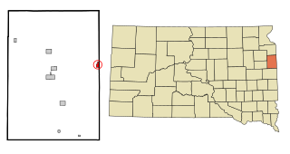
Brandt is a town in Deuel County, South Dakota, United States. The population was 114 at the 2020 census.

<span class="mw-page-title-main">Clear Lake, South Dakota</span> City in South Dakota, United States

Clear Lake is a city in and the county seat of Deuel County, South Dakota, United States. The population was 1,218 at the 2020 census.

<span class="mw-page-title-main">Gary, South Dakota</span> City in South Dakota, United States

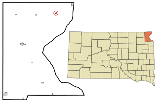
Gary is a city in Deuel County, South Dakota, United States. The population was 240 at the 2020 census. South Dakota Highway 101 serves as the main route of the community. In 2022, the town celebrated its 150th anniversary.

<span class="mw-page-title-main">Goodwin, South Dakota</span> Town in South Dakota, United States

Goodwin is a town in Deuel County, South Dakota, United States, where the population was 147 at the 2020 census.

<span class="mw-page-title-main">Toronto, South Dakota</span> Town in South Dakota, United States

Toronto is a town in Deuel County, South Dakota, United States. The population was 196 at the 2020 census.

<span class="mw-page-title-main">Revillo, South Dakota</span> Town in South Dakota, United States

Revillo is a town in southeastern Grant County, South Dakota, United States. The population was 99 at the 2020 census.

<span class="mw-page-title-main">Hudson, South Dakota</span> Town in South Dakota, United States

Hudson is a town in Lincoln County, South Dakota, United States. The population was 311 at the 2020 census. It is the easternmost community in South Dakota.

<span class="mw-page-title-main">Lake City, South Dakota</span> Town in South Dakota, United States

Lake City is a town in Marshall County, South Dakota, United States. The population was 45 at the 2020 census. Fort Sisseton Historic State Park, whose fort is listed on the National Register of Historic Places, is located nearby.

<span class="mw-page-title-main">Crooks, South Dakota</span> City in South Dakota, United States

Crooks is a city in Minnehaha County, South Dakota, United States and is a suburb of Sioux Falls. The population was 1,362 at the 2020 census. Crooks was named New Hope until 1904. The town's present name honors W. A. Crooks, a local politician.

<span class="mw-page-title-main">Rosholt, South Dakota</span> Town in South Dakota, United States

Rosholt is a town in Roberts County, South Dakota, United States. The population was 379 at the 2020 census.

<span class="mw-page-title-main">Tulare, South Dakota</span> Town in South Dakota, United States

Tulare is a town in Spink County, South Dakota, United States. The population was 211 at the 2020 census.

References

  1. "SD Towns" (PDF). South Dakota State Historical Society. Archived from the original (PDF) on February 10, 2010. Retrieved February 10, 2010.
  2. "ArcGIS REST Services Directory". United States Census Bureau. Retrieved October 15, 2022.
  3. 1 2 U.S. Geological Survey Geographic Names Information System: Astoria, South Dakota
  4. 1 2 "Census Population API". United States Census Bureau. Retrieved October 15, 2022.
  5. 1 2 "U.S. Census website". United States Census Bureau . Retrieved January 31, 2008.
  6. "U.S. Census Bureau: Astoria town, South Dakota". www.census.gov. United States Census Bureau. Retrieved February 20, 2022.
  7. Chicago and North Western Railway Company (1908). A History of the Origin of the Place Names Connected with the Chicago & North Western and Chicago, St. Paul, Minneapolis & Omaha Railways. p. 39.
  8. Federal Writers' Project (1940). South Dakota place-names, v.1-3. University of South Dakota. p. 23.
  9. "Deuel County". Jim Forte Postal History. Retrieved January 22, 2015.
  10. "US Gazetteer files 2010". United States Census Bureau. Archived from the original on January 12, 2012. Retrieved June 21, 2012.
  11. "Census of Population and Housing". Census.gov. Retrieved June 4, 2016.
  12. "U.S. Census website". United States Census Bureau . Retrieved June 21, 2012.