This article needs additional citations for verification .(December 2013) |
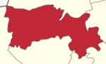
Attur Taluk is one of the taluks, or administrative division of Salem District in the state of Tamil Nadu, India. The division's headquarters is Attur town.
This article needs additional citations for verification .(December 2013) |
Attur Taluk is one of the taluks, or administrative division of Salem District in the state of Tamil Nadu, India. The division's headquarters is Attur town.
Attur Taluk is surrounded by Gangavalli Taluk on east and Pethanaickenpalayam Taluk on the west. Recently, the railway station was rebuilt and the tracks expanded to accommodate a broad gauge. Train services run from Viruthachalam to Salem, and from Attur to Chennai.
Transportation
Attur is on NH 79. Attur is well connected with Salem on the west at 55 kilometres and Kallakkurichi on the east (north-east) at 45 kilometres on the Salem-Ulunderpet NH 79 which in turn connects to Chennai through arterial NH 45 at Ulunderpet and NH 47 (Salem-Kanyakumari via Coimbatore, Cochin, Trivandrum) at Salem with a number of bus routes.
Private buses are operated between Attur and nearby towns/villages. Tamil Nadu State run corporation, formerly known as Anna Transport Corporation (ATC), in Salem district compete with private buses in that area.
Train services run between Attur to Salem, Attur to Virudhachalam and Salem-Chennai Egmore express train runs via Attur. The frequency of operation is very low; one in each direction in the morning and one in the evening. Pondicherry-Bangalore AC express train (Puducherry Yesvantpur Garib Rath Express) runs via Attur.
Attur has many lorry transport services including Southern Roadways Ltd (TVS), ABT, ARC and other daily transporters. In Attur, the Southern Roadways branch was run by Late Mr. K.R. Ramanathan, from 1950 till 1993. He was the agent since the inception of Southern Roadways in Tamil Nadu. During his tenure, he earned a good name in Attur.
Attur is landlocked and depends on the Port of Chennai for most oceangoing freight.
Nearest airport is Salem Airport which is 55 km from the town.
Villages in the vicinity include Thalavaipatti and Paithoor. Another notable village here is Gudamalai, located along the Thamampatti to Gangavalli highway. It is surrounded by hills on all four sides.
| Sl. No | City or Village Name |
|---|---|
| 1 | PunalVasal |
| 2 | Abinavam |
| 3 | Adhiyanur |
| 4 | Akkichettipalayam |
| 5 | Ammampalayam |
| 6 | Appamasamudram |
| 7 | Aragalur |
| 8 | Arana Block |
| 9 | Arasanatham |
| 10 | Arathi Agraharam |
| 11 | Ariyapalayam |
| 12 | Attavanai Kothampady |
| 13 | Atthur |
| 14 | Azhaga Puram |
| 15 | B.Karadi Patty |
| 16 | C.K.Hills Vadakku |
| 17 | Chinna Krishnapuram |
| 18 | Chinnama Samudram |
| 19 | Ck Hills Therkku |
| 20 | Deviyakurichy |
| 21 | Echampatty |
| 22 | Edayapatty |
| 23 | Errama Samudram |
| 24 | Etthapur |
| 25 | Gopalapuram |
| 26 | Govindampalayam |
| 27 | Jadaya Koundan Sarivu_Rf |
| 28 | Jari Kothambadi |
| 29 | Kalarampatty |
| 30 | Kallanatham |
| 31 | Kalleri Patty |
| 32 | Kalpaganur |
| 33 | Kalyana Giri |
| 34 | Kamakkapalayam |
| 35 | Karia Kovil Valavu |
| 36 | Kattukottai |
| 37 | Keel Avarai |
| 38 | Keeri Patti |
| 39 | Kottavadi |
| 40 | Kumarapalayam |
| 41 | Kunoor |
| 42 | Lakshmana Samutram |
| 43 | Malaiyalapatti |
| 44 | Malliakarai |
| 45 | Manivilunthan |
| 46 | Manjini |
| 47 | Mannur |
| 48 | Mettudaiyam Palayam |
| 49 | Mettupalayam |
| 50 | Mummudi |
| 51 | Muthagoundanur |
| 52 | Muttal |
| 53 | Nadhakarai |
| 54 | Nagalur |
| 55 | Naiyamalai |
| 56 | Narasingapuram |
| 57 | Navakurichy |
| 58 | Navalur navalur pudur |
| 59 | Odda Patty |
| 60 | Olapady |
| 61 | P.K.Hills Mel Nadu |
| 62 | Paithoor |
| 63 | Paithur North (Pudur) |
| 64 | Paithur South |
| 65 | Paithur_Rf |
| 66 | Palania Puri |
| 67 | Pallipalayam |
| 68 | Panamadal |
| 69 | Pattimedu |
| 70 | Pattuthurai |
| 71 | Periya Krishna Puram |
| 72 | Periyeri |
| 73 | Petthanaickan Palayam |
| 74 | A.Karadi Patty |
| 75 | Pungavadi |
| 76 | Puthiragoundampalayam |
| 77 | Puthur |
| 78 | Ramanaickenpalayam |
| 79 | Rangappanaickanpalayam |
| 80 | Sadasivapuram |
| 81 | Sarvoy |
| 82 | Sarvoy Pudur |
| 83 | Sathapady |
| 84 | Seeliampatty |
| 85 | Sekkadi Patty |
| 86 | Siruvachur North |
| 87 | Siruvachur South |
| 88 | Sitheri |
| 89 | Sokkanathapuram |
| 90 | Soolankurichi |
| 91 | Thalaivasal |
| 92 | Thalavaipatti |
| 93 | Thalavaipatty |
| 94 | Thamayanur |
| 95 | Thandanur |
| 96 | Thandavarayapuram |
| 97 | Theerthagiri |
| 98 | Thenkumarai |
| 99 | Thennam Pillaiyur |
| 100 | Thennankudipalayam |
| 101 | Thirumalai Nama Samudram |
| 102 | Thiyaganur |
| 103 | Thulukkanur |
| 104 | Thumbal |
| 105 | Udayampatti |
| 106 | Umayalpuram |
| 107 | Unathur |
| 108 | Vadakumarai |
| 109 | Vadugathampatty |
| 110 | Vaithy Goundan Pudur |
| 111 | Valaiyamadevi |
| 112 | Varagur |
| 113 | Veeragoundanur |
| 114 | Vellapatty |
| 115 | Veppanatham |
| 116 | Vaithiyanadha puram |
| 117 | West Rajapalayam |
| 118 | Santhanagiri |
| 119 | Mulluvadi |
| 120 | Ponnolinagar |
| 121 | WEST PANANTH THOPPU |
Attur is a Selection Grade Municipality town and also the headquarters of Attur Taluk in Salem District. Formerly it was a town panchayat and was constituted as a Municipality with effect from 1.4.1965. It is a class II town. The extent of the Municipal area is 27.62 km2. The population as per 2001 census is 57519.
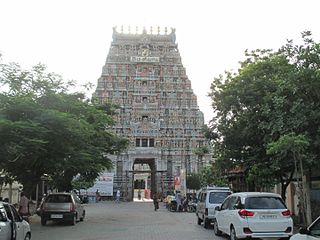
Attur is a very ancient town. Attur is known as the river town. The town is situated on the southern bank of the Vasista river. It dates from 921 and was known as Milattu and Kutratthu Brahmadheyam and Malaiyaman Attur. It came to be known as Attur Ananthagiri during the Mysore rule beginning in 1689,. The name was shortened to Attur at end of the 18th Century. It was formed part of Hyder domines till 1768. Then it surrendered to Mr. Wood of East India Company. Again Hyder regained it from that company. After that company won a decisive victory in the 3rd Mysore was against Thippusultan. The fort war garrisoned in 1792 by the 23rd Madras battalion of the company under the command of captain compbell. The fort remained so until 1854 when it ceased to be military station. Attur fort is now ruined stone fort and situated on the northern bank of the Vasista River occupying an area of 62 acres.
It is constructed by a local palayakarar, C. Lakshmana Nayakan (17th Century). Until recently it was believed to have been built up the founder of the Catti Mudali Dynasty who did built the Siva and Vishnu temples in the fort.
The fort walls (about 30 feet height and 15 feet wide at the top) were reverted by wedge shaped cut-stones fitted without mortar. The stones for the walls were reportedly quarried from the hillock, Kalladithankundru (quarry hill). The fort was guarded by the river and east and by moats on other side. The large valuated chamber inside the fort is believed to have been audience hall during the Gatt regime. The spacious and well ventilated pool-house, built the pleasure of the royal family, obtained its water from the river through an ingeniously constructed and strongly defended water gate.
According to the 2011 census, the taluk of Attur had a population of 429,296 with 215,626 males and 213,670 females. There were 991 women for every 1000 men. The taluk had a literacy rate of 66.15. Child population in the age group below 6 was 21,751 Males and 19,571 Females. [1]
The economy of the town also depends on agriculture and allied activities. Attur is the main exporting center next to Trichengode for Betel leaves to North Indian cities besides Tamil Nadu Towns. There are more than fifteen betel mandies located within the Attur Town in addition to twenty more finding place around the town. About 12 hectares. of agricultural land is under betel leaves cultivation within the town.
Tamil Nadu Mineral (Tamin) has a granite quarry in the village of Muttal, kallanatham, Paithur, valasakalpatti which produces first quality black granites. Attur Taluk also has a large number of sago factories which process tapioca roots grown in the area as well as the neighbouring taluks of Salem, Viluppuram, Trichy and Perambalur. The taluk is surrounded by many eastern gurads[ clarification needed ] hills. About Municipality. A number of rice mills and sago factories are located in South side of railway line. The Industrial use occupies 62.59 Hec. i.e. 17.59% of the developed area and 2.20% of the total area of the town respectively.
From the above table it is observed that the employment in secondary sector in the areas of Agro basis Industries, Trade and commerce and Transportation. These activities will continue to dominate in future decades also. In addition to the above manufacturing industries and other services are the next important activities. The primary activity mainly depend upon the cultivation of wet lands.
Local Planning Area Rapid industrialisation of Attur has attracted extensive changes in the development process. The migration of rural population to the town.. In order to ensure a planned growth of the town and its surroundings, the Government of Tamil Nadu has declared Attur Local Planning Area comprising three village Panchayats and three town Panchayats of the limit, in the year 2001. The area constituted 27.62 km2
The Attur town extents over an area of 27.62 km2. as per the approved Master Plan. Of this the developed area is 355.78 Hects. and works out to 12.48% of the total area. The remaining 87.52% constitutes undeveloped area, comprising lands such as land under water, agriculture and vacant lands. Cauveri River and Muttal Eri are the main Source for drinking water.

Palakkad is one of the 14 districts in the Indian state of Kerala. It was carved out of the southeastern region of the former Malabar District on 1 January 1957. It is located at the central region of Kerala and is the second largest district in the state after Idukki. The city of Palakkad is the district headquarters. Palakkad is bordered on the northwest by the Malappuram district, on the southwest by the Thrissur district, on the northeast by Nilgiris district, and on the east by Coimbatore district of Tamil Nadu. The district is nicknamed "The granary of Kerala". Palakkad is the gateway to Kerala due to the presence of the Palakkad Gap, in the Western Ghats. The 2,383 m high Anginda peak, which is situated in the border of Palakkad district, Nilgiris district, and Malappuram district, in Silent Valley National Park, is the highest point of elevation in Palakkad district. Palakkad city is about 347 kilometres (216 mi) northeast of the state capital, Thiruvananthapuram.

Attur or Aathur is a municipality and headquarters of Attur taluk in the Salem district in the state of Tamil Nadu, India. As of the 2011 census, the town had a population of 61,793. Attur is growing economically.

Vellore district is one of the 38 districts in the Tamil Nadu state of India. It is one of the eleven districts that form the north region of Tamil Nadu. Vellore city is the headquarters of this district. As of 2011, the district had a population of 1,614,242 with a sex ratio of 1,007 females for every 1,000 males. In 2017 Vellore district ranked eleventh in list of districts in Tamil Nadu by Human Development Index.

Tiruchirappalli District is one of the 38 districts, located along the Kaveri River, in Tamil Nadu, India. The headquarters of the district is the city of Tiruchirappalli.
Karur District is one of the 38 districts in the Indian state of Tamil Nadu. The main town in Karur District is the city of Karur, which is also the district headquarters. The district has a population of 1,064,493 with a sex-ratio of 1,015 females for every 1,000 males, according to 2011 census.

Krishnagiri district is one of the 38 districts of the state of Tamil Nadu, in India. This district is carved out from Dharmapuri District by 2004. The municipal town of Krishnagiri is the district headquarters. In Tamil Nadu, e-Governance was first introduced at Krishnagiri district under the National e-Governance Project (NEGP) in revenue and social welfare departments on a pilot basis. The district is one of the largest producers of mangoes in India. As of 2011, the district had a population of 1,879,809 with a sex-ratio of 958 females for every 1,000 males. Hosur is the most populous city in the district.

The Perambalur District is in the center of Tamil Nadu and is 267 kilometers from Chennai in the south. The district covers an area of 1,757 square kilometers, located between 10.54' and 11.30' degrees of Northern latitude and 78.40' and 79.30' degrees of Eastern longitude. There are no coastal lines in this inland district.

Salem District is one of the 38 districts of Tamil Nadu state in southern India. The district is now divided into Dharmapuri, Krishnagiri, Namakkal as individual districts. Salem is the district headquarters and other major towns in the district include Mettur, Tharamangalam, Thammampatti, Attur, Omalur, Sangagiri and Edappadi. That Salem dates to at least two thousand years ago is evident from the discovery of silver coins from the Roman Emperor Nero Claudius Caesar Augustus Germanicus found by Koneripatti of Salem in 1987. It was ruled by Mazhavar King Kolli Mazhavan and kings Adhiyaman and Valvil Ori of Sangam age. It is part of Mazhanadu, a vast region that dates to the second century BCE. Salem was the largest district of Tamil Nadu. It was bifurcated into Salem and Dharmapuri districts in 1965 and Namakkal district in 1997. Now Salem has been developed a lot by building many bridges and is considered to be the Smart city. Salem is famous for cultivating mangoes.
Rasipuram is a Municipality in the Indian state of Tamil Nadu and suburb of city of Salem located in Namakkal District. It is the headquarters for the Rasipuram taluk. As of 2015, the town had a population of 88,584 and an area of 24 km2 (9.3 sq mi). It has 27 wards and steps have been taken to increase the wards to 33. Rasipuram is known for ghee and tapioca sago.

Pethanaickenpalayam is a town panchayat and headquarters of Pethanaickenpalayam taluk, in Salem district, Tamil Nadu, India.
Thammampatti is a Town Panchayat in the Gangavalli taluk of Salem District of Tamil Nadu, India. The town is located between Pachamalai and the Kolli Hills on the banks of the River Swetha bordering Tiruchirappalli district, and is known mainly for its fine wood carvings.
Vazhapadi is a town panchayat in Salem district in the Indian state of Tamil Nadu. It is the headquarters of Vazhapadi taluk, one of the 13 taluks of Salem district.
Paramathi Velur, a city in Paramathi-Velur taluk, Namakkal District, Tamil Nadu, India is situated just off the Srinagar - Kanyakumari National Highway 44 (India). This city is also called as Paramathi Velur, with STD Code 04268 & Postal code 638182.
Thalaivasal is a town and Taluk in the Salem district of Tamil Nadu, India. It is located 18 km away from the Sub-district headquarter Attur and 70 km away from the Salem District Headquarter. It is one of the Taluks of the Salem District
Naduvalur is a village in the tehsil (taluk) of Gangavalli, which is located in the Salem district of the state of Tamil Nadu. The village is located in the central part of the southernmost state of India. Naduvalur is the largest village in the tehsil, and has the largest delegation to the Gangavalli Tehsil Council.

Gangavalli is a state assembly constituency in Tamil Nadu, India, that was formed after constituency delimitations in 2007. Its State Assembly Constituency number is 81. Located in Salem district, it comprises Gangavalli taluk and a portion of Attur taluk. It is a part of the Kallakurichi constituency for national elections to the Parliament of India. The seat is reserved for candidates from the Scheduled Castes. It is one of the 234 State Legislative Assembly Constituencies in Tamil Nadu in India.
Edappadi is a taluk of Salem district in the Indian state of Tamil Nadu. The administrative centre is the town of Edappadi. The taluk contains two panchayat towns, Konganapuram and Poolampatti, and ten panchayat villages. The Edappadi revenue block is coterminous with the taluk.
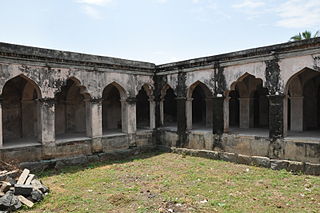
Attur Fort is a historic fort present in Attur in Salem district in the South Indian state of Tamil Nadu. The fort is located on the banks of river Vashista, 56 km (35 mi) away from Salem.The fort was built by a Palaiyakkarar chieftain Gatti Mudaliar dynasty under Madurai Nayaks, called Lakshmana Nayakan during the 17th century.
RamanaickenPalayam is a village panchayat in the Salem district in the Indian state of Tamil Nadu.
Belur is a first-grade town panchayat in the Vazhapadi taluk of Salem district, in Tamil Nadu, India.