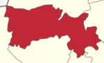
Thottiyam is a panchayat town in Tiruchirappalli district in the Indian state of Tamil Nadu. Thamilselvi Thirugnanam is the current President of Thottiyam. It is situated 60 km north-west of Tiruchirapalli on Tiruchy-Namakkal State Highway (SH-25) and further it connects Namakkal-Salem-Bangalore National Highway. It is located near the Kaveri River, about 12 km north-west of Musiri. Koranganatha Temple located in the outskirts of the town is a historic temple built during the Chola period in the 10th century.
Perundurai is a Special Grade Town Panchayat in Erode district in the Indian state of Tamil Nadu. Perundurai is the only special grade town panchayat among 42 in the district. Perundurai has developed as the industrial center with SIPCOT Industrial Estate and SEZ Complex. It is the Asia's Second largest SIPCOT.

Thiruvattar is a panchayat town in Kanyakumari district in the Indian state of Tamil Nadu.
Edappadi is one of the developing towns and a municipality in Salem district in the state of Tamil Nadu, India. Edappdi was once known for its thriving powerloom industry. The economy is diversified. The main modes of income are agriculture, lorry & heavy truck transport, granite, textile powerloom, entertainment and foundry.

Ettimadai is a suburb of Coimbatore in the state of Tamilnadu, India. Ettimadai is located between Palakkad city and Coimbatore on the NH47 near Tamil Nadu - Kerala border area. Ettimadai is one of the fast-growing south-western suburbs. It comes under the Coimbatore Corporation. The Amrita Vishwa Vidyapeetham University, along with its schools are situated here. There are other colleges such as Venkateshwara College of Business and Computer Applications, Nehru group of institution, Narayanana guru college of arts and technology.

Gummidipoondi is an industrial town in Chennai Metropolitan Region of Thiruvallur district in the Indian state of Tamil Nadu. Notably, it is the northernmost assembly constituency and settlement in the state of Tamil Nadu.
Thiruthavathurai (Lalgudi) is a town in Tiruchirapalli district in the Indian state of Tamil Nadu. The town of Lalgudi heads the Lalgudi taluk, Lalgudi division, Lalgudi Educational District, Lalgudi DSP and Lalgudi Constituency.
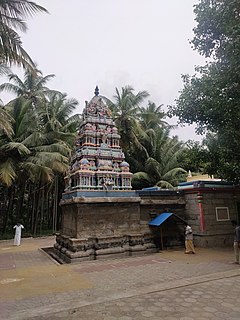
Musiri is a municipality in the Tiruchirappalli district in the Indian state of Tamil Nadu. It has an average elevation of 82 metres (269 feet).
Natrampalli is a selection grade panchayat town and Taluk in Tirupattur district in the Indian state of Tamil Nadu. The Natrampalli block is a revenue block in the Tirupattur district of Tamil Nadu, India.

Papanasam is a panchayat town in Thanjavur district in the Indian state of Tamil Nadu. It is located 25 kilometres (16 mi) from Thanjavur and 15 kilometres (9.3 mi) from Kumbakonam. The name literally translates to "Destruction of Sins" in the Tamil language. It is the suburban region of Kumbakonam.
Periya Negamam is a panchayat town in Coimbatore district in the southern Indian State of Tamil Nadu. It comes under Pollachi Taluk and pollachi Assembly constituency. Negamam used to be a popular small town serving the commercial and transport needs of many small villages around it until 1980s. With the arrival of frequent city buses to Pollachi and Udumalpet as transportation mode, growth of Negamam remained stunted. Weekly market on Tuesday used to be a big crowd puller.

Sankagiri or Sankari is a panchayat town in Salem district in the Indian state of Tamil Nadu. It is situated on the National Highway 544, on the Coimbatore - Salem section.

Tharamangalam is a Municipality in Salem district in the Indian state of Tamil Nadu.
Thiruporur is a panchayat town in Chengalpattu district in the Indian state of Tamil Nadu. The Thiruporur Kandaswamy temple is situated in the center of the town. There is a large temple tank in the vicinity of the temple. Thiruporur is located on Old Mahabalipuram Road and is flanked by Kelambakkam on one side and Alathur Pharmaceutical Industrial Estate on the other side, both of which are also on Old Mahabalipuram Road.
Thondamuthur is a suburb of Coimbatore city in the Indian state of Tamil Nadu. It comes under the Coimbatore Corporation. Thondamuthur is located 15 km west from the District headquarters Coimbatore, there are three routes available to reach Thondamuthur, through Vadavalli (15 km), through Perur (15 km), through Gandhi park, Vedapatti (14 km). Thondamuthur is the residential area. There is very high rise in population due to the development of many residential plots, apartments and many people reside here because the place is well connected with city centre through many routes and they can easily commute daily from Thondamuthur. The climate of Thondamuthur is very pleasant, low pollution, and many tourist spots like kovai couttralm, Velliangiri hills, Isha Foundation, Siruvani hills, Vaidehi falls are situated near Thondamuthur. People can taste World's second tastiest water Siruvani here.
Vadipatti is a panchayat town in the Madurai district in the Indian state of Tamil Nadu. Population of the town is 21,833. The famous Festival for Bull are "Jallikattu","Manju virattu" or "Erudhukattu Vizha". The major "Jallikattu Protest" happened in the surroundings of this town.
Vellalore is a panchayat town in Coimbatore district in the Indian state of Tamil Nadu. It is a southern suburb of the city. It is at 12 km east of Townhall, the centre of the city Coimbatore. It is situated on the southern bank of Noyyal river.

Thiruppuvanam is a town in Manamadurai Constituency and also Manamadurai division in the Indian state of Tamil Nadu.

Sendamangalam also known as Senthamangalam is a town panchayat in the Indian state of Tamil Nadu is situated in Namakkal District.
Sendamangalam is a Taluk in the Indian state of Tamil Nadu is situated in Namakkal District.