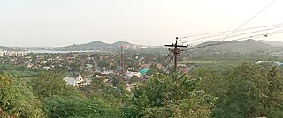
Thiruneermalai is a neighborhood in the city of Tambaram, situated within the Chennai Metropolitan Area, Tamil Nadu, India.
Chinnasekkadu is a neighbourhood of Chennai in Chennai district in the state of Tamil Nadu, India. Chinnasekkadu used to be a town panchayat in Thiruvallur district. In 2011, Chinnasekkadu town panchayat was merged with Chennai Corporation. Chinnasekkadu comes under ward 29 in Zone 3(Madhavaram) of Chennai Corporation.

Desur is a Town panchayat in Tiruvanamalai district in the Indian state of Tamil Nadu.

Devarshola is a panchayat town in The Nilgiris district in the state of Tamil Nadu, India.Devarshola comes under the administration of Gudalur revenue division and the taluk of Gudalur. It is one of the major tourist attractions in gudalur forest division and nearby to Mudumalai, Bandipur and Wayanad National parks. The state highway SH-98 Passing through the town which connects Gudalur and Sulthan Bathery.
Ezhudesam is a town panchayat in Kanniyakumari district in the state of Tamil Nadu, India.

Gummidipoondi is an industrial town in Chennai Metropolitan Region of Thiruvallur district in the Indian state of Tamil Nadu. Notably, it is the northernmost assembly constituency and settlement in the state of Tamil Nadu.

Injambakkam is a locality in the south of Chennai in the Indian state of Tamil Nadu. Being a part of the Walajabad block of the district, its panchayat is part of Walajabad panchayat union. Injambakkam is located along the ECR.
Kaliakkavilai is a town panchayat in Kanyakumari district in the Indian state of Tamil Nadu, close to the Tamil Nadu-Kerala border. It lies on the Kochi-Thiruvananthapuram-Kanyakumari National highway 47.
Krishnasamudram is a census town in Tiruchirappalli district in the Indian state of Tamil Nadu.
Nallur (Nalloor) is a panchayat town in Kanniyakumari district in the Indian state of Tamil Nadu.
Naranammalpuram is a panchayat town in Tirunelveli district in the Indian state of Tamil Nadu.
Naravarikuppam is a town in Thiruvallur district in the Indian state of Tamil Nadu.
Natrampalli is a selection grade panchayat town and Taluk in Tirupattur district in the Indian state of Tamil Nadu. The Natrampalli block is a revenue block in the Tirupattur district of Tamil Nadu, India.
Neyyoor is a panchayat town in Kanniyakumari district in the Indian state of Tamil Nadu.
Palavakam is a locality in the south of Chennai and census town in Chennai district in the Indian state of Tamil Nadu. It is located on the East Coast Road about 6 km south of Adyar.
Peerkankaranai is a neighborhood in the city of Tambaram, situated within the Chennai Metropolitan Area, Tamil Nadu, India.
Thevaram is a town in Theni district in the Indian state of Tamil Nadu. Thevaram is located in Tamil Nadu near on border of Kerala at the Eastern side foot-hill of the Western Ghats. It is connected with State Highway SH100.
Thiruporur is a panchayat town in Chengalpattu district in the Indian state of Tamil Nadu. The Thiruporur Kandaswamy temple is situated in the center of the town. There is a large temple tank in the vicinity of the temple. Thiruporur is located on Old Mahabalipuram Road and is flanked by Kelambakkam on one side and Alathur Pharmaceutical Industrial Estate on the other side, both of which are also on Old Mahabalipuram Road.
Vengathur is a census town in Thiruvallur district in the Indian state of Tamil Nadu.
Orathanad is a town in Thanjavur district of the Indian state of Tamil Nadu. It is recognised as a Town Panchayat. It is located at a distance of 33 km from Thanjavur and 23 km from Mannargudi. The town is surrounded by vast agricultural lands.


