Saint Anthony Falls, or the Falls of Saint Anthony, northeast of downtown Minneapolis, Minnesota, was the only natural major waterfall on the Upper Mississippi River. The natural falls were replaced by a concrete overflow spillway after it partially collapsed in 1869. Later, in the 1950s and 1960s, a series of locks and dams was constructed to extend navigation to points upstream.

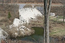
The St. Francis Dam was a curved concrete gravity dam, built to create a large regulating and storage reservoir for the city of Los Angeles, California. The reservoir was an integral part of the city's Los Angeles Aqueduct water supply infrastructure. It was located in San Francisquito Canyon of the Sierra Pelona Mountains, about 40 miles (64 km) northwest of downtown Los Angeles, and approximately 10 miles (16 km) north of the present day city of Santa Clarita.

The Johnstown Flood occurred on Friday, May 31, 1889, after the catastrophic failure of the South Fork Dam, located on the south fork of the Little Conemaugh River, 14 miles (23 km) upstream of the town of Johnstown, Pennsylvania. The dam broke after several days of extremely heavy rainfall, releasing 14.55 million cubic meters of water. With a volumetric flow rate that temporarily equaled the average flow rate of the Mississippi River, the flood killed more than 2,200 people and accounted for $17 million of damage.

The 1971 San Fernando earthquake occurred in the early morning of February 9 in the foothills of the San Gabriel Mountains in southern California. The unanticipated thrust earthquake had a magnitude of 6.5 on the scale, and a maximum Mercalli intensity of XI (Extreme). The event was one in a series that affected the Los Angeles area in the late 20th century. Damage was locally severe in the northern San Fernando Valley and surface faulting was extensive to the south of the epicenter in the mountains, as well as urban settings along city streets and neighborhoods. Uplift and other effects affected private homes and businesses.

Brandywine Creek is a tributary of the Christina River in southeastern Pennsylvania and northern Delaware in the United States. The Lower Brandywine is 20.4 miles (32.8 km) long and is a designated Pennsylvania Scenic River with several tributary streams. The East Branch and West Branch of the creek originate within 2 miles (3 km) of each other on the slopes of Welsh Mountain in Honey Brook Township, Pennsylvania, about 20 miles (32 km) northwest of their confluence.

The South Fork Fishing and Hunting Club was a Pennsylvania corporation which operated an exclusive and secretive retreat at a mountain lake near South Fork, Pennsylvania, for more than fifty extremely wealthy men and their families. The club was the owner of the South Fork Dam, which failed during an unprecedented period of heavy rains, resulting in the disastrous Johnstown Flood on May 31, 1889.

Penn Valley is an unincorporated community located within Lower Merion Township, Pennsylvania. Penn Valley residents share a zip code with Merion, Narberth, or Wynnewood because the town does not have its own post office. However, Penn Valley is a distinct community whose civic association demarcates the town's boundaries with iconic signs featuring William Penn and a farmhouse in blue or red on white, dating from the town's incorporation in 1930.

Pennypack Creek is a 22.6-mile-long (36.4 km) creek in southeastern Pennsylvania in the United States. It runs southeast through lower Bucks County, eastern Montgomery County and the northeast section of Philadelphia, before emptying into the Delaware River.
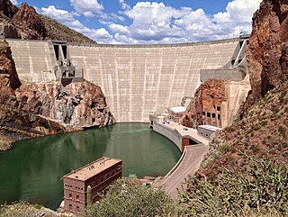
Theodore Roosevelt Dam is a dam on the Salt River located northeast of Phoenix, Arizona. The dam is 357 feet (109 m) high and forms Theodore Roosevelt Lake as it impounds the Salt River. Originally built between 1905 and 1911; the dam was renovated and expanded in 1989–1996. The dam is named after President Theodore Roosevelt. Serving mainly for irrigation, water supply, and flood control, the dam also has a hydroelectric generating capacity of 36 megawatts.

Penns Valley is an eroded anticlinal valley of the Pennsylvania ridge and valley geologic region of the Appalachian Mountain range. The valley is located in southern Centre County, Pennsylvania. Along with the Nittany Valley to the north and east, it is part of the larger Nittany Anticlinorium. It is bordered by Nittany Mountain to the north, the Seven Mountains range to the south, and connects to the larger Nittany Valley to the west. There are two smaller subordinate valleys typically associated with the greater valley: Georges Valley in the south, separated by Egg Hill, and Brush Valley in the north, separated by Brush Mountain.

The Lamar Boulevard Bridge is a historic arch bridge carrying Texas State Highway Loop 343 over Lady Bird Lake in downtown Austin, Texas, United States. The bridge features six open-spandrel concrete arches spanning 659 feet (201 m) and carries tens of thousands of vehicles daily across the lake. Completed in 1942, the Lamar Boulevard Bridge was the second permanent bridge to cross the Colorado River, and one of the last Art Deco-style open-spandrel concrete arch bridges built in Texas. The bridge was named an Austin Landmark in 1993 and added to the National Register of Historic Places in 1994.
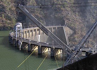
Calderwood Dam is a hydroelectric dam located along the Little Tennessee River in Blount and Monroe counties, in the U. S. state of Tennessee. Completed in 1930, the dam is owned and maintained by Tapoco, a subsidiary of the Aluminum Company of America (Alcoa), although the Tennessee Valley Authority controls the dam's reservoir levels from Fontana Dam further upstream. Calderwood Dam is named for Alcoa engineer Isaac Glidden Calderwood (1871–1941), who supervised much of the company's early Little Tennessee River operations.

The Bisbee Mill is a historic gristmill at 66 East Street in Chesterfield, Massachusetts. Located on the Dead Branch of the Westfield River, the mill complex includes a wood frame mill building, along with its former mill pond, impounded by a dam across the river, and a canal that brought river water to the mill for power. Also included on the property is the site of the Damon sawmill, which was established in 1761, and the Pierce cornmill, which occupied a site north of the Bisbee mill building in 1823. The Pierce mill was moved to the site, from an earlier one that may also be on the grounds of the Bisbee mill complex.

The North Canal Historic District of Lawrence, Massachusetts, encompasses the historic industrial heart of the city. It is centered on the North Canal and the Great Stone Dam, which provided the waterpower for its many mill complexes. The canal was listed on the National Register of Historic Places in 1975, while the district was first listed in 1984, and then expanded slightly in 2009.

The Ashland Dam and Spillway is a historic site at the north end of Ashland Reservoir in Ashland State Park in Ashland, Massachusetts. Ashland Reservoir was constructed in 1885, impounding a portion of Cold Spring Brook, a tributary of the Sudbury River. The dam and spillway were built as part of Boston's second major water works effort, which impounded large portions of the upper Sudbury River. They were listed on the National Register of Historic Places in 1990.

The Newlin Mill Complex, also referred to as The Newlin Grist Mill, is a water-powered gristmill on the west branch of Chester Creek near Concordville, Pennsylvania was built in 1704 by Nathaniel and Mary Newlin and operated commercially until 1941. During its three centuries of operation, the mill has been known as the Lower Mill, the Markham Mill, the Seventeen-O-Four Mill and the Concord Flour Mill. In 1958 the mill property was bought by E. Mortimer Newlin, restored and given to the Nicholas Newlin Foundation to use as a historical park. Water power is still used to grind corn meal which is sold on site. The park includes five historical buildings, which were added to the National Register of Historic Places in 1983, and 150 acres (61 ha) of natural woodland.

The Occum Hydroelectric Plant and Dam is a historic hydroelectric plant and dam north of Bridge Street on the west side of the Shetucket River in Norwich, Connecticut. The facility includes a rare surviving partial example of a large-scale dam built for a textile mill in 1865, and an early example of a hydroelectric power generation facility established in 1934. It is one of a small number of surviving hydroelectric plants in the state which was built before 1940. The complex was listed on the National Register of Historic Places in 1996.

Valley Paper Mill Chimney and Site is a historic chimney and archaeological site located at Alcove in Albany County, New York. It consists of the surviving 1844 Valley Paper Mill chimney and the site of the former straw pulp paper mill. The chimney is a rectangular brick tapered structure measuring 9.5 feet by 9.5 feet at its base and rising 110 feet. The mill was destroyed by fire in 1891 and the site leveled and filled. A significant portion of the site remains undisturbed from the time of the fire.

Nils F. Ambursen was a Norwegian-American civil engineer and inventor. He was the founder of Ambursen Hydraulic Construction Company and was known for his influential dam designs in the early 20th century.

Medlow Dam is a heritage-listed major gated concrete-walled arch dam across the Adams Creek in the Blue Mountains region, located at Beauchamp Road, Medlow Bath in the City of Blue Mountains local government area of New South Wales, Australia. The dam was designed and built in 1907 by the NSW Department of Public Works. The dam's purpose includes is primarily for the potable water supply of the upper Blue Mountains region. The impounded reservoir is called Medlow Bath Reservoir. The dam is also known as Medlow Bath Dam, Lake Medlow Dam, Adams Creek Dam and Medlow Bath Reservoir. The property is owned by Sydney Water, a state-owned corporation of the Government of New South Wales. The dam was added to the New South Wales State Heritage Register on 18 November 1999.