
Palakkad is one of the 14 districts in the Indian state of Kerala. It was carved out of the southeastern region of the former Malabar District on 1 January 1957. It is located at the central region of Kerala and is the second largest district in the state after Idukki. The city of Palakkad is the district headquarters. Palakkad is bordered on the northwest by the Malappuram district, on the southwest by the Thrissur district, on the northeast by Nilgiris district, and on the east by Coimbatore district of Tamil Nadu. The district is nicknamed "The granary of Kerala". Palakkad is the gateway to Kerala due to the presence of the Palakkad Gap, in the Western Ghats. The 2,383 m high Anginda peak, which is situated in the border of Palakkad district, Nilgiris district, and Malappuram district, in Silent Valley National Park, is the highest point of elevation in Palakkad district. Palakkad city is about 347 kilometres (216 mi) northeast of the state capital, Thiruvananthapuram.

Nelliyampathy is a hill station, located 60 kilometres (37 mi) from Palakkad, state of Kerala, India.
Vallangi is a village in the Palakkad district of Kerala, India. It forms a part of the Nemmara gram panchayat.
Alathur is a town, taluk and gram panchayat in Palakkad District, Kerala, India. It is the administrative headquarters of the Alathur Taluk and is situated about 24 km from the district headquarters Palakkad through National Highway 544.Gayathripuzha River, one of the tributary of Bharathapuzha, flows through Alathur. Alathur is one among the 29 Parliamentary Constituencies in Kerala. A Mini Civil Station is also located here which provides government related services.
Erimayur is a gram panchayat in the Palakkad district, state of Kerala, India. It is a local government organization that serves the villages of Erimayur-I and Erimayur-II.
Kavassery is a gram panchayat in the Palakkad district, state of Kerala, India. It is a very local government organisation that serves the villages of Kavasseri-I and Kavasseri-II. Its postal code is from 678543 to 678545.

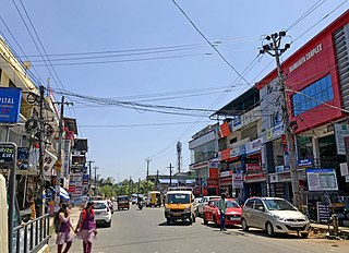
Cherpulassery is a town and municipality in the Palakkad district, of Kerala, India. Cherpulassery is often called the Sabarimala of Malabar as the famous Ayyappankavu temple is located here. The Puthanalakkal Bhagavathi temple and the Kalavela and Pooram associated with it is one of the largest festivals in the region. The town is located about 43 km (27 mi) west of the district headquarters at Palakkad on State Highway 53.

Kozhinjampara is a town in the Palakkad district, state of Kerala, India. It forms a part of the area administered by the Kozhinjampara gram panchayat.
Mannur is a village and gram panchayat in the Palakkad district, state of Kerala, India.
Palakkayam is a village in the Palakkad district, state of Kerala, India. It is administrated by the Thachampara grama panchayath. Palakkayam is about 16 km from Siruvani Dam Eco tourism spot, connected to Edakkurussi on Palakkad-Kozhikode National Highway about 33 km from Palakkad and 120 km from Kozhikode. Kanjirapuzha Dam, a masonry earth dam built for providing irrigation is located is located about 6 km from Palakkayam. The nearest airport is Coimbatore, about 100 km and nearest Rly Stn is Palakkad Jn, about 30 km.the nearest hospital assumption hospital kanjirapuzha.nearest school carmel hss palakkayam.
Pirayiri is a residential and commercial area in Palakkad city. It is located about 8 km (5.0 mi) from the city centre.It belongs to Pirayiri gram panchayat in the Palakkad district, state of Kerala, India.
Thiruvazhiyad is a village in Palakkad district in the state of Kerala, India. It forms a part of the Ayiloor gram panchayat.
Anakkara is a village and grama panchayat in Pattambi taluk, Palakkad district, Kerala, India. It is located on the southern bank of Bharathappuzha river. Anakkara is located about 8 km south of Kuttippuram town. It was a part of Ponnani taluk until 16 June 1969. The border Grama Panchayats of Anakkara are Kuttipuram and Irimbiliyam in Tirur Taluk, Thavanur, Kalady, and Vattamkulam in Ponnani taluk, and Parudur and Pattithara in Pattambi Taluk.
Nemmara is a gram panchayat in the Palakkad district, state of Kerala, India. It is the local government organisation that serves the villages of Nemmara and Vallanghy. It is also an intermediate panchayat, subordinate to the Palakkad zilla panchayat.

Agali is a village in Palakkad district in the state of Kerala, India. It forms a part of the Agali Grama Panchayat.
Ayiloor is a gram panchayat in the Palakkad district, state of Kerala, India. It is a local government organisation that serves the villages of Ayiloor, Kairady and Thiruvazhiyad.

Kannadi is a gram panchayat in the Palakkad district, state of Kerala, India. Third lulu mall in Kerala, Lulu International Shopping Mall, Palakkad is located in Kannadi. It is a local government organisation that serves the villages of Kannadi-I and Kannadi-II.
Kadampazhipuram is a gram panchayat in Palakkad district, state of Kerala, India. It is a local government organisation that serves the villages of Kadampazhipuram-I and Kadampazhipuram-II. The place is on the Palakkad - Cherpulassery Road.

Karimba is a gram panchayat in the Palakkad district, state of Kerala, India, near the National Highway 213. The largest town in Karimba panchayath is Kalladikode. It borders with Thachampara, Kongad, Katampazhipuram and Mundur. Recently, it was awarded the Nirmal Gram Title (sanitation). It is the local government organisation that serves the villages of Karimba-I and Karimba-II.
Palakkad District is one of the main centre of education in Kerala state India. It has Prominent Educational Institutions provide platform for various level of education. The district is home to the only Indian Institute of Technology in Kerala state. Palakkad District has three educational districts namely Palakkad, Ottappalam and Mannarkkad. There are several educational institutions working across the district. Government Victoria College, Palakkad, Government Engineering College, Sreekrishnapuram, NSS College of Engineering, Government Medical College, Palakkad, Chembai Memorial Government Music College, and many more higher level of educational institutions are located in Palakkad District.
