
Palakkad is one of the 14 districts in the Indian state of Kerala. It was carved out of the southeastern region of the former Malabar District on 1 January 1957. It is located at the central region of Kerala and is the second largest district in the state after Idukki. The city of Palakkad is the district headquarters. Palakkad is bordered on the northwest by the Malappuram district, on the southwest by the Thrissur district, on the northeast by Nilgiris district, and on the east by Coimbatore district of Tamil Nadu. The district is nicknamed "The granary of Kerala". Palakkad is the gateway to Kerala due to the presence of the Palakkad Gap, in the Western Ghats. The 2,383 m high Anginda peak, which is situated in the border of Palakkad district, Nilgiris district, and Malappuram district, in Silent Valley National Park, is the highest point of elevation in Palakkad district. Palakkad city is about 347 kilometres (216 mi) northeast of the state capital, Thiruvananthapuram.

Ottapalam is a town, taluk and municipality in the Palakkad District, Kerala, India. It is the administrative headquarters of the Ottapalam taluk. Ottapalam is located about 34 km (21 mi) from district headquarters Palakkad. Ottapalam is located along the banks of Bharathapuzha, second longest river of the state.

Nelliyampathy is a hill station, located 60 kilometres (37 mi) from Palakkad, state of Kerala, India.
Alathur is a town, taluk and gram panchayat in Palakkad District, Kerala, India. It is the administrative headquarters of the Alathur Taluk and is situated about 24 km from the district headquarters Palakkad through National Highway 544.Gayathripuzha River ,one of the tributary of Bharathapuzha, flows through Alathur. Alathur is one among the 29 Parliamentary Constituencies in Kerala. A Mini Civil Station is also located here which provides government related services.
Kannadipuzha River is one of the main tributaries of the Bharathapuzha River, the second-longest river in Kerala, south India.

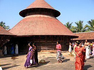
Kalpathi (Kalpathy) Ratholsavam is an annual Hindu Temple festival in the Kalpathy of Palakkad in Kerala state, south India. The festival is at the Sri Visalakshi Sametha Sri Viswanatha Swamy temple where the deities are Lord Siva and his consort Visalakshi, another name for Parvati.

Mangalam River is the main tributary of the river Gayathripuzha, which in turn is a tributary of Bharathapuzha, the second longest river in Kerala, India. It is around 30 km long in length, with its source from Nelliyampathi forests, and passing through Vadakkencherry, Kannambra, Puthucode, Padur, etc. and joining Gayathripuzha at Plazhi in the border of Thrissur and Palakkad districts.
Kannambra is a gram panchayat in the Palakkad district, state of Kerala, India. It is the local government organisation that serves the villages of Kannambra-I and Kannambra-II.
Kizhakkancherry is a gram panchayat in the Palakkad district, state of Kerala, India. It is a local government organisation that serves the villages of Kizhakkencheri-I and Kizhakkencheri-II. It was formed in the year of 1951 and is the fourth largest grama panchayath in Kerala. It covers an area of 112.56 km2 and comprises 22 wards. The boundaries are Vadakkencherry (north), Pananjeri (south), Vandazhy (east) and Kannambra (west). The village is located 37.4 km from the city of Palakkad and 34.9 km from Thrissur.

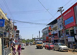
Mannarkkad, formerly known as Mannarghat, is a major municipal town in Palakkad district of the Indian state of Kerala. The Silent Valley National Park and the Attappadi Reserve Forest are located in Mannarkkad Taluk. Mannarkkad is situated 36 km away from district headquarters Palakkad on National Highway 966.

Palakkad, also known as Palghat, historically known as Palakkattussery, is a city and municipality in the Indian state of Kerala. It is the administrative headquarters of Palakkad District. Palakkad is the most densely populated municipality and the fourth-most densely populated city in the state. It was established before Indian independence under British rule and known by the name Palghat. Palakkad is famous for the ancient Palakkad Fort, which is in the heart of the city and was captured and rebuilt by Hyder Ali in 1766 which later fell into the hands of Zamorin in 1784. The city is about 347 kilometres (216 mi) northeast of the state capital, Thiruvananthapuram.

Palakkad Fort is an old fort situated in the heart of Palakkad city of Kerala state, southern India. It was recaptured and rebuilt grandly by Sultan Hyder Ali in 1766 A.D and remains one of the best-preserved forts in Kerala.

Chittur-Thathamangalam is a town and municipality in Palakkad district of Kerala State, India. It is the headquarters of Chittur taluk, 13 km (8.1 mi) south-east of Palakkad, on the banks of the Kannadipuzha, a major headstream of the Bharathapuzha, the second longest river in Kerala. A Mini Civil Station is also located here which provides government related services. It consists of two areas, Chittur and Thathamangalam which together form the municipality.
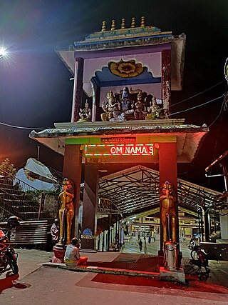
Sri Visalakshi Sametha Sri Viswanatha Swamy temple, popularly known as Kasi Viswanathaswamy Temple, or locally as kundukovil, is a famous Hindu temple located in the Kalpathy village of Palakkad in Kerala, India. It is the site of the annual Kalpathi Ratholsavam which is one of the most famous temple festivals of Kerala. This ancient temple nestles by the banks of the serene Kalpathy river. Dedicate to Lord Siva and his consort Visalakshi, it dates back to early fifteenth century. The similarity to the Varanasi Kashi Viswanatha temple on the banks of Ganges is responsible for the moniker kasiyil pakuthi kalpathy and the name Dakshina Kashi associated with this temple. The Temple is surrounded by the four Tamil Brahmin agraharams or traditional villages: New Kalpathy, Old Kalpathy, Chathapuram and Govindarajapuram.
Padur (or Padoor) is a village in Palakkad District, Kerala. There is a temple of Sree Panickanar where a yearly festival called Padur Vela is celebrated, which is well attended for Vela-Poorams in Palakkad.

Sivapuram is a village in Kannur district in the Indian state of Kerala.
Kollengode is one of the major towns in Palakkad district, Kerala, India. Kollengode Town is the headquarters of Kollengode Grama Panchayat and Kollengode Block Panchayat. Kollengode is one of the major tourist spots of Palakkad district. It is located about 26 km from Palakkad.
Eruvessi is a village in Irikkur Block Panchayat, Taliparamba Taluk, Kannur district in Kerala, India, around 50 kilometers from Kannur. It was ruled by Mannanar dynasty of Muthedath Aramana and Elayadath Aramana.
Angadippuram is a census town and major suburb of Perinthalmanna town, in the Malappuram District of Kerala. It was the capital of the powerful medieval kingdom of Valluvanad. Angadippuram is also known for Angadippuram Laterite, a notified geo-heritage monument. Angadippuram is famous for its two temples, the Thirumandhamkunnu Temple and the Tali Mahadeva Temple. Kozhikode - Palakkad National Highway 966 passes through the town and Angadipuram Railway Station is one of the major railway stations on the Nilambur - Shornur Line of Palakkad Division, Southern Railways. It is connected to the major cities Kochi and Thiruvananthapuram by this line.

Dhoni is situated around 15 Kilometers from Palakkad town in Kerala, India. Dhoni is named after a boat shaped rock on one of its hill, as boat in Malayalam is called "thoni". It is famous for Dhoni Waterfalls and the Western Ghat

