Thrikkadeeri-I | |
---|---|
village | |
Country | |
State | Kerala |
District | Palakkad |
Population (2001) | |
• Total | 12,666 |
Languages | |
• Official | Malayalam, English |
Time zone | UTC+5:30 (IST) |
PIN | 6XXXXX |
Vehicle registration | KL- |
Thrikkadeeri -I is a village in Palakkad district in the state of Kerala, India. [1]
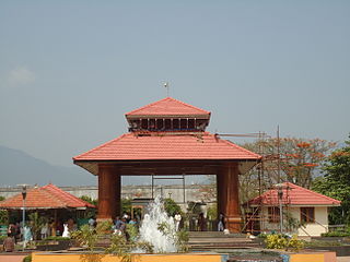
Palakkad District is one of the 14 districts of the Indian state of Kerala. Also, it is the largest district in Kerala from 2006. The city of Palakkad is the district headquarters. Palakkad is bordered on the northwest by the Malappuram District, on the southwest by the Thrissur District, on the northeast by The Nilgiris District, and on the east by Coimbatore district of Tamil Nadu. The district is 24.4% urbanized according to the census of 2011. The district is nicknamed "the granary of Kerala" and "Rice bowl of Kerala".
Kerala is a state on the southwestern Malabar Coast of India. It was formed on 1 November 1956, following passage of the States Reorganisation Act, by combining Malayalam-speaking regions. Spread over 38,863 km2 (15,005 sq mi), Kerala is the twenty-third largest Indian state by area. It is bordered by Karnataka to the north and northeast, Tamil Nadu to the east and south, and the Lakshadweep Sea to the west. With 33,387,677 inhabitants as per the 2011 Census, Kerala is the thirteenth-largest Indian state by population. It is divided into 14 districts with the capital being Thiruvananthapuram. Malayalam is the most widely spoken language and is also the official language of the state.
India is a country in South Asia. It is the seventh-largest country by area, the second-most populous country, and the most populous democracy in the world. Bounded by the Indian Ocean on the south, the Arabian Sea on the southwest, and the Bay of Bengal on the southeast, it shares land borders with Pakistan to the west; China, Nepal, and Bhutan to the north; and Bangladesh and Myanmar to the east. In the Indian Ocean, India is in the vicinity of Sri Lanka and the Maldives; its Andaman and Nicobar Islands share a maritime border with Thailand and Indonesia.
As of 2001 [update] India census, Thrikkadeeri -I had a population of 12666 with 5825 males and 6841 females. [1]
A census is the procedure of systematically acquiring and recording information about the members of a given population. This term is used mostly in connection with national population and housing censuses; other common censuses include traditional culture, business, supplies, and traffic censuses. The United Nations defines the essential features of population and housing censuses as "individual enumeration, universality within a defined territory, simultaneity and defined periodicity", and recommends that population censuses be taken at least every 10 years. United Nations recommendations also cover census topics to be collected, official definitions, classifications and other useful information to co-ordinate international practices.
Rampurhat II is a community development block that forms an administrative division in Rampurhat subdivision of Birbhum district in the Indian state of West Bengal.
Arambakkam is a village in the Tiruvallur district of Tamil Nadu, India. It is located in the Gummidipoondi taluk.
Sreekrishnapuram is a village in the Palakkad district in the state of Kerala, India.
Thrikkadeeri -II is a village in Palakkad district in the state of Kerala, India.
Amta I is a city and community development block that forms an administrative division in Uluberia subdivision of Howrah district in the Indian state of West Bengal.
Khanakul I is a community development block that forms an administrative division in Arambag subdivision of Hooghly district in the Indian state of West Bengal.
Goghat I is a community development block that forms an administrative division in Arambag subdivision of Hooghly district in the Indian state of West Bengal.
Bhagawangola I is a community development block that forms an administrative division in Lalbag subdivision of Murshidabad district in the Indian state of West Bengal.
Habra I is a community development block that forms an administrative division in Barasat Sadar subdivision of North 24 Parganas district in the Indian state of West Bengal.
Basirhat I is a community development block that forms an administrative division in Basirhat subdivision of North 24 Parganas district in the Indian state of West Bengal.
Barrackpore I is a community development block that forms an administrative division in the Barrackpore subdivision of North 24 Parganas district in the Indian state of West Bengal.
Beldanga I is a community development block that forms an administrative division in Barhampur subdivision of Murshidabad district in the Indian state of West Bengal.
Raninagar I is a community development block that forms an administrative division in Domkol subdivision of Murshidabad district in the Indian state of West Bengal.
Raninagar II is a community development block that forms an administrative division in Domkol subdivision of Murshidabad district in the Indian state of West Bengal.
Chanditala I is a community development block that forms an administrative division in Srirampore subdivision of Hooghly district in the Indian state of West Bengal.
Murarai II is a community development block that forms an administrative division in Rampurhat subdivision of Birbhum district in the Indian state of West Bengal.
Elappully is a gram panchayat in the Palakkad district, state of Kerala, India. It is a local government organisation that serves the villages of Elappully-I and Elappully-II.
Kannadi is a gram panchayat in the Palakkad district, state of Kerala, India. It is a local government organisation that serves the villages of Kannadi-I and Kannadi-II.
Karimpuzha is a gram panchayat in the Palakkad district, state of Kerala, India. It is a local government organisation that serves the villages of Karimpuzha-I and Karimpuzha-II.
Elavur is a village in the Tiruvallur district of Tamil Nadu, India. It is located in the Gummidipoondi taluk. It is located near Gummidipoondi.
This article related to a location in Palakkad district, Kerala, India is a stub. You can help Wikipedia by expanding it. |