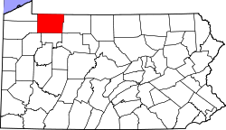
Backup Corners, Pennsylvania

Last updated

Backup Corners, Pennsylvania
USA Pennsylvania location map.svg
Red pog.svg
Backup Corners, Pennsylvania
Usa edcp location map.svg
Red pog.svg
Backup Corners, Pennsylvania
Coordinates: 41°55′02″N79°09′00″W / 41.91722°N 79.15000°W / 41.91722; -79.15000
Country United States
State Pennsylvania
County Warren County
Elevation
1,247 ft (380 m)
Time zone UTC-5 (EST)
  Summer (DST) UTC-4 (EDT)
GNIS feature ID1168563 [1]

Backup Corners is an unincorporated community in Warren County, Pennsylvania, United States. [1]

Conewango Creek flows on the eastern boundary of the settlement.

A now-abandoned track of the Dunkirk, Allegheny Valley and Pittsburgh Railroad, completed in the early 1870s, passes through the settlement. [2] [3]

Related Research Articles

<span class="mw-page-title-main">Allegheny River</span> River in Pennsylvania and New York, United States

The Allegheny River is a 325-mile-long (523 km) headwater stream of the Ohio River that is located in western Pennsylvania and New York in the United States. It runs from its headwaters just below the middle of Pennsylvania's northern border, northwesterly into New York, then in a zigzag southwesterly across the border and through Western Pennsylvania to join the Monongahela River at the Forks of the Ohio at Point State Park in Downtown Pittsburgh, Pennsylvania.

Cassadaga is a village in Chautauqua County, New York, United States. The village is located within the northeast corner of the town of Stockton, east of the hamlet of Stockton, south of and immediately adjacent to Lily Dale in the town of Pomfret, and north of the village of Sinclairville. As of the 2020 census, the population of Cassadaga was 569.

<span class="mw-page-title-main">Shaler Township, Allegheny County, Pennsylvania</span> Township in Pennsylvania, United States

Shaler Township is a township in Allegheny County in the U.S. state of Pennsylvania. It consists of much of the community of Glenshaw and several neighboring communities. The population was 28,757 at the 2010 census. It is part of the Pittsburgh metropolitan area.

<span class="mw-page-title-main">Allegheny Portage Railroad</span> National Historic Site of the United States

The Allegheny Portage Railroad was the first railroad constructed through the Allegheny Mountains in central Pennsylvania. It operated from 1834 to 1854 as the first transportation infrastructure through the gaps of the Allegheny that connected the midwest to the eastern seaboard across the barrier range of the Allegheny Front. Approximately 36 miles (58 km) long overall, both ends connected to the Pennsylvania Canal, and the system was primarily used as a portage railway, hauling river boats and barges over the divide between the Ohio and the Susquehanna Rivers. Today, the remains of the railroad are preserved within the Allegheny Portage Railroad National Historic Site operated by the National Park Service.

<span class="mw-page-title-main">Western Pennsylvania</span> Region of Pennsylvania, United States

Western Pennsylvania is a region in the Commonwealth of Pennsylvania encompassing the western third of the state. Pittsburgh is the region's principal city, with a metropolitan area population of about 2.4 million people, and serves as its economic and cultural center. Erie, Altoona, and Johnstown are its other metropolitan centers. As of the 2010 census, Western Pennsylvania's total population is nearly 4 million.

<span class="mw-page-title-main">Genesee Valley Canal</span> Former waterway in New York, U.S.

The Genesee Valley Canal is a former canal that operated in central New York between 1840 and 1878. It ran for a length of 124 miles, passing through 106 locks. Its course was later used by the Genesee Valley Canal Railroad and today comprises portions of the Genesee Valley Greenway.

The Genesee Valley Canal Railroad was a part of the Pennsylvania Railroad system in western New York. It was built on the former Genesee Valley Canal alignment.

<span class="mw-page-title-main">Rennerdale, Pennsylvania</span> Census-designated place in Pennsylvania, United States

Rennerdale is an unincorporated community and census-designated place in Collier Township, Allegheny County, Pennsylvania, United States, about 9 miles (14 km) southwest of Pittsburgh. As of the 2020 census it had a population of 1,103.

The Chartiers branch of the Pennsylvania Railroad followed Chartiers Creek from Carnegie to Washington, passing Bridgeville, present day Southpointe, and Canonsburg. It is 23.6 miles (38.0 km) long and construction was completed in 1867 and is still in use today, after passing through at least seven different owners.

The Dunkirk, Allegheny Valley and Pittsburgh Railroad is a historic railroad company that operated in Pennsylvania and New York.

<span class="mw-page-title-main">Allegheny Valley Railroad</span> Class III railroad that operates in Western Pennsylvania

The Allegheny Valley Railroad is a class III railroad that operates in Western Pennsylvania, and is owned by Carload Express, Inc.

<span class="mw-page-title-main">Turtle Creek (Monongahela River tributary)</span> River in Pennsylvania, United States

Turtle Creek is a 21.1-mile-long (34.0 km) tributary of the Monongahela River that is located in Allegheny and Westmoreland counties in the U.S. state of Pennsylvania. Situated at its juncture with the Monongahela is Braddock, Pennsylvania, where the Battle of the Monongahela was fought in 1755.

The Kiski Junction Railroad was a short-line railroad that operated in Western Pennsylvania near the city of Pittsburgh. The railroad was based in the small community of Schenley which is situated at the point where the Kiskiminetas River flows into the Allegheny River. The KJR functioned as both a freight hauler and a tourist railroad. The railroad suspended all rail operations after the 2016 season and was officially closed and abandoned in 2021.

Eidenau is an unincorporated community in Jackson Township, Butler County, Pennsylvania, United States.

<span class="mw-page-title-main">Oil Creek and Titusville Railroad</span>

The Oil Creek and Titusville Railroad is a tourist railroad that runs from Titusville to Rynd Farm north of Oil City in the U.S. state of Pennsylvania. The Oil Creek and Titusville Lines is the designated operator of the railroad, as well as the freight carrier on the line.

<span class="mw-page-title-main">John P. Saylor Trail</span>

The John P. Saylor Trail is a 17.5-mile (28.2 km) hiking trail system in southwestern Pennsylvania, consisting of two loops with a short cross-connector trail, through Gallitzin State Forest in Somerset County. The trail is named after Congressman John P. Saylor, who sponsored the National Scenic Trails Act while supporting national wilderness preservation. The main loop, which can be reached from the trailhead, is 12.0 miles around. The south loop, which cannot be reached directly by car, can be combined with the main loop and the short cross-connector, for a "figure-8" hike of 17.5 miles.

<span class="mw-page-title-main">Westmoreland Heritage Trail</span>

The Westmoreland Heritage Trail is a partially completed rail trail in southwestern Pennsylvania. As of 2019, 18.0 miles of the 21.9 planned miles of trail are complete, including an 8.7 mile section from Saltsburg to the fringe of Delmont as well as a 9.3 mile section from Trafford to Export.

The Pennsylvania Petroleum Railroad was a railroad in Pennsylvania originally chartered in 1871, during the Pennsylvania oil rush. Intended to provide an additional outlet from the Pennsylvania oil fields to Erie, Pennsylvania, it graded about ten miles of line in 1872, but was then caught up in the collapse of the Atlantic and Great Western Railroad, which halted the project. The company was foreclosed and reorganized under new names many times, but accomplished relatively little. It laid a short segment of line in 1890 in Titusville, Pennsylvania which was leased to a subsidiary of the New York Central to be used as a siding to a tannery. Further construction took place in 1913 with the idea of opening it as an electric railway to Cambridge Springs, but this, too, was never completed.

References

  1. 1 2 U.S. Geological Survey Geographic Names Information System: Backup Corners
  2. "The Dunkirk, Allegheny Valley & Pittsburgh Railroad". Abandoned Rails.com. Retrieved October 27, 2016.
  3. Springirth, Kenneth C.; Weber, David L. (2011). Oil Creek and Titusville Railroad. Arcadia. p. 59. ISBN   9780738575933.