Sheffield, Pennsylvania

Last updated

Sheffield
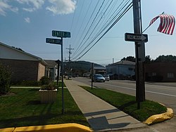
PA 666 in Sheffield.jpg
Route 666 through downtown Sheffield, September 2017
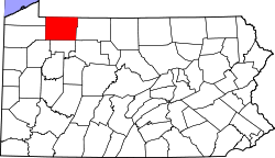
Map of Sheffield, Warren County, Pennsylvania Highlighted.png
Location of Sheffield in Warren County
Coordinates: 41°42′15″N79°2′2″W / 41.70417°N 79.03389°W / 41.70417; -79.03389
CountryUnited States
State Pennsylvania
County Warren
Area
  Total1.6 sq mi (4 km2)
Population
 (2010)
  Total1,123
  Density700/sq mi (270/km2)
Time zone UTC-4 (EST)
  Summer (DST) UTC-5 (EDT)
ZIP code
16347 [1]
Area code 814

Sheffield is a census-designated place (CDP) within Sheffield Township in southeastern Warren County, Pennsylvania, United States. It is named after Sheffield, England. The population was 1,123 as of the 2010 census.

Contents

Geography

Sheffield is located at 41°42′15″N79°2′2″W / 41.70417°N 79.03389°W / 41.70417; -79.03389 (41.704246, -79.034022). [2]

According to the United States Census Bureau, the CDP has a total area of 1.7 square miles (4.4 km2), all land.

Demographics

As of the 2010 census, [3] there were 1,123 people, 510 households, and 344 families residing in the CDP. The population density was 701.9 people per square mile (271.0 people/km2). There were 566 housing units at an average density of 327.4 per square mile (126.4/km2). The racial makeup of the CDP was 98.66% White, 0.39% African American, 0.08% Native American, 0.08% Asian, 0.32% from other races, and 0.47% from two or more races. Hispanic or Latino of any race were 0.63% of the population.

There were 510 households, out of which 30.4% had children under the age of 18 living with them, 52.5% were married couples living together, 11.8% had a female householder with no husband present, and 32.4% were non-families. 27.3% of all households were made up of individuals, and 14.1% had someone living alone who was 65 years of age or older. The average household size was 2.45 and the average family size was 2.96.

In the CDP, the population was spread out, with 24.6% under the age of 18, 6.9% from 18 to 24, 26.0% from 25 to 44, 24.8% from 45 to 64, and 17.6% who were 65 years of age or older. The median age was 40 years. For every 100 females, there were 92.7 males. For every 100 females age 18 and over, there were 87.5 males.

The median income for a household in the CDP was $36,307, and the median income for a family was $46,912. Males had a median income of $29,886 versus $18,750 for females. The per capita income for the CDP was $16,751. About 7.8% of families and 11.4% of the population were below the poverty line, including 18.1% of those under age 18 and 7.2% of those age 65 or over.

See also

Related Research Articles

<span class="mw-page-title-main">Paukaa, Hawaii</span> Census-designated place in Hawaii, U.S.

Paukaʻa is a census-designated place (CDP) in Hawaii County, Hawaii, United States. The population was 425 at the 2010 census, down from 495 at the 2000 census. The ZIP code is 96720.

<span class="mw-page-title-main">Firthcliffe, New York</span> CDP in New York, United States

Firthcliffe is a hamlet in Orange County, New York United States. The population was 5,022 at the 2020 Census. It is part of the Poughkeepsie–Newburgh–Middletown, NY Metropolitan Statistical Area as well as the larger New York–Newark–Bridgeport, NY-NJ-CT-PA Combined Statistical Area.

<span class="mw-page-title-main">Lenape Heights, Pennsylvania</span> Census-designated place in Pennsylvania, United States

Lenape Heights is a census-designated place (CDP) in Armstrong County, Pennsylvania, United States. The population was 1,144 at the 2020 census.

<span class="mw-page-title-main">Nixon, Pennsylvania</span> Census-designated place in Pennsylvania, United States

Nixon is a census-designated place (CDP) in Penn Township, Butler County, Pennsylvania, United States. The population was 1,373 at the 2010 census.

<span class="mw-page-title-main">Pine Glen, Pennsylvania</span> Census-designated place in Pennsylvania, United States

Pine Glen is an unincorporated community and census-designated place (CDP) in Centre County, Pennsylvania, United States. It is part of the State College, Pennsylvania Metropolitan Statistical Area. It is part of Burnside Township. The population was 190 at the 2010 census.

<span class="mw-page-title-main">Canadohta Lake, Pennsylvania</span> Census-designated place in Pennsylvania, United States

Canadohta Lake, otherwise known as “Cam-adohta Lake”, is a census-designated place (CDP) in Crawford County, Pennsylvania, United States. The population was 516 at the 2010 census. The current mayor is John Rudolchick.

<span class="mw-page-title-main">Geneva, Pennsylvania</span> Census-designated place in Pennsylvania, United States

Geneva is a census-designated place in Crawford County, Pennsylvania, United States. The population was 109 at the 2010 census.

<span class="mw-page-title-main">Guys Mills, Pennsylvania</span> Census-designated place in Pennsylvania, United States

Guys Mills is a census-designated place in Crawford County, Pennsylvania, United States. The population was 124 at the 2010 census.

<span class="mw-page-title-main">Lincolnville, Pennsylvania</span> Census-designated place in Pennsylvania, United States

Lincolnville is a census-designated place in Crawford County, Pennsylvania, United States. The population was 96, as per the 2010 census.

<span class="mw-page-title-main">Riceville, Pennsylvania</span> Census-designated place in Pennsylvania, United States

Riceville is a census-designated place in Crawford County, Pennsylvania, United States. The population was 68 at the 2010 census.

<span class="mw-page-title-main">Oliver, Pennsylvania</span> Census-designated place in Pennsylvania, United States

Oliver is a census-designated place (CDP) in Fayette County, Pennsylvania, United States. The population was 2,535 at the 2010 census, down from 2,925 at the 2000 census. Oliver is located in North Union Township.

<span class="mw-page-title-main">Republic, Pennsylvania</span> Census-designated place in Pennsylvania, United States

Republic is an unincorporated community and census-designated place (CDP) in Fayette County, Pennsylvania, United States. The population was 1,096 at the 2010 census, down from 1,396 at the 2000 census. The community is in Redstone Township.

Jacksonville is a census-designated place (CDP) in Indiana County, Pennsylvania, United States. The population was 637 at the 2010 census. It was formerly an independent borough, until January 1, 1993 when it was returned to Black Lick Township, Pennsylvania.

<span class="mw-page-title-main">East Berwick, Pennsylvania</span> Census-designated place in Pennsylvania, United States

East Berwick is a census-designated place (CDP) in Salem Township, Luzerne County, Pennsylvania, United States. The population was 2,007 at the 2010 census.

<span class="mw-page-title-main">Klingerstown, Pennsylvania</span> CDP in Pennsylvania, United States

Klingerstown is a census-designated place (CDP) in Upper Mahantongo Township, Schuylkill County, Pennsylvania, United States. As of the 2000 census, the CDP population was 102.

Hasson Heights is a census-designated place (CDP) in Venango County, Pennsylvania, United States. The population was 1,351 at the 2010 census.

Seneca is a census-designated place (CDP) in Venango County, Pennsylvania, United States. As of the 2000 census, the CDP population was 966.

Woodland Heights is a census-designated place (CDP) in Venango County, Pennsylvania, United States. The population was 1,402 at the 2000 census.

<span class="mw-page-title-main">Warren South, Pennsylvania</span> Census-designated place in Pennsylvania, United States

Warren South is a former census-designated place (CDP) in Warren County, Pennsylvania, United States. The population was 1,651 at the 2000 census.

<span class="mw-page-title-main">Fredericktown-Millsboro, Pennsylvania</span> Former CDP in Pennsylvania, United States

Fredericktown-Millsboro was a census-designated place (CDP) in East Bethlehem Township, Washington County, Pennsylvania, United States. The population was 1,094 at the 2000 census. For the 2010 census the area was split into two CDPs, Fredericktown and Millsboro.

References

  1. "Sheffield PA ZIP Code". zipdatamaps.com. 2023. Retrieved October 31, 2023.
  2. "US Gazetteer files: 2010, 2000, and 1990". United States Census Bureau. February 12, 2011. Retrieved April 23, 2011.
  3. "U.S. Census website". United States Census Bureau . Retrieved January 31, 2008.