This article needs additional citations for verification .(October 2013) |
Starbrick, Pennsylvania | |
|---|---|
 | |
| Country | United States |
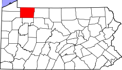
| State | Pennsylvania |
| County | Warren |
| Population (2010) | |
• Total | 522 |
| Time zone | UTC-5 (Eastern (EST)) |
| • Summer (DST) | UTC-4 (EDT) |
| ZIP code | 16365 [1] |
| Area code | 814 |
Starbrick is a census-designated place [2] located in Conewango Township, Warren County in the state of Pennsylvania, United States. The community is located along the famous U.S. Route 6, just to the west of the city of Warren. As of the 2010 census [3] the population was 522 residents.