Bear Lake, Pennsylvania

Last updated
Bear Lake, Pennsylvania
Warren County Pennsylvania Incorporated and Unincorporated areas Bear Lake Highlighted.svg
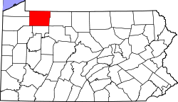
Location of Bear Lake in Warren County, Pennsylvania.
USA Pennsylvania location map.svg
Red pog.svg
Bear Lake, Pennsylvania
Location of Bear Lake in Pennsylvania
Coordinates: 41°59′34″N79°30′20″W / 41.99278°N 79.50556°W / 41.99278; -79.50556 Coordinates: 41°59′34″N79°30′20″W / 41.99278°N 79.50556°W / 41.99278; -79.50556
CountryUnited States
State Pennsylvania
County Warren
Founded1887
Government
  MayorTroyce Jehorek
Area
[1]
  Total0.69 sq mi (1.79 km2)
  Land0.69 sq mi (1.79 km2)
  Water0.00 sq mi (0.00 km2)
Population
 (2020) [2]
  Total148
  Density214.49/sq mi (82.78/km2)
Time zone UTC-4 (EST)
  Summer (DST) UTC-5 (EDT)
ZIP code
16402
Area code 814

Bear Lake is a borough in Warren County, Pennsylvania, United States. The population was 193 at the 2000 census.

Contents

Geography

Bear Lake is located at 41°59′34″N79°30′20″W / 41.99278°N 79.50556°W / 41.99278; -79.50556 (41.992823, -79.505610). [3]

According to the United States Census Bureau, the borough has a total area of 0.7 square miles (1.8 km2), all land.

Demographics

Historical population
CensusPop.
1880 154
1890 313103.2%
1900 275−12.1%
1910 221−19.6%
1920 2419.0%
1930 162−32.8%
1940 21432.1%
1950 23911.7%
1960 2608.8%
1970 2818.1%
1980 249−11.4%
1990 193−22.5%
2000 1930.0%
2010 164−15.0%
2020 148−9.8%
Sources: [4] [5] [6] [2]

As of the census [5] of 2000, there were 193 people, 66 households, and 55 families residing in the borough. The population density was 277.1 people per square mile (106.5/km2). There were 74 housing units at an average density of 106.3 per square mile (40.8/km2). The racial makeup of the borough was 100.00% White. Hispanic or Latino of any race were 0.52% of the population.

There were 66 households, out of which 39.4% had children under the age of 18 living with them, 72.7% were married couples living together, 10.6% had a female householder with no husband present, and 15.2% were non-families. 12.1% of all households were made up of individuals, and 4.5% had someone living alone who was 65 years of age or older. The average household size was 2.92 and the average family size was 3.18.

In the borough the population was spread out, with 26.4% under the age of 18, 5.7% from 18 to 24, 29.5% from 25 to 44, 23.3% from 45 to 64, and 15.0% who were 65 years of age or older. The median age was 38 years. For every 100 females there were 103.2 males. For every 100 females age 18 and over, there were 100.0 males.

The median income for a household in the borough was $28,036, and the median income for a family was $28,929. Males had a median income of $24,792 versus $19,000 for females. The per capita income for the borough was $10,329. About 3.7% of families and 3.3% of the population were below the poverty line, including none of those under the age of eighteen or sixty five or over.

Related Research Articles

<span class="mw-page-title-main">Duncombe, Iowa</span> City in Iowa, United States

Duncombe is a city in Webster County, Iowa, United States. The population was 381 at the time of the 2020 census.

<span class="mw-page-title-main">Lake Annette, Missouri</span> City in Missouri, United States

Lake Annette is a city in Cass County, Missouri, United States. The population was 100 at the 2010 census. It is part of the Kansas City metropolitan area.

<span class="mw-page-title-main">North Apollo, Pennsylvania</span> Borough in Pennsylvania, United States

North Apollo is a borough in Armstrong County, Pennsylvania, United States. The population was 1,297 at the 2010 census.

<span class="mw-page-title-main">Cherry Valley, Pennsylvania</span> Borough in Pennsylvania, United States

Cherry Valley is a borough in Butler County, Pennsylvania, United States. The population was 66 at the 2010 census.

<span class="mw-page-title-main">Eau Claire, Pennsylvania</span> Borough in Pennsylvania, United States

Eau Claire is a borough in Butler County, Pennsylvania, United States. The population was 316 at the 2010 census. The name means "Clear Water" in French, and the name is pronounced as though it were spelled "U'Clare".

<span class="mw-page-title-main">Fairview, Butler County, Pennsylvania</span> Borough in Pennsylvania, United States

Fairview is a borough in Butler County, Pennsylvania, United States. The population was 198 at the 2010 census. It should not be confused with Fairview in Erie County, which carries the ZIP code 16415.

<span class="mw-page-title-main">Petrolia, Pennsylvania</span> Borough in Pennsylvania, United States

Petrolia is a borough in Butler County, Pennsylvania, United States. The population was 212 at the 2010 census.

<span class="mw-page-title-main">Shippenville, Pennsylvania</span> Borough in Pennsylvania, United States

Shippenville is a borough in Clarion County, Pennsylvania, United States. The population was 446 at the 2020 census.

<span class="mw-page-title-main">Mill Village, Pennsylvania</span> Borough in Pennsylvania, United States

Mill Village is a borough in Erie County, Pennsylvania, United States. The population was 394 at the 2020 census, down from 412 during the 2010 census. It is part of the Erie Metropolitan Statistical Area.

<span class="mw-page-title-main">Newell, Pennsylvania</span> Borough in Pennsylvania, United States

Newell is a borough in Fayette County, Pennsylvania, United States. The population was 512 at the 2020 census. The town is served by the Frazier School District.

<span class="mw-page-title-main">Summerville, Pennsylvania</span> Borough in Pennsylvania, United States

Summerville is a borough in Jefferson County, Pennsylvania, United States. The population was 528 at the 2010 census.

<span class="mw-page-title-main">Barkeyville, Pennsylvania</span> Borough in Pennsylvania, United States

Barkeyville is a borough in Venango County, Pennsylvania, United States. The population was 186 at the 2020 census.

<span class="mw-page-title-main">Cooperstown, Pennsylvania</span> Borough in Pennsylvania, United States

Cooperstown is a borough in Venango County, Pennsylvania, United States. The population was 460 at the 2010 census.

<span class="mw-page-title-main">Rouseville, Pennsylvania</span> Borough in Pennsylvania, United States

Rouseville is a borough in Venango County, Pennsylvania, United States. The population was 456 at the 2020 census.

<span class="mw-page-title-main">Sugarcreek, Pennsylvania</span> Borough in Pennsylvania, United States

Sugarcreek is a borough in Venango County, Pennsylvania, United States. The population was 4,824 at the 2020 census. It is the largest borough by total area in all Venango County.

<span class="mw-page-title-main">Utica, Pennsylvania</span> Borough in Pennsylvania, United States

Utica is a borough in Venango County, Pennsylvania, United States. The population was 184 at the 2020 census.

<span class="mw-page-title-main">Youngsville, Pennsylvania</span> Borough in Pennsylvania, United States

Youngsville is a borough in Warren County, Pennsylvania, United States. The population was 1,729 at the 2010 census.

<span class="mw-page-title-main">Dunlevy, Pennsylvania</span> Borough in Pennsylvania, United States

Dunlevy is a borough in Washington County, Pennsylvania, United States. The population was 369 at the 2020 census.

<span class="mw-page-title-main">Madison, Pennsylvania</span> Borough in Pennsylvania, United States

Madison is a borough in Westmoreland County, Pennsylvania, United States. The population was 397 at the 2010 census. The borough was named for James Madison, 4th President of the United States.

<span class="mw-page-title-main">Oklahoma, Pennsylvania</span> Borough in Pennsylvania, United States

Oklahoma is a borough in Westmoreland County, Pennsylvania, United States. The population was 809 at the 2010 census.

References

  1. "ArcGIS REST Services Directory". United States Census Bureau. Retrieved October 12, 2022.
  2. 1 2 "Census Population API". United States Census Bureau. Retrieved Oct 12, 2022.
  3. "US Gazetteer files: 2010, 2000, and 1990". United States Census Bureau. 2011-02-12. Retrieved 2011-04-23.
  4. "Census of Population and Housing". U.S. Census Bureau. Retrieved 11 December 2013.
  5. 1 2 "U.S. Census website". United States Census Bureau . Retrieved 2008-01-31.
  6. "Incorporated Places and Minor Civil Divisions Datasets: Subcounty Resident Population Estimates: April 1, 2010 to July 1, 2012". Population Estimates. U.S. Census Bureau. Archived from the original on 11 June 2013. Retrieved 11 December 2013.