Demographics
Based on the 2007 Census conducted by the CSA, this woreda has a total population of 210,557, of whom 103,773 are men and 106,784 women; 30,974 or 14.71% of its population are urban dwellers. The majority of the inhabitants were Protestants, with 47.05% of the population reporting that belief, 23.93% practiced traditional beliefs, 23.19% practiced Ethiopian Orthodox Christianity, and 1.72% were Muslim. [3]
In the 1994 national census Bako Gazer had a population of 206,913, of whom 104,286 were men and 102,627 women; 17,527 or 8.47% of its population were urban dwellers. The five largest ethnic groups reported in this woreda were the Aari (66.5%), the Male (21.34%), the Amhara (7.82%), the Goffa (1.12%), and the Basketo (0.93%); all other ethnic groups made up 2.29% of the population. Aari was spoken as a first language by 67.14% of the inhabitants, 21.67% spoke Male, 8.57% spoke Amharic, 0.82% spoke Basketo, and 0.81% spoke Gofa; the remaining 0.99% spoke all other primary languages reported. [4] Concerning education, 13.5% of the population were considered literate. [5] Concerning sanitary conditions, about 71% of the urban and 13% of the total had toilet facilities. [6]

The Southern Nations, Nationalities, and Peoples' Region is a regional state in southwestern Ethiopia. It was formed from the merger of five kililoch, called Regions 7 to 11, following the regional council elections on 21 June 1992. Its government is based in Hawassa.
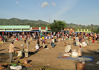
Jinka is a market town in southern Ethiopia. Located in the hills north of the Tama Plains, this town is the capital of the Debub Omo Zone of the Southern Nations, Nationalities, and Peoples Region. Currently Jinka is the center of Jinka town administration. Jinka has a latitude and longitude of 5°47′N36°34′E and an elevation of 1490 meters above sea level. It is one of the most famous tourist destinations in the country. It is also an important center for at least sixteen indigenous ethnic groups as well as others from the rest of the country.

South Omo Zone is a zone in the Ethiopian Southern Nations, Nationalities and Peoples' Region (SNNPR). Debub Omo is bordered on the south by Kenya, on the southwest by the South Sudan, on the west by Bench Maji, on the northwest by Keffa, on the north by Konta, Gamo Gofa and Basketo, on the northeast by Dirashe and Konso, and on the east by the Oromia Region. The administrative center of Debub Omo is Jinka.

North Omo Zone was a zone in the Southern Nations, Nationalities, and Peoples' Region of Ethiopia. It was named after the Omo River, which flows in the western area of the former zone. In 2000 it was split into three zones: Dawro, Gamo Gofa, and Wolayita; and Basketo and Konta became special woredas.
Dirashe is one of the woredas in the Southern Nations, Nationalities, and Peoples' Region (SNNPR) of Ethiopia. Prior to 2011, Dirashe was not part of any Zone in the SNNPR and was therefore considered a Special woreda, an administrative subdivision which is similar to an autonomous area. In 2011, the Segen Area Peoples Zone was established, which includes Dirashe woreda and the 3 former special woredas surrounding it. It is named for the Dirashe people, whose homelands lie in the eastern part of this woreda.
Kuraz is one of the woredas in the Southern Nations, Nationalities, and Peoples' Region of Ethiopia. It is the homeland of Daasanach people. Part of the Debub Omo Zone, Kuraz is bordered on the south by Kenya, on the west by the Ilemi Triangle, on the north by Nyangatom, and on the east by Hamer. The Omo River is flowing through Kuraz to Lake Turkana at the border of Kenya. The administrative center of this woreda is Omorate. Nyangatom woreda was separated from Kuraz.
Konta, previously called Ela, is a woreda in the South West Region of Ethiopia. It is named after Konta people who speak the dialects called Kontatsuwa, Omotic languages. Because Konta is not part of any zone in the SNNPR, it is considered a special woreda, an administrative subdivision which is similar to an autonomous area. This special woreda is bordered on the south by the Omo River which separates it from the Gamo Gofa Zone and Selamgto woreda, Debub Omo Zone, on the west by the Keffa Zone, on the north by the Gojeb River which separates it from the Oromia Region, and on the east by the Dawro Zone; the Denchya River defines the southern part of the boundary with the Keficho Shekicho Zone. The administrative center is Ameya; other towns include Chida.
Basketo is a woreda in the Southern Nations, Nationalities, and Peoples' Region of Ethiopia, named after its inhabitants, the Basketo people. Because Basketo is not part of any administrative Zone in the SNNPR, it is considered a special woreda—an administrative subdivision which is similar to an autonomous area.
Gofa Zone was one of the 17 Zones in the Southern Nations, Nationalities, and Peoples' Region of Ethiopia. Part of the Southern Nations, Nationalities, and Peoples' Region, Gofa Zone was bordered on the south by Kamba and Daramalo woredas, on the southwest by the Debub (South) Omo Zone, on the west by the Basketo special woreda, on the northwest by Dawro Zone, on the north by the Dawro Zone, and on the east by Kucha. The administrative center of Gofa Zone is Sawla; other towns included Bulki. Gofa Zone was separated for Demba Gofa Woreda, Geze Gofa Woreda, Zala Woreda, Malo Koza Woreda, Gada Woreda, Uba Debretsehay Woreda, Oyda Woreda and the two town Administrations Sawla town and Bulki town.
Uba debretsehay was one of the 77 woredas in the Southern Nations, Nationalities, and Peoples' Region of Ethiopia. Part of the Gofa Zone, Uba debretsehay was bordered on the south and west by the Debub Omo Zone, on the northwest by Oyda, on the northeast by sawla, on the east by Zala and on the southeast by Kemba. Towns in Uba debretsehay included Beto and Zaba. Uba debretsehay was divided for Uba Debretsehay and Zala woredas in 2001.
Kemba is one of the woredas in the Southern Nations, Nationalities, and Peoples' Region of Ethiopia. Part of the Gamo Gofa Zone, Kemba is bordered on the southwest by the Debub Omo Zone, on the west by Uba Debretsehay, on the northwest by Zala, on the northeast by Deramalo, on the east by Bonke, and on the southeast by the Dirashe special woreda; the Weito River defines the boundary with Bonke and Dirashe. The major town in this woreda is Kemba.
Selamago is a woreda in the Southern Nations, Nationalities, and Peoples' Region of Ethiopia. Part of the Debub Omo Zone, Selamago is bordered on the south by Nyangatom, on the west and north by the Omo River which separates it from the Bench Maji, Keffa and Konta, on the northeast by the Gamo Gofa, on the east by the Basketo and Bako Gazer, and on the southeast by the Usno River which separates it from Bena Tsemay; the Mago River defines part of the boundary with Bako Gazer. The administrative center of Selamago is Hana.
Suri is one of the woredas in West Omo Zone, in the South West Ethiopia Peoples' Region of Ethiopia. It is named for the Surma or Suri people, whose homeland lies largely in this woreda. Suri woreda is bordered on the south and west by South Sudan, on the northwest by the Gambela Region, on the north by Bero, and on the east by Maji. A portion of the Omo National Park extends into the southern part of this woreda.
Meinit was one of the 77 woredas in the Southern Nations, Nationalities, and Peoples' Region of Ethiopia. Part of the Bench Maji Zone, Meinit was bordered on the south by Dizi, on the west by Sheko, on the north by Bench, on the east by the Keficho Shekicho Zone, and on the southeast by the Omo River which separated it from the Debub Omo Zone. Towns in Meinit included Bachuma, Kela Ketema and Jemu. Meinit was separated for Meinit Goldiya and Meinit Shasha woredas.
Melokoza is one of the woredas in the Southern Nations, Nationalities, and Peoples' Region of Ethiopia. Part of the Gamo Gofa Zone, Melokoza is bordered on the south by Basketo special woreda, on the southwest by the Debub (South) Omo Zone, on the northwest by the Konta special woreda, on the north by the Dawro Zone, and on the east by Demba Gofa and Geze Gofa; the Omo River defines its northwestern boundary separating the woreda from Konta and the Dawro Zone. The major town in Melokoza is Leha.
Gaamo Zone is a zone in the Southern Nations, Nationalities, and Peoples' Region of Ethiopia. It is named for whose homelands lie in this Zone and identifacation of strength,respect. Gamo is bordered on the south by the Dirashe special woreda, on the southwest by Debub (South) Omo and the Basketo special woreda, on the northwest by Konta special woreda, on the north by Dawro and Wolayita, on the northeast by the Lake Abaya which separates it from the Oromia Region, and on the southeast by the Amaro special woreda. The administrative center of Gamo is Arba Minch.
Gelila is one of the woredas in the Southern Nations, Nationalities, and Peoples' Region of Ethiopia. It is also called Northern Aari as it is part of the homeland of Aari people. Part of the Debub Omo Zone, Gelila is bordered on the south by Bako Gazer, on the north by the Basketo special woreda, and on the east by the Gamo Gofa Zone. Gelila was separated from Bako Gazer woreda.
Hamer Bena was one of the 77 woredas in the Southern Nations, Nationalities, and Peoples' Region of Ethiopia. Part of the Debub Omo Zone, Hamer Bena was bordered on the south by Kenya, on the southwest by Kuraz, on the northwest by the Usno River which separates it from Selamago, on the north by Bako Gazer, on the northeast by the Konso special woreda, and on the east by the Oromia Region; the Weito River separated it from Konso and the Oromia Region and the Neri River defined part of the boundary with Bako Gazer. Hamer Bena included part of Lake Chew Bahir along its southeastern border. The administrative center was Dimeka; other towns in Hamer Bena included Arbore, Key Afer, and Turmi. Hamer Bena was separated for Hamer and Bena Tsemay woredas.
Bena Tsemay is one of the woredas in the Southern Nations, Nationalities, and Peoples' Region of Ethiopia. It is named after Banna and Tsamai people who are living at this woreda. Part of the Debub Omo Zone, Bena Tsemay is bordered on the south by Hamer, on the west by Selamago, on the north by Bako Gazer and Male, on the northeast by the Dirashe special woreda, on the east by the Konso special woreda, and on the southeast by the Oromia Region; the Weito River separates it from Konso special woreda and Oromia Region. Western part of this woreda is included in the Mago National Park. The administrative center is Key Afer. Bena Tsemay was part of former Hamer Bena woreda.
Maale is one of the woredas in the Southern Nations, Nationalities, and Peoples' Region of Ethiopia. It is named after the Maale people who are living at this woreda. Part of the Debub Omo Zone, Male is bordered on the south by Bena Tsemay, on the west by Bako Gazer, on the north by the Basketo special woreda and Gelila, on the north and east by the Gamo Gofa Zone, and on the southeast by Dirashe special woreda. Male was separated from Bako Gazer woreda.