Ballari (city)

Last updated

Bellary
Ballari
Bellary Fort.JPG
India Karnataka location map.svg
Red pog.svg
Bellary
Location in Karnataka, India
India location map 3.png
Red pog.svg
Bellary
Bellary (India)
Coordinates: 15°06′N76°55′E / 15.100°N 76.917°E / 15.100; 76.917 Coordinates: 15°06′N76°55′E / 15.100°N 76.917°E / 15.100; 76.917
CountryFlag of India.svg  India
State Karnataka
Region Hyderabad-Karnataka, Deccan
District Bellary
Government
  Type Municipal Corporation
  BodyBallari City Corporation
  MayorRajeshwari Subbarayudu [1]
   Deputy Mayor Ms. Malan Bee S [1]
   Commissioner Sri.P.G.Ramesh [2]
Area
   City Corporation 92.78 km2 (35.82 sq mi)
Elevation
485 m (1,591 ft)
Population
 (2011 census) [3]
   City Corporation 410,445
  Rank 111 (India), 7th (Karnataka)
  Density4,400/km2 (11,000/sq mi)
   Metro
477,537
Demonym Ballarians
Languages
  Official Kannada
  Regional Telugu, Urdu
Time zone Indian Standard Time
PIN
583 10x [4]
Telephone code(+91) 8392 [5]
ISO 3166 code IN-KA
Vehicle registration KA-34
Sex ratio 1.04 [3] /
Literacy79% [3]
Website ballaricity.mrc.gov.in

Ballari, officially Bellary, in the eponymous Ballari district, is a city in the state of Karnataka, India.

Contents

History

Core area of Western Chalukya monuments, roughly corresponding to Sindavadi-1000 Western Chalukya Monuments.svg
Core area of Western Chalukya monuments, roughly corresponding to Sindavadi-1000
Madras province (South), 1909 showing Ballari Madras Prov South 1909.jpg
Madras province (South), 1909 showing Ballari

Ballari was a part of Rayalaseema (Ceded Districts) which was part of Madras Presidency till 1 November 1956.

The Ballari city municipal council was upgraded to a city corporation in 2004. [6]

The Union Ministry of Home Affairs of the Government of India approved a proposal [7] to rename the city in October 2014 and Ballari was renamed to "Ballari" on 1 November 2014. [8]

Geography

Ballari Fort BELLARY FORT 6.jpg
Ballari Fort

Ballari is located at 15°09′N76°56′E / 15.15°N 76.93°E / 15.15; 76.93 . The city stands in the midst of a wide, level plain of black cotton soil. [9] Granite rocks and hills form a prominent feature of Ballari. The city is spread mainly around two hills of granite composition, the Ballari Hill and the Kumbara Gudda.

Ballari Hill has a circumference of nearly 2 miles (3.2 km) and a height of 480 feet (150 m). The length of this rock from north-east to south-west is about 1,150 ft (350 m). To the east and south lies an irregular heap of boulders, to the west there is an unbroken monolith, and the north is walled by bare, rugged ridges. [9]

Kumbara Gudda looks like the profile of a human face from the south-east. It is also known as Face Hill. [9]

Climate

Climate data for Bellary (1981–2010, extremes 1901–2012)
MonthJanFebMarAprMayJunJulAugSepOctNovDecYear
Record high °C (°F)37.6
(99.7)
40.5
(104.9)
43.0
(109.4)
45.4
(113.7)
44.6
(112.3)
44.7
(112.5)
39.5
(103.1)
39.0
(102.2)
38.4
(101.1)
39.0
(102.2)
38.4
(101.1)
35.6
(96.1)
44.7
(112.5)
Average high °C (°F)31.4
(88.5)
34.4
(93.9)
38.1
(100.6)
40.4
(104.7)
39.6
(103.3)
35.3
(95.5)
32.7
(90.9)
31.9
(89.4)
32.3
(90.1)
31.8
(89.2)
30.8
(87.4)
30.2
(86.4)
34.1
(93.4)
Average low °C (°F)15.6
(60.1)
18.1
(64.6)
21.1
(70.0)
23.9
(75.0)
24.4
(75.9)
23.3
(73.9)
23.0
(73.4)
22.7
(72.9)
21.9
(71.4)
20.9
(69.6)
18.3
(64.9)
15.6
(60.1)
20.7
(69.3)
Record low °C (°F)7.0
(44.6)
8.5
(47.3)
10.0
(50.0)
13.0
(55.4)
14.5
(58.1)
14.8
(58.6)
15.5
(59.9)
15.0
(59.0)
15.0
(59.0)
12.5
(54.5)
8.4
(47.1)
8.0
(46.4)
7.0
(44.6)
Average rainfall mm (inches)2.9
(0.11)
2.3
(0.09)
6.0
(0.24)
17.2
(0.68)
54.3
(2.14)
59.2
(2.33)
42.6
(1.68)
70.0
(2.76)
111.0
(4.37)
89.0
(3.50)
39.5
(1.56)
5.5
(0.22)
499.5
(19.67)
Average rainy days0.50.20.61.53.43.83.84.75.45.82.40.532.7
Average relative humidity (%) (at 17:30 IST)43373029345056585862565047
Source: India Meteorological Department [10] [11]

Demographics

Ballari Town Bellary Town, Karnataka.jpg
Ballari Town

According to the 2011 Census of India, the urban population of Ballari was 410,445; of whom 206,149 were male and 204,296 female. 280,610 of the population were literate and 52,413 of the population were under 7 years of age. [12] The population in 2001 was recorded as 316,766. [13]

Religions in Bellary City (2011) [14]
ReligionPercent
Hinduism
70.33%
Islam
26.53%
Christianity
1.71%
Jainism
0.79%
Other or not stated
0.65%

Languages

Languages of Bellary City (2011) Census

   Kannada (36.25%)
   Telugu (28.06%)
   Urdu (25.78%)
   Marwari (3.01%)
   Marathi (1.82%)
   Tamil (1.74%)
   Hindi (1.23%)
   Malayalam (1.08%)
  Others (1.03%)

Both Kannada (36.25%) and Telugu (28.06%) are the predominant languages, Kannada is the official language, Urdu (25.78%) is also widely spoken, Whereas, Marwari (3.01%), Marathi (1.82%), Tamil (1.74%), Hindi (1.23%), Malayalam (1.08%) and Others (1.03%) are also spoken in minority. [15]

Economy

Industries

Textiles and garments

  • Cotton processing
With cotton being one of the major agricultural crops around Ballari historically, the city has had a thriving cotton processing industry in the form of ginning, spinning and weaving plants. The earliest steam cotton-spinning mill was established in 1894, which by 1901 had 17,800 spindles, and employed 520 hands. [9]
The city continues to thrive in this sector with one spinning mill and numerous cotton ginning and pressing mills, hand looms and power looms. [16]
  • Garment manufacture
Ballari has a historic garment industry dating back to the First World War period, when the Marathi speaking "Darji" (tailor) community with its native skills in tailoring migrated from the current Maharashtra region to stitch uniforms for the soldiers of the colonial British Indian Army stationed at Ballari. After the war, the community switched to making uniforms for school children, and gradually the uniforms made here became popular all over the country. [17] [18]
Currently, Ballari is well known for its branded and unbranded denim garments, with brands like Point Blank, Walker, Dragonfly and Podium being successfully marketed nationally and internationally. [18] There are about 260 denim garment units in Ballari with nearly 3000 families working in these units. [16]

Notable people

See Category:People from Bellary

Related Research Articles

<span class="mw-page-title-main">Kurnool district</span> District of Andhra Pradesh, India

Kurnool district is one of the eight districts in the Rayalaseema region of the Indian state of Andhra Pradesh. It is located in the North western part of the state and is bounded by Jogulamba Gadwal district of Telangana in the north, Raichur district of Karnataka in the northwest, Bellary district of Karnataka in the west, Anantapur district in the south and Nandyal district in the east. The city of Kurnool is the headquarters of the district. It has a population of 2,271,686 of which 28.35% were urban as of 2011.

<span class="mw-page-title-main">Rayadurgam</span> Town in Andhra Pradesh, India

Rayadurga is a Town in Anantapur District in the Indian state of Andhra Pradesh. It is governed by a municipal council. Rayadurga is known for its production of Textile goods and textile manufacturing industry. Rayadurga is in Southern India about 451.6 km (280.6 mi) from Hyderabad. Rayadurga is now slowly developing with proper transportation, modern amenities. Rayadurgam is well connected with other cities in Andhra Pradesh and Karnataka through well infrastructure of NH 544DD Highway. The nearest airport is Ballari Airport in Karnataka followed by Kurnool, Puttaparthi and Bengaluru. Rayadurga also has a train station with major stations nearby such as Ballari, Guntakal, Gooty & Anantapur.

Siruguppa is a town and headquarters of the Siruguppa taluk and second largest city in Ballari district after Hospete carved out of Ballari district of Indian state of Karnataka.

Tekkalakote, also known as Tekkalkota is a Panchayat town, and Pre-historic Neolithic site in Siruguppa taluk of Ballari district in the Indian state of Karnataka.

Karnataka, with a total population of 61,100,000, is one of the major states in South India. Kannada is the official language of Karnataka. Other linguistic minorities in the state are Tulu, Kodava, Konkani and Urdu. Karnataka is also in the forefront of population control measures with the world's first two birth control clinics being set up in 1930 in the Mandya district.

<span class="mw-page-title-main">G. Janardhana Reddy</span> Indian politician

Gali Janardhana Reddy is an Indian industrialist and politician affiliated with the Kalyana Rajya Pragati Party

Badanahatti is a village in the southern state of Karnataka, India. It is located in the Kurugodu taluk of Ballari district in Karnataka.

Dharmavaram Ramakrishnamacharyulu was a Telugu dramatist and playwright from Bellary. He was known as "Andhra Nataka Pithamaha" and wrote more than 30 original plays.

<span class="mw-page-title-main">Bellary Fort</span>

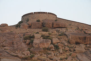
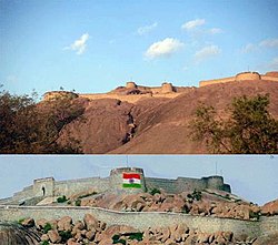
The Bellary Fort was built on top of a hill called the "Ballari Gudda" or the Fort Hill. It is situated in the historic city of Bellary, in the Bellary district, in Karnataka state, India. It was built in two parts namely, the Upper Fort and the Lower Fort. The Upper Fort was built by Hanumappa Nayaka, a feudatory of Vijayanagara Empire, but the Lower Fort was built by Hyder Ali in later part of the 18th century.

Karnataka is a state in the southern part of India. It was created on 1 November 1956, with the passing of the States Reorganisation Act. Karnataka is bordered by the Arabian Sea to the west, Goa to the north-west, Maharashtra to the north, Telangana and Andhra Pradesh to the east, Tamil Nadu to the south-east, and Kerala to the south-west. The state covers an area of 74,122 sq mi (191,976 km2), or 5.83% of the total geographical area of India. It comprises 30 districts. Kannada is the official language of Karnataka and as per the 2011 census is the mother tongue of 66.5% of the population. Various ethnic groups with origins in other parts of India have unique customs and use languages at home other than Kannada, adding to the cultural diversity of the state. Significant linguistic minorities in the state in 2011 included speakers of Urdu (10.8%), Telugu (5.8%), Tamil (3.5%), Marathi (3.4%), Hindi (3.2%), Tulu (2.6%), Konkani (1.3%) and Malayalam (1.3%).

<span class="mw-page-title-main">Bellary Raghava</span> Indian playwright and actor

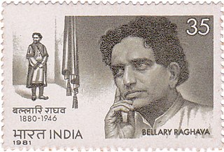
Bellary Raghava was an Indian playwright and actor, known for his works predominantly in Telugu theatre and cinema. His uncle Dharmavaram Ramakrishnamacharyulu was a pioneering dramatist in Telugu, and initiated him on the stage. Raghava was also associated with another dramatist from Bellary, Kolachalam Srinivasa Rao. His students include female artists like Sarojini Kopparapu, Padmavati Kommuri, Annapurna Kakinada, and male artists like Vasudevarao K.S., Apparao Basavaraju and Banda Kanakalingeshwara Rao.

Jodikasinayakanahalli is a village in the southern state of Karnataka, India.

<span class="mw-page-title-main">Kenchanagudda</span> Village in Karnataka, India

Kenchanagudda is a village in the southern state of Karnataka, India. The village is located in the Siruguppa taluk of Ballari district.

<span class="mw-page-title-main">Tekur Subramanyam</span>

Tekur Subramanyam was an Indian Freedom Fighter and politician from Bellary, India. For his involvement in the Independence Movement, he was jailed several times by the British Colonial administration, many times at Bellary's Allipura Jail. Tekur was the first post-independence MP of Bellary, elected thrice in a row since 1952. He was also the Political Secretary to India's first Prime Minister, Jawaharlal Nehru.

Ballari pronounced is a historic city in Bellary district in Karnataka state, India.

<span class="mw-page-title-main">Daroji Sloth Bear Sanctuary</span> Sloth bear sanctuary in India

Daroji Sloth Bear Sanctuary is located in Ballari district in Karnataka. This is Asia's first sloth bear Sanctuary. It is spread over 82.72 km2 (31.94 sq mi). The sanctuary was created exclusively for the conservation of the sloth bear. It is about 50 km from Ballari and about 15 km from the World Heritage Site Hampi. The area between Daroji in Sandur taluka and Ramasagar of Hospet Taluk is host to numerous sloth bears.

<span class="mw-page-title-main">Bellary Assembly constituency</span> Legislative Assembly constituency in Karnataka, India

Bellary Assembly seat is one of the 224 seats in Karnataka State Assembly in India. It is part of Bellary Lok Sabha seat. The constituency is reserved for Scheduled Tribes after delimitation in 2008. It is a stronghold of B Sriramulu. It consists of 11 wards of Bellary City. The areas Cowl Bazar, TB Sanatorium, and Contonment belong to this constituency. It has both urban and rural votes.

<span class="mw-page-title-main">Bellary City Assembly constituency</span> Legislative Assembly constituency in Karnataka, India

Bellary City Assembly seat is one of the seats in Karnataka State Assembly in India. It is part of Bellary Lok Sabha seat. The constituency includes 28 Wards of Ballari Mahanagara Palika. The constituency came into existence after 2008 Delimitation. It was a part of Bellary (AS).

References

Maps

    General

    1. 1 2 "Bellary City Corporators". Archived from the original on 25 June 2011. Retrieved 5 February 2015.
    2. "Bellary City Staff". Archived from the original on 20 May 2006. Retrieved 5 February 2015.
    3. 1 2 3 "District Census Handbook – Guntur" (PDF). Census of India. The Registrar General & Census Commissioner. p. 22. Retrieved 6 November 2016.
    4. "Indiapost PIN Search for 'bellary'". Archived from the original on 4 May 2007. Retrieved 8 May 2007.
    5. "PPP India STD Code Search for 'bellary'". Archived from the original on 4 May 2007. Retrieved 8 May 2007.
    6. "Karnataka. Bellary City Municipal Council upgraded to corporation". The Hindu . 26 September 2004. Archived from the original on 21 December 2016. Retrieved 8 December 2016.
    7. "GOVERNMENT OF INDIA, MINISTRY OF HOME AFFAIRS" (PDF).
    8. New City, Names to Karnatka. "New name for cities". The Hindu. Retrieved 1 November 2014.
    9. 1 2 3 4 5 The Imperial Gazetteer of India, volume 7. Oxford: Clarendon Press. 1908. pp. 158–176.
    10. "Station: Bellary Climatological Table 1981–2010" (PDF). Climatological Normals 1981–2010. India Meteorological Department. January 2015. pp. 119–120. Archived from the original (PDF) on 5 February 2020. Retrieved 18 April 2020.
    11. "Extremes of Temperature & Rainfall for Indian Stations (Up to 2012)" (PDF). India Meteorological Department. December 2016. p. M90. Archived from the original (PDF) on 5 February 2020. Retrieved 18 April 2020.
    12. "Census of India 2011". Census Commission of India. Retrieved 8 December 2016.
    13. "Census of India 2001" (PDF). Census Commission of India. Retrieved 8 December 2016.
    14. "C-1 Population By Religious Community - Karnataka". Census of India.
    15. "Census of India 2001" (PDF). Census Commission of India. Retrieved 8 December 2016.
    16. 1 2 "Karnataka Handloom". Archived from the original on 27 September 2011. Retrieved 23 July 2010.
    17. "Bellary Portal". Archived from the original on 20 July 2002. Retrieved 23 July 2010.
    18. 1 2 "Jeans Industry in Bellary". Archived from the original on 22 December 2008. Retrieved 23 July 2010.
    19. "This jailhouse has a rich past". 26 April 2010. Retrieved 4 June 2010.
    20. "A Congress bastion since 1952". Archived from the original on 26 January 2013. Retrieved 4 June 2010.{{cite web}}: CS1 maint: unfit URL (link)
    21. "Caste will play a vital role in Bellary" . Retrieved 4 June 2010.