Bambra, Victoria

Last updated
Bambra
Victoria
Australia Victoria Surf Coast Shire location map.svg
Red pog.svg
Bambra
Coordinates 38°21′42″S143°57′08″E / 38.36167°S 143.95222°E / -38.36167; 143.95222 Coordinates: 38°21′42″S143°57′08″E / 38.36167°S 143.95222°E / -38.36167; 143.95222
Population101 (2016 census) [1]
Postcode(s) 3241
Location
LGA(s) Surf Coast Shire
State electorate(s) Polwarth
Federal Division(s) Corangamite
Localities around Bambra:
Birregurra Winchelsea South Winchelsea South
Deans Marsh Bambra Wensleydale
Deans Marsh Boonah Wensleydale

Bambra is a rural locality in the Surf Coast Shire, Victoria, Australia. [2] In the 2016 census, Bambra had a population of 101 people. [1] It is named after an Aboriginal word for mushroom. [3]

Suburbs and localities are the names of geographic subdivisions in Australia, used mainly for address purposes. The term locality is used in rural areas, while the term suburb is used in urban areas. Australian postcodes closely align with the boundaries of localities and suburbs.

Surf Coast Shire Local government area in Victoria, Australia

The Surf Coast Shire is a local government area in the Barwon South West region of Victoria, Australia, located in the south-western part of the state. It covers an area of 1,560 square kilometres (600 sq mi) and at the 2016 Census had a population of over 29,000. It includes the towns of Aireys Inlet, Anglesea, Lorne, Moriac, Torquay and Winchelsea. It was formed in 1994 from the amalgamation of the Shire of Winchelsea, Shire of Barrabool and part of the former City of South Barwon, which was, at that point, part of the City of Greater Geelong.

Victoria (Australia) State in Australia

Victoria is a state in south-eastern Australia. Victoria is Australia's smallest mainland state and its second-most populous state overall, thus making it the most densely populated state overall. Most of its population lives concentrated in the area surrounding Port Phillip Bay, which includes the metropolitan area of its state capital and largest city, Melbourne, Australia's second-largest city. Victoria is bordered by Bass Strait and Tasmania to the south, New South Wales to the north, the Tasman Sea to the east, and South Australia to the west.

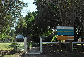
The locality was initially named "Retreat", but was later renamed Bambra after an Aboriginal word for mushroom. The area was opened up for selection in the 1860s. Bambra State School was opened on 20 September 1866, closed temporarily in 1945-1946, and closed permanently in 1969. The Bambra Chapel, a Bible Christian Church, was opened in 1868, and became a Methodist church in 1903. A second church, the Holy Trinity Anglican Church, held its first service on 25 May 1902. Bambra Post Office opened on 23 September 1892 and closed on 29 September 1973. [4] [5] The churches have also closed, although one survives as a private house. [6]

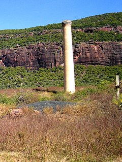
The area has predominantly been used for agricultural, pastoral and dairying purposes; however, a coal mine in adjacent Winchelsea South, sometimes referred to as the Bambra mine, was active from 1921 until between 1928 and 1931, and from 1943 to 1957. [3]

Winchelsea South, Victoria Victoria, Australia

Winchelsea South is a rural locality in the Surf Coast Shire, Victoria, Australia. In the 2016 census, Winchelsea South had a population of 179 people.

The locality still has a public hall, cemetery and a Hare Krishna retreat. [7] [8] [9]

Related Research Articles

Johanna, Victoria Town in Victoria, Australia

Johanna is a small locality on the coast of Victoria, Australia located west of Cape Otway in the Colac Otway Shire. It is named after the schooner Joanna that was wrecked at the mouth of the Johanna River on 22 September 1843.

Baralaba, Queensland Town in Queensland, Australia

Baralaba is a small town and rural locality in the Shire of Banana in central Queensland, Australia. In the 2016 census, Baralaba had a population of 314 people.

Mount Mulligan, Queensland Town in Queensland, Australia

Mount Mulligan is a former mining town and rural locality in Shire of Mareeba, Queensland, Australia. It is the site of the Mount Mulligan mine disaster, Queensland's worst mining disaster.

Balliang, Victoria Town in Victoria, Australia

Balliang is a locality in Victoria, Australia. It is divided between the Shire of Moorabool and City of Greater Geelong local government areas. It lies north of Geelong and 54 kilometres (34 mi) from the state capital, Melbourne. At the 2016 census, Balliang had a population of 290.

Macalister, Queensland Town in Queensland, Australia

Macalister is a town and a locality in the Western Downs Region, Queensland, Australia. At the 2006 census, Macalister and the surrounding area had a population of 486.

Kajabbi Town in Queensland, Australia

Kajabbi is a town in the locality of Three Rivers, Shire of Cloncurry, Queensland, Australia.

Camboon, Queensland Suburb of Shire of Banana, Queensland, Australia

Camboon is a locality in the Shire of Banana, Queensland, Australia.

Modewarre Suburb of Surf Coast Shire, Victoria, Australia

Modewarre is a locality in the Surf Coast Shire, Victoria, Australia. The town adjoins Lake Modewarre. In the 2016 census, Modewarre had a population of 276 people.

Buckley, Victoria Suburb of Surf Coast Shire, Victoria, Australia

Buckley is a rural locality in the Surf Coast Shire, Victoria, Australia. It was formerly known as Laketown. In the 2016 census, Buckley had a population of 211 people.

Mount Moriac, Victoria Suburb of Surf Coast Shire, Victoria, Australia

Mount Moriac is a rural locality in the Surf Coast Shire, Victoria, Australia. In the 2016 census, Mount Moriac had a population of 240 people.

Freshwater Creek, Victoria Town in Victoria, Australia

Freshwater Creek is a small rural community in the Surf Coast Shire, Victoria, Australia. In the 2016 census, Freshwater Creek had a population of 414 people.

Ombersley, Victoria Suburb of Colac Otway Shire, Victoria, Australia

Ombersley is a rural locality in Victoria, Australia. Most of the locality is in Colac Otway Shire, with a portion being in adjacent Surf Coast Shire. In the 2016 census, Ombersley had a population of 97.

Paraparap, Victoria Suburb of Surf Coast Shire, Victoria, Australia

Paraparap is a rural locality in the Surf Coast Shire, Victoria, Australia. In the 2011 census, Paraparap had a population of 151 people.

Pennyroyal, Victoria Suburb of Surf Coast Shire, Victoria, Australia

Pennyroyal is a rural locality in Victoria, Australia. Most of the locality is situated in the Surf Coast Shire; a small section is situated in the Shire of Colac Otway. In the 2016 census, Pennyroyal had a population of 86.

Gnarwarre, Victoria Victoria, Australia

Gnarwarre is a rural locality in the Surf Coast Shire, Victoria, Australia. In the 1800s, the locality was alternately known as Shankhill. In the 2016 census, Gnarwarre had a population of 267 people.

Eastern View, Victoria Town in Victoria, Australia

Eastern View is a small coastal town in the Surf Coast Shire, Victoria, Australia.

Boonah, Victoria Suburb of Surf Coast Shire, Victoria, Australia

Boonah is a rural locality in the Surf Coast Shire, Victoria, Australia.

Benwerrin, Victoria Town in Victoria, Australia

Benwerrin is a rural locality in the Surf Coast Shire, Victoria, Australia.

Barrabool, Victoria Town in Victoria, Australia

Barrabool is a rural locality in the Surf Coast Shire, Victoria, Australia. In the 2016 census, Barrabool had a population of 235 people.

References

  1. 1 2 Australian Bureau of Statistics (27 June 2017). "Bambra (SSC)". 2016 Census QuickStats. Retrieved 17 November 2014. Blue pencil.svg
  2. "Bambra (entry 100245)". VICNAMES. Government of Victoria . Retrieved 17 June 2014.
  3. 1 2 Kellaway, Carlotta. Farmland, Forest & Surf: Environmental History of Surf Coast Shire (PDF). Surf Coast Shire. p. 58.
  4. Blake, L. J. (1973). Vision and Realisation: A Centenary History of State Education in Victoria (Volume 2). Education Department of Victoria. pp. 1050–1051.
  5. Premier Postal History. "Post Office List". Premier Postal Auctions. Retrieved 17 June 2014.
  6. 70 Bambra School Road, Bambra. domain.com.au.
  7. "Bambra Hall". Surf Coast Shire. Retrieved 17 June 2014.
  8. "Bambra Cemetery". australiancemeteries.com. Retrieved 17 June 2014.
  9. "Hare Krishna Valley". Hare Krishna Valley. Retrieved 17 June 2014.