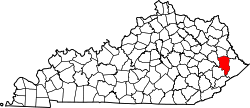
Banner, Kentucky

Last updated
Banner, Kentucky
USA Kentucky location map.svg
Red pog.svg
Banner
Location within the state of Kentucky
Usa edcp location map.svg
Red pog.svg
Banner
Banner (the United States)
Coordinates: 37°35′57″N82°42′5″W / 37.59917°N 82.70139°W / 37.59917; -82.70139 Coordinates: 37°35′57″N82°42′5″W / 37.59917°N 82.70139°W / 37.59917; -82.70139
Country United States
State Kentucky
County Floyd
Elevation
659 ft (201 m)
Time zone UTC-5 (Eastern (EST))
  Summer (DST) UTC-4 (EST)
ZIP codes
41603
GNIS feature ID507449 [1]

Banner is an unincorporated community in Floyd County, Kentucky, United States. It was also known as Mouth of Prater.

History

A post office has been in operation at Banner since 1897. [2] The community was named in honor of David Banner, a local settler. [3]

Related Research Articles

Floyd County, Kentucky U.S. county in Kentucky

Floyd County is a county located in the U.S. state of Kentucky. As of the 2010 census, the population was 39,451. Its county seat is Prestonsburg. The county, founded in 1800, is named for Colonel John Floyd (1750–1783).

Floyd County, Indiana U.S. county in Indiana

Floyd County is a county located in the U.S. state of Indiana. As of 2018, the population was 77,781. The county seat is New Albany. Floyd County has the second-smallest land area in the entire state. It was formed in the year 1819 from neighboring Clark, and Harrison counties.

Prestonsburg, Kentucky City in Kentucky, United States

Prestonsburg is a small home rule-class city in and the county seat of Floyd County, Kentucky, United States. It is in the eastern part of the state in the valley of the Big Sandy River. The population was 3,255 at the time of the 2010 census, down from 3,612 at the 2000 census.

Allen, Kentucky City in Kentucky, United States

Allen is a home rule-class city in Floyd County, Kentucky, in the United States. The population was 193 at the 2010 census, up from 150 at the 2000 census.

Martin, Kentucky City in Kentucky, United States

Martin is a home rule-class city in Floyd County, Kentucky, in the United States. The population was 634 as of the 2010 census.

Floyds Knobs, Indiana Unincorporated community in Indiana, United States

Floyds Knobs is a small unincorporated community in Lafayette Township, Floyd County, Indiana, United States. Historically a farming community on the outskirts of New Albany, it has since become a bedroom community for Louisville, Kentucky. It contains subdivisions, farms, small shopping centers, churches, and transmitters for many of the area's television and radio stations. It is also the location of Floyd Central High School.

East Point, Kentucky Unincorporated community in Kentucky, United States

East Point is an unincorporated community in Johnson County, Kentucky, United States. The community's first settlers were the Matthias Harman, Greer and Auxier families at Blockhouse Bottom. Their fort, Fort Harmon, was the site of numerous Indian raids. The first post office was originally established in Floyd County on February 6, 1871, but was moved to Johnson County in 1877. Its current ZIP code is 41216.

Auxier, Kentucky Census-designated place in Kentucky, United States

Auxier is an unincorporated community and census-designated place (CDP) in Floyd County, Kentucky, United States. The 2010 United States Census reported that Auxier's population was 669, of which 661 persons were white and 2 persons were black.

Tram, Kentucky Unincorporated community in Kentucky, United States

Tram is an unincorporated community in Floyd County, Kentucky, United States.

Hi Hat, Kentucky Unincorporated community in Kentucky, United States

Hi Hat is an unincorporated community and coal town located in Floyd County, Kentucky, United States. Their post office is still open.

Harold, Kentucky Unincorporated community in Kentucky, United States

Harold is an unincorporated community located in Floyd County, Kentucky, United States.

Grethel, Kentucky Unincorporated community in Kentucky, United States

Grethel is an unincorporated community located in Floyd County, Kentucky, United States.

Little Floyd County, Kentucky Unincorporated community in Kentucky, United States

Little Floyd County is an unincorporated community in Pike County, Kentucky, United States. Little Floyd County is located on Mare Creek 7.3 miles (11.7 km) northwest of Pikeville.

Watergap, Kentucky Unincorporated community in Kentucky, United States

Watergap is an unincorporated community and coal town in Floyd County, Kentucky, United States.

Ivel, Kentucky Unincorporated community in Kentucky, United States

Ivel is an unincorporated community and coal town in Floyd County, Kentucky, United States.

Emma, Kentucky Unincorporated community in Kentucky, United States

Emma is an unincorporated community and coal town in Floyd County, Kentucky, United States.

Garrett, Floyd County, Kentucky Unincorporated community in Kentucky, United States

Garrett is an unincorporated community and coal town in Floyd County, Kentucky, United States.

Eastern, Kentucky Unincorporated community in Kentucky, United States

Eastern is an unincorporated community located in Floyd County, Kentucky, United States.

Banner Fork Coal Company, Kentucky Unincorporated community in Kentucky, United States

Banner Fork Coal Company was an unincorporated community and coal town in Harlan County, Kentucky, United States.

Risner is an unincorporated community in Floyd County, in the U.S. state of Kentucky.

References

  1. U.S. Geological Survey Geographic Names Information System: Banner, Kentucky
  2. "Floyd County". Jim Forte Postal History. Archived from the original on 25 December 2015. Retrieved 16 April 2015.
  3. Rennick, Robert M. (28 August 2013). Kentucky Place Names. University Press of Kentucky. p. 55. ISBN   0-8131-4401-9.