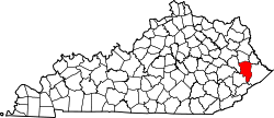
Blue River, Kentucky

Last updated

Blue River, Kentucky
USA Kentucky location map.svg
Red pog.svg
Blue River
Location within the state of Kentucky
Usa edcp location map.svg
Red pog.svg
Blue River
Blue River (the United States)
Coordinates: 37°37′9″N82°50′38″W / 37.61917°N 82.84389°W / 37.61917; -82.84389
Country United States
State Kentucky
County Floyd
Elevation
666 ft (203 m)
Time zone UTC-5 (Eastern (EST))
  Summer (DST) UTC-4 (EST)
ZIP codes
41607
GNIS feature ID507534 [1]

Blue River is an unincorporated community in Floyd County, Kentucky, United States.

Related Research Articles

<span class="mw-page-title-main">Kentucky</span> U.S. state

Kentucky, officially the Commonwealth of Kentucky, is a state in the Southeastern region of the United States and one of the states of the Upper South. Kentucky borders Illinois, Indiana, and Ohio to the north, West Virginia to the northeast, Virginia to the east, Tennessee to the south, and Missouri to the west. Its northern border is defined by the Ohio River. Its capital is Frankfort and its largest city is Louisville. Its population was approximately 4.5 million in 2020.

<span class="mw-page-title-main">Frankfort, Kentucky</span> Capital city of Kentucky, United States

Frankfort is the capital city of the U.S. state of Kentucky and the seat of Franklin County. It is a home rule-class city. The population was 28,602 at the 2020 United States census. Located along the Kentucky River, Frankfort is the principal city of the Frankfort, Kentucky Micropolitan Statistical Area, which includes all of Franklin and Anderson counties. It is the fourth smallest state capital city in the United States by population.

<span class="mw-page-title-main">Daniel Boone</span> American pioneer and frontiersman (1734–1820)

Daniel Boone was an American pioneer and frontiersman whose exploits made him one of the first folk heroes of the United States. He became famous for his exploration and settlement of Kentucky, which was then beyond the western borders of the Thirteen Colonies. In 1775, Boone blazed the Wilderness Road through the Cumberland Gap and into Kentucky, in the face of resistance from American Indians, for whom the area was a traditional hunting ground. He founded Boonesborough, one of the first English-speaking settlements west of the Appalachian Mountains. By the end of the 18th century, more than 200,000 people had entered Kentucky by following the route marked by Boone.

<span class="mw-page-title-main">Perry County, Kentucky</span> County in Kentucky, United States

Perry County is a county in the U.S. state of Kentucky. As of the 2020 census, the population was 28,473. Its county seat is Hazard. The county was founded in 1820. Both the county and county seat are named for Commodore Oliver Hazard Perry, a naval hero in the War of 1812.

<span class="mw-page-title-main">Gallatin County, Kentucky</span> County in Kentucky, United States

Gallatin County, is a county located in the northern part of the U.S. state of Kentucky. Its county seat is Warsaw. The county was founded in 1798 and named for Albert Gallatin, the Secretary of the Treasury under President Thomas Jefferson. Gallatin County is included in the Cincinnati-Middletown, OH-KY-IN Metropolitan Statistical Area. It is located along the Ohio River across from Indiana.

<span class="mw-page-title-main">Scouting in Kentucky</span>

Scouting in Kentucky has a long history, from the 1910s to the present day, serving thousands of youth in programs that suit the environment in which they live. Kentucky has a very early Scouting heritage, as the home state of Daniel Carter Beard.

<span class="mw-page-title-main">Northern Kentucky</span> Geographical region

Northern Kentucky is the third-largest metropolitan area in the United States Commonwealth of Kentucky after Louisville and Lexington, and its cities and towns serve as the de facto "south side" communities of Cincinnati, Ohio. The three main counties of this metro area are Boone, Kenton, and Campbell along the Ohio River, with other counties also included. The label "Northern Kentucky" is used to demonstrate the common identity shared across county and city lines by the residents of these northern counties. Arguably, the label seeks to reverse the divisions that occurred to Campbell County, which, in 1794, included the land of Boone, Kenton, Pendleton Counties, and most of Bracken and Grant Counties. The urban and suburban areas of the northern counties are densely populated. Indeed, of Greater Cincinnati's over two million residents, 450,994 of them live in Northern Kentucky (2019), with the three most northern counties contributing 394,163 residents themselves. The largest cities in each of the three most northern counties are Covington, Florence, and Fort Thomas.

<span class="mw-page-title-main">Jackson Purchase</span> Region in Kentucky

The Jackson Purchase, also known as the Purchase Region or simply the Purchase, is a region in the U.S. state of Kentucky bounded by the Mississippi River to the west, the Ohio River to the north, and the Tennessee River to the east.

<span class="mw-page-title-main">Shawnee</span> Indigenous peoples of the Northeastern Woodlands

The Shawnee are an Indigenous people of the Northeastern Woodlands. Their language, Shawnee is an Algonquian language.

<span class="mw-page-title-main">Ridge-and-Valley Appalachians</span> Physiographic province of the larger Appalachian division

The Ridge-and-Valley Appalachians, also called the Ridge and Valley Province or the Valley and Ridge Appalachians, are a physiographic province of the larger Appalachian division and are also a belt within the Appalachian Mountains extending from southeastern New York in the north through northwestern New Jersey, westward into Pennsylvania through the Lehigh Valley, and southward into Maryland, West Virginia, Virginia, Kentucky, Tennessee, Georgia, and Alabama. They form a broad arc between the Blue Ridge Mountains and the Appalachian Plateau physiographic province. They are characterized by long, even ridges, with long, continuous valleys in between.

<span class="mw-page-title-main">Battle of Blue Licks</span> Battle in the American Revolutionary War

The Battle of Blue Licks, fought on August 19, 1782, was one of the last battles of the American Revolutionary War. The battle occurred ten months after Lord Cornwallis's surrender at Yorktown, which had effectively ended the war in the east. On a hill next to the Licking River in what is now Robertson County, Kentucky, a force of about 50 Loyalists along with 300 indigenous warriors ambushed and routed 182 Kentucky militiamen, who were partially led by Daniel Boone. It was the last victory for the Loyalists and natives during the frontier war. British, Loyalist and Native forces would engage in fighting with American forces once more the following month in Wheeling, West Virginia, during the Siege of Fort Henry.

<span class="mw-page-title-main">Big South Fork National River and Recreation Area</span> Protected area in central northeast Tennessee and southeastern Kentucky, United States

The Big South Fork National River and Recreation Area, commonly known as Big South Fork, preserves the Big South Fork of the Cumberland River and its tributaries in northeastern Tennessee and southeastern Kentucky.

<span class="mw-page-title-main">Ultimate Indoor Football League</span>

The Ultimate Indoor Football League (UIFL) was a regional professional indoor football league that began its inaugural season on February 18, 2011 as the Ultimate Indoor Football League before playing as the United Indoor Football League in 2012, then switched back to "Ultimate" for the 2013 season. After the 2014 season, the league merged with X-League Indoor Football.

<span class="mw-page-title-main">Licking River (Kentucky)</span> River

The Licking River is a partly navigable, 303-mile-long (488 km) tributary of the Ohio River in northeastern Kentucky. The river and its tributaries drain much of the region of northeastern Kentucky between the watersheds of the Kentucky River to the west and the Big Sandy River to the east. The North Fork Licking River, in Pendleton County, Kentucky, is one of its tributaries. The South Fork Licking River, in counties including Harrison County, Kentucky, is another.

<span class="mw-page-title-main">Blue Licks Battlefield State Resort Park</span> State park in Kentucky, United States

Blue Licks Battlefield State Resort Park is a park located near Mount Olivet, Kentucky in Robertson and Nicholas counties. The park encompasses 148 acres (60 ha) and features a monument commemorating the August 19, 1782 Battle of Blue Licks. The battle was regarded as the final battle of the American Revolutionary War.

<span class="mw-page-title-main">Blue Heron, Kentucky</span> Coal town in Kentucky, United States

Blue Heron, also known as Mine 18, is a former coal mining community or coal town on the banks of the Big South Fork of the Cumberland River in McCreary County, Kentucky, United States, that has been recreated and is maintained as an interpretive history area in the Big South Fork National River and Recreation Area.

Transportation in Kentucky includes roads, airports, waterways and rail.

<span class="mw-page-title-main">Outline of Kentucky</span> Overview of and topical guide to Kentucky

The following outline is provided as an overview of and topical guide to the United States Commonwealth of Kentucky:

<span class="mw-page-title-main">Northern Kentucky River Monsters</span> Professional indoor football team based in Highland Heights, Kentucky

The Northern Kentucky River Monsters were a professional indoor football team based in Highland Heights, Kentucky. The River Monsters began play as a charter member of the Ultimate Indoor Football League (UIFL) for its inaugural 2011 season spending one season in the UIFL before reaching an agreement with league management to leave. After a two-year hiatus, the River Monsters returned in 2014 as a member of the South Division of the Continental Indoor Football League (CIFL). The River Monsters played their home games at The Bank of Kentucky Center. On June 6, 2011, it was announced that the UIFL and the River Monsters mutually agreed to part ways, leaving the team free to join another league. However, the UIFL had a lease agreement with the arena, which hampered the likelihood the River Monsters would play in Highland Heights in 2012. The team had been mentioned as a charter member Stadius Football Association in 2012, but that league never got off the ground. The team suspended operations on October 1, 2014.

References