McDowell, Kentucky

Last updated

McDowell, Kentucky
USA Kentucky location map.svg
Red pog.svg
McDowell
Location in Kentucky
Coordinates: 37°27′32″N82°44′03″W / 37.45889°N 82.73417°W / 37.45889; -82.73417
Country Flag of the United States.svg  United States
State Flag of Kentucky.svg  Kentucky
County Floyd
Area
[1]
  Total2.48 sq mi (6.42 km2)
  Land2.48 sq mi (6.41 km2)
  Water0.00 sq mi (0.00 km2)
Elevation
[2]
824 ft (251 m)
Population
 (2020)
  Total661
  Density266.86/sq mi (103.05/km2)
Time zone UTC-5 (Eastern (EST))
  Summer (DST) UTC-4 (EDT)
ZIP code
41647
FIPS code 21-48954
GNIS feature ID2629652 [2]

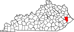
McDowell is an unincorporated community and census-designated place (CDP) in Floyd County, Kentucky, United States. [2]

Contents

Demographics

Historical population
CensusPop.Note
2020 661
U.S. Decennial Census [3]

See also

Related Research Articles

<span class="mw-page-title-main">McDowell County, West Virginia</span> County in West Virginia, United States

McDowell County is a county in the U.S. state of West Virginia. As of the 2020 census, the population was 19,111. Its county seat is Welch. McDowell County is the southernmost county in the state. It was created in 1858 by the Virginia General Assembly and named for Virginia Governor James McDowell. It became a part of West Virginia in 1863, when several Union-affiliated counties seceded from the state of Virginia during the American Civil War. McDowell County is located in the Cumberland Mountains, part of the Appalachia region.

<span class="mw-page-title-main">McDowell County, North Carolina</span> County in North Carolina, United States

McDowell County is a county located in the U.S. state of North Carolina. As of the 2020 census, the population was 44,578. Its county seat is Marion.

<span class="mw-page-title-main">Floyd County, Kentucky</span> County in Kentucky, United States

Floyd County is a county located in the U.S. state of Kentucky. As of the 2020 census, the population was 35,942. Its county seat is Prestonsburg. The county, founded in 1800, is named for Colonel John Floyd (1750–1783).

<span class="mw-page-title-main">Rio Verde, Arizona</span> CDP in Maricopa County, Arizona

Rio Verde is a master-planned community just east of Scottsdale, in Arizona. It is also a census-designated place (CDP) in Maricopa County, Arizona, United States. The population was 2,210 as of the 2020 census, up from 1,811 at the 2010 census.

<span class="mw-page-title-main">Danville, Kentucky</span> City in Kentucky, United States

Danville is a home rule-class city in Boyle County, Kentucky, United States. It is the seat of its county. The population was 17,236 at the 2020 Census. Danville is the principal city of the Danville Micropolitan Statistical Area, which includes all of the Boyle and Lincoln counties. In 2001, Danville received a Great American Main Street Award from the National Trust for Historic Preservation. In 2011, Money magazine placed Danville as the fourth-best place to retire in the United States. Centre College in Danville was selected to host U.S. vice-presidential debates in 2000 and 2012.

<span class="mw-page-title-main">Flatwoods, Kentucky</span> City in Kentucky, United States

Flatwoods is a home rule-class city in Greenup County, Kentucky, United States. The population was 7,325 at the 2020 census, making it the largest city in Greenup County. Flatwoods is a part of the Huntington–Ashland metropolitan area. Locally, Flatwoods is considered to be a bedroom community, as it has no large employer within the city. Many residents work for CSX Transportation, Marathon Petroleum, or King's Daughters Medical Center.

A census-designated place (CDP) is a concentration of population defined by the United States Census Bureau for statistical purposes only.

<span class="mw-page-title-main">Big Sandy, West Virginia</span> Census-designated place in West Virginia, United States

Big Sandy is a census-designated place (CDP) located in McDowell County, West Virginia, United States. As of the 2010 census, its population is 168. The town's name comes from the Big Sandy River, a major tributary of the Ohio River which forms the boundary between West Virginia and Kentucky.

<span class="mw-page-title-main">Cucumber, West Virginia</span> Census-designated place in West Virginia, United States

Cucumber is a census-designated place (CDP) in McDowell County, West Virginia, United States. Its population was 74 at the 2020 census. The community is centered on mining. Named either for nearby Cucumber Creek or for the cucumber trees in the area, it is the only community in the United States with this name. Its post office was still active as of October 2011.

Berwind is a town on the Dry Fork in McDowell County, West Virginia, United States. As of the 2010 census, its population is 278. The town is named for Edward Julius Berwind, owner of the Berwind Company, and was originally a company town. It was later incorporated in 1905. Berwind is the hometown of Vern Bickford, a starting pitcher in Major League Baseball who played with the Braves in Boston (1948-1952) and Milwaukee (1953), and for the Baltimore Orioles (1954). Berwind is also encompassed by the Berwind census designated place.

Crumpler is a census-designated place (CDP) located in McDowell County, West Virginia, United States. As of the 2010 census, its population was 204.

Pageton is a census-designated place (CDP) in McDowell County, West Virginia, United States. As of the 2010 census, its population was 187. Pageton is located on the Tug Fork Branch of the Norfolk and Western Railway, along the Pocahontas seam of rich bituminous coal. Pageton is located on State Route 161 between Thorpe and Anawalt.

The Paducah, KY-IL Micropolitan Statistical Area, as defined by the United States Census Bureau, is an area consisting of five counties – three in the Jackson Purchase region of Kentucky, a fourth Kentucky county bordering the Purchase, and one in southern Illinois – anchored by the city of Paducah, Kentucky.

Maybeury is a census-designated place (CDP) in McDowell County, West Virginia, United States, located on U.S. Route 52 between Northfork and Bramwell. As of the 2010 census, its population was 234.

Raysal is a census-designated place (CDP) in McDowell County, West Virginia, United States. Raysal is located along West Virginia Route 83, 1 mile (1.6 km) southeast of Bradshaw. Raysal has a post office with ZIP code 24879. As of the 2010 census, its population was 465.

<span class="mw-page-title-main">Roderfield, West Virginia</span> Census-designated place in West Virginia, United States

Roderfield is a census-designated place (CDP) in McDowell County, West Virginia, United States. Roderfield is 7 miles (11 km) west-northwest of Welch. Roderfield has a post office with ZIP code 24881. As of the 2010 census, its population is 188.

Vivian is a census-designated place (CDP) in McDowell County, West Virginia, United States. Vivian is located along U.S. Route 52, 1 mile (1.6 km) southeast of Kimball. As of the 2010 census, its population was 82.

<span class="mw-page-title-main">McCarr, Kentucky</span> Unincorporated community in Kentucky, United States

McCarr is an unincorporated community and census-designated places in Pike County, Kentucky, United States.

References

  1. "2020 U.S. Gazetteer Files". United States Census Bureau. Retrieved March 18, 2022.
  2. 1 2 3 U.S. Geological Survey Geographic Names Information System: McDowell, Kentucky
  3. "Census of Population and Housing". Census.gov. Retrieved June 4, 2016.

Commons-logo.svg Media related to McDowell, Kentucky at Wikimedia Commons