Dwale, Kentucky

Last updated

Dwale, Kentucky
USA Kentucky location map.svg
Red pog.svg
Dwale
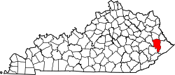
Location in Kentucky
Coordinates: 37°37′15″N82°43′38″W / 37.62083°N 82.72722°W / 37.62083; -82.72722
Country Flag of the United States.svg  United States
State Flag of Kentucky.svg  Kentucky
County Floyd
Area
[1]
  Total0.63 sq mi (1.63 km2)
  Land0.61 sq mi (1.58 km2)
  Water0.02 sq mi (0.06 km2)
Elevation
[2]
758 ft (231 m)
Population
 (2020)
  Total239
  Density392.45/sq mi (151.43/km2)
Time zone UTC-5 (Eastern (EST))
  Summer (DST) UTC-4 (EDT)
ZIP code
41621 [3]
Area code 606
FIPS code 21-23104
GNIS feature ID2629606 [2]

Dwale is an unincorporated community and census-designated place in Floyd County, Kentucky, United States. [4] The 2010 United States Census reported that Dwale's population was 329, of which 312 persons were white and 9 persons were Asian. [5]

Contents

The origins of the name Dwale are unclear. Although it is said to have been named after a town in Wales, no such Welsh place name has been found. [6]

Geography

Dwale is located in north-central Floyd County on the west side of the Levisa Fork, just north of Allen. U.S. Route 23 passes through Dwale, leading northwest 5 miles (8 km) to Prestonsburg, the county seat, and southeast 22 miles (35 km) to Pikeville.

According to the U.S. Census Bureau, the Dwale CDP has a total area of 0.67 square miles (1.74 km2), of which 0.66 square miles (1.70 km2) is land and 0.02 square miles (0.04 km2), or 2.57%, is water. [7]

Demographics

Historical population
CensusPop.Note
2020 239
U.S. Decennial Census [8]

Related Research Articles

<span class="mw-page-title-main">Almanor, California</span> Census-designated place in California, United States

Almanor was a census-designated place (CDP) in Plumas County, California, United States. The population was 0 at the 2010 Census, but as of 2020, the population was reported as 3. Almanor is located 7 miles (11.3 km) south-southeast of Chester.

<span class="mw-page-title-main">Brooks, Kentucky</span> Census-designated place in Kentucky, United States

Brooks is a census-designated place (CDP) in Bullitt County, Kentucky, United States. The population was 2,469 as of the 2020 census, stagnant from 2,401 in the 2010 census. Brooks was struck by a tornado in 1996.

<span class="mw-page-title-main">Wayland, Kentucky</span> City in Floyd County, Kentucky, United States

Wayland is a home rule-class city in Floyd County, Kentucky, United States. The population was 426 at the 2010 census, up from 298 at the 2000 census.

<span class="mw-page-title-main">Phelps, Kentucky</span> CDP in Kentucky, United States

Phelps is a census-designated place (CDP) in Pike County, Kentucky, United States. The population was 1,053 at the 2000 census. It is the easternmost census-designated community in Kentucky.

<span class="mw-page-title-main">Beechwood Trails, Ohio</span> Census-designated place in Ohio, United States

Beechwood Trails is a census-designated place (CDP) in Harrison Township, Licking County, Ohio, United States. The population was 3,276 at the 2020 census.

<span class="mw-page-title-main">Keokee, Virginia</span> Census-designated place in Virginia, United States

Keokee is an unincorporated community and census-designated place (CDP) in Lee County, Virginia, United States. The population was 416 at the 2010 census.

<span class="mw-page-title-main">Lake Marcel-Stillwater, Washington</span> Census-designated place in Washington, United States

Lake Marcel-Stillwater is a census-designated place (CDP) in King County, Washington, United States. The population was 1,277 at the 2010 census.

<span class="mw-page-title-main">Switzer, West Virginia</span> Census-designated place in West Virginia, United States

Switzer is an unincorporated community and census-designated place (CDP) in Logan County, West Virginia, United States. The CDP includes the neighboring unincorporated community of Micco. The total CDP population was 595 at the 2010 census.

Farmersville is a rural Mennonite settlement and a census-designated place (CDP) in West Earl Township, Lancaster County, Pennsylvania, United States. As of the 2010 census the population was 991.

Penryn is an unincorporated community and census-designated place (CDP) in Penn Township, Lancaster County, Pennsylvania, United States. As of the 2010 census the population was 1,024.

<span class="mw-page-title-main">Symsonia, Kentucky</span> Census-designated place in Kentucky, United States

Symsonia is an unincorporated community and census-designated place (CDP) in Graves County, Kentucky, United States. The community lies in the far northeastern part of the county, 13 miles (21 km) southeast of Paducah, 11 miles (18 km) northwest of Benton, and 15 miles (24 km) northeast of the county seat Mayfield, in the Jackson Purchase region of the state. As of the 2010 census, the population of Symsonia was 615.

Ezel is an unincorporated community and census-designated place (CDP) in Morgan County, Kentucky, United States. As of the 2020 census, it had a population of 209. It has a small post office, with the ZIP code 41425.

Kent is an unincorporated community and census-designated place (CDP) in Republican Township, Jefferson County, Indiana, United States. As of the 2010 census it had a population of 70.

<span class="mw-page-title-main">Betsy Layne, Kentucky</span> Census-designated place in Kentucky, United States

Betsy Layne is a census-designated place (CDP) and coal town in Floyd County, Kentucky, United States. It was established in 1875 along the Levisa Fork. The post office opened on May 1, 1908, with Clayton S. Hitchins as postmaster. Its ZIP code is 41605. The 2010 census reported the population to be 688. Stage actress Bette Henritze was a native of Betsy Layne.

Auxier is an unincorporated community and census-designated place (CDP) in Floyd County, Kentucky, United States. The 2010 United States Census reported that Auxier's population was 669, of which 661 persons were white and 2 persons were black.

Maytown is an unincorporated community and census-designated place in Floyd County, Kentucky, United States.

Cleaton is an unincorporated community and census-designated place in Muhlenberg County, Kentucky, United States. As of the 2020 census, it had a population of 168.

Dunmor is an unincorporated community and census-designated place (CDP) in Muhlenberg and Logan counties, Kentucky, United States. As of the 2020 census it had a population of 322.

Flat Lick is an unincorporated community and census-designated place (CDP) in Knox County, Kentucky, United States. As of the 2010 census, the population was 960.

Doe Valley is an unincorporated community and census-designated place (CDP) in Meade County, Kentucky, United States. Its population was 2,270 as of the 2020 census.

References

  1. "2020 U.S. Gazetteer Files". United States Census Bureau. Retrieved March 18, 2022.
  2. 1 2 U.S. Geological Survey Geographic Names Information System: Dwale, Kentucky
  3. "Dwale KY ZIP Code". zipdatamaps.com. 2023. Retrieved June 16, 2023.
  4. "Feature Detail Report for: Dwale, Kentucky." USGS. U.S. Geological Survey Geographic Names Information System: Dwale, Kentucky Retrieved May 12, 2011.
  5. United States Census 2010 US Census report for Kentucky
  6. Rennick, Robert M. (1987). Kentucky Place Names. University Press of Kentucky. p. 87. ISBN   0813126312 . Retrieved April 28, 2013.
  7. "Geographic Identifiers: 2010 Census Summary File 1 (G001), Dwale CDP, Kentucky". American FactFinder. U.S. Census Bureau. Archived from the original on February 13, 2020. Retrieved May 23, 2016.
  8. "Census of Population and Housing". Census.gov. Retrieved June 4, 2016.