
Floyd County is a county located in the U.S. state of Kentucky. As of the 2020 census, the population was 35,942. Its county seat is Prestonsburg. The county, founded in 1800, is named for Colonel John Floyd (1750–1783).
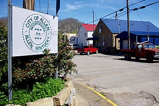
Allen, also known as Allen City, is a home rule-class city in Floyd County, Kentucky, in the United States. The population was 193 at the 2010 census, up from 150 at the 2000 census.

Martin is a home rule-class city in Floyd County, Kentucky, in the United States. The population was 634 as of the 2010 census.

Wayland is a home rule-class city in Floyd County, Kentucky, United States. The population was 426 at the 2010 census, up from 298 at the 2000 census.

North Corbin is a census-designated place (CDP) in Laurel and Knox counties in the U.S. state of Kentucky. The population was 1,727 at the 2020 census down from 1,773 at the 2010 census. The census bureau also lists the Laurel County portion of North Corbin as a CCD with a population of 10,729.

Oneida is an unincorporated community and census-designated place (CDP) in Clay County, Kentucky, United States. Its population was 238 at the 2020 census. It is the home of Oneida Baptist Institute. Goose Creek, the Red Bird River, and Bullskin Creek confluence to form the South Fork of the Kentucky River a few hundred yards from the center of the town.
Bryantsville is an unincorporated community in Garrard County, Kentucky, United States. It lies along U.S. Route 27 northwest of the city of Lancaster, the county seat of Garrard County. Its elevation is 942 feet (287 m). It has a post office with the ZIP code 40410.
Drift, Kentucky is an unincorporated community and coal town in Floyd County, Kentucky, United States. As of the census of 2000, there were 569 people living in the ZIP Code Tabulation Area (ZCTA) for Drift's ZIP code (41619).
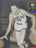
Grady A. Wallace was an All-American basketball player for the South Carolina Gamecocks in 1955–56 and 1956–57. As a senior in 1957, Wallace led the National Collegiate Athletic Association (NCAA) in scoring with 31.3 points per game (ppg), which edged out future Naismith Basketball Hall of Famers Elgin Baylor (29.7) and Wilt Chamberlain (29.6).
Betsy Layne is a census-designated place (CDP) and coal town in Floyd County, Kentucky, United States. It was established in 1875 along the Levisa Fork. The post office opened on May 1, 1908, with Clayton S. Hitchins as postmaster. Its ZIP code is 41605. The 2010 census reported the population to be 688. Stage actress Bette Henritze was a native of Betsy Layne.
Auxier is an unincorporated community and census-designated place (CDP) in Floyd County, Kentucky, United States. The 2010 United States Census reported that Auxier's population was 669, of which 661 persons were white and 2 persons were black.
Dwale is an unincorporated community and census-designated place in Floyd County, Kentucky, United States. The 2010 United States Census reported that Dwale's population was 329, of which 312 persons were white and 9 persons were Asian.
Maytown is an unincorporated community and census-designated place in Floyd County, Kentucky, United States.
McDowell is an unincorporated community and census-designated place (CDP) in Floyd County, Kentucky, United States.
Harold is an unincorporated community located in Floyd County, Kentucky, United States.
Little Floyd County is an unincorporated community in Pike County, Kentucky, United States. Little Floyd County is located on Mare Creek 7.3 miles (11.7 km) northwest of Pikeville.
Keene is a home rule-class city located in Jessamine County, Kentucky, in the United States. It is home to the Keene Springs Hotel. The U.S. Census Bureau does not record Keene as a city and does not publish a population figure for the community.

Hueysville, also known as Bosco, is an unincorporated community in Floyd County, Kentucky, United States. It has a post office with a ZIP Code of 41640. Hueysville is located on Salt Lick Creek Road west of Kentucky Route 550. CSX Transportation's E&BV Subdivision passes through Hueysville.
Hellier is an unincorporated community and coal town in Pike County, Kentucky, United States.
Crayne is a census-designated place and unincorporated community within Crittenden County, Kentucky, United States. As of the 2010 census it had a population of 173.

