Bannon, Arizona

Last updated

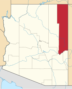
Bannon was an unincorporated community in Apache County, Arizona, United States. [1] It is now a ghost town. [2]

History

A post office called Bannon was established in 1920, and remained in operation until 1942. [3] The community has the name of James Bannon, a pioneer citizen. [4]

Related Research Articles

<span class="mw-page-title-main">Greenlee County, Arizona</span> County in Arizona, United States

Greenlee County is a county in the southeastern part of the U.S. state of Arizona. As of the 2020 census, the population was 9,563, making it Arizona's least populous county. The county seat is Clifton.

<span class="mw-page-title-main">Springerville, Arizona</span> Town in Apache County, Arizona, United States

Springerville is a town in Apache County, Arizona, United States, within the White Mountains. Its postal ZIP Code is 85938. As of the 2010 census, the population of the town was 1,961.

<span class="mw-page-title-main">Black Canyon City, Arizona</span> CDP in Yavapai County, Arizona, US

Black Canyon City is an unincorporated community and census-designated place (CDP) in Yavapai County, Arizona, United States. The population is 2,677 as of the 2020 census.

The Zuni (Zuñi) River is a tributary of the Little Colorado River in the southwestern United States. It has its origin in Cibola County, New Mexico, in the Zuñi Mountains at the Continental Divide. The river flows off the western slopes of the Zuñi Mountains in a generally southwesterly direction through the Zuni Indian Reservation to join the Little Colorado River in eastern Arizona. The Zuni River is approximately 90 miles (140 km) long, and has a drainage basin in New Mexico of approximately 1,300 square miles (3,400 km2).

<span class="mw-page-title-main">Catalyst Infoshop</span> Former infoshop and radical community center Arizona, US

The Catalyst Infoshop was an infoshop and bookshop at 109 N. McCormick Street, Prescott, Arizona, founded in 2004. It had closed by 2010.

Navajo Springs is an unincorporated community located on the Navajo Nation, near Holbrook, Arizona. The community is almost exclusively Native American, and a permit is required from the Navajo Nation for off-road travel in that area. During the time of the Old West, this area was frequented by notable western characters, such as Commodore Perry Owens. Navajo Springs was a stopping place for travelers to water their horses and themselves. The Beale Wagon Road, a precursor of the transcontinental railroad built through the area in 1882 as well as the "mother road", U.S. Route 66, ran through Navajo Springs. The Arizona territorial government was organized here, and later a monument at the springs was erected to commemorate the event. At the insistence of the Santa Fe Railway company, all Navajos were forcibly moved away from the Navajo Springs area, and by the 1930s, all allotted lands within the area were extinguished and the lands forcibly vacated. But by the late 1980s, the lands were once again occupied by Navajos, this time by Navajo "refugees" from the Navajo-Hopi land dispute.

<span class="mw-page-title-main">Eastern Arizona College</span> Community college in Graham County, Arizona

Eastern Arizona College (EAC), is a community college in Graham County, Arizona. The main campus is in Thatcher, with satellite locations in Gila County and Greenlee County. It is the oldest community college in Arizona and the only one in the state with a marching band.

<span class="mw-page-title-main">Fort Thomas, Arizona</span> CDP in Graham County, Arizona

Fort Thomas is a census-designated place in Graham County, Arizona, United States. Its population was 319 as of the 2020 census. The community has an elementary school and a high school. It is part of the Safford Micropolitan Statistical Area. Fort Thomas has a ZIP code of 85536.

Silver Creek is a 45-mile-long (72 km) stream located in the White Mountains of Arizona north of Show Low. It is a tributary of the Little Colorado River. It is also the site of a supervolcano that erupted 18.8 million years ago.

Blue is an unincorporated community in Greenlee County, Arizona, United States. It lies 33°36′36″N109°6′24″W, at an elevation of 5,758 feet (1,755 m).

Red Mesa High School is a high school in Red Mesa in an unincorporated area of Apache County, Arizona, near Teec Nos Pos. It is one of two high schools under the jurisdiction of the Red Mesa Unified School District, along with Red Valley/Cove High School.

San Simon River is an ephemeral river, or stream running through the San Simon Valley in Graham and Cochise County, Arizona and Hidalgo County, New Mexico. Its mouth is at its confluence with the Gila River at Safford in Graham County. Its source is located at 31°51′21″N109°01′27″W.

Groom Creek is an unincorporated community in Yavapai County, in the U.S. state of Arizona.

Alexandria is an unincorporated community in Scioto County, in the U.S. state of Ohio.

Eifort is an unincorporated community in Lawrence and Scioto counties, Ohio, United States.

Henley is an unincorporated community in Scioto County, in the U.S. state of Ohio.

Hondah is a census-designated place (CDP) in Navajo County, Arizona, United States, on the Fort Apache Indian Reservation. The population was 812 at the 2010 census.

Lake of the Woods is a census-designated place (CDP) in Navajo County, Arizona, United States, adjacent to the town of Pinetop-Lakeside. The population was 4,094 at the 2010 census.

North Fork is a census-designated place (CDP) in Navajo County, Arizona, United States, on the Fort Apache Indian Reservation. The population was 1,417 at the 2010 census.

Pinetop Country Club is a census-designated place (CDP) located in Navajo County, Arizona, United States. The population was 1,794 at the 2010 census.

References

  1. U.S. Geological Survey Geographic Names Information System: Bannon, Arizona
  2. Bannon, ghostowns.com
  3. "Post Offices". Jim Forte Postal History. Retrieved January 5, 2017.
  4. Barnes, Will Croft (1960). Arizona place names. University of Arizona Press. p. 4.
34°15′14″N109°44′33″W / 34.2539°N 109.7426°W / 34.2539; -109.7426