Swansea is a town in Bristol County in southeastern Massachusetts, United States. It is located at the mouth of the Taunton River, just west of Fall River, 47 miles (76 km) south of Boston, and 12 miles (19 km) southeast of Providence, Rhode Island. The population was 17,144 at the 2020 census. The villages of Hortonville, Barneyville and Ocean Grove are located in the town.

Duxbury is a historic seaside town in Plymouth County, Massachusetts, United States. A suburb located on the South Shore approximately 35 miles (56 km) to the southeast of Boston, the population was 16,090 at the 2020 census.

Pennellville Historic District is a residential district located in Brunswick, Maine. To locals, the neighborhood is known simply as "Pennellville."

The Smithfield Friends Meeting House, Parsonage and Cemetery, is a Friends Meeting House of the Religious Society of Friends (Quakers), rebuilt in 1881. It is located at 108 Smithfield Road in Woonsocket, Rhode Island. The meetinghouse is home to one of the oldest Quaker communities in the region.

The Providence Jewelry Manufacturing Historic District is a predominantly industrial historic district in Providence, Rhode Island. It covers a roughly 19-acre (7.7 ha) area in the city's Jewelry District, just south of Downtown Providence. While the area began as a residential neighborhood, it emerged in the late 19th and early 20th centuries as a center of Providence's jewelry manufacturing businesses. The oldest industrial building in the district is the 1848 Elm Street Machine Shop, a 2+1⁄2-story stone structure that now houses offices of Brown University.

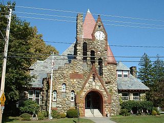
The First Baptist Church and Society is a historic Baptist church in Swansea, Massachusetts. The congregation, founded in 1663, is the oldest Baptist congregation in Massachusetts and one of the oldest in the United States.

The South Washington Street Historic District is a historic district encompassing 200 years of residential architecture in North Attleborough, Massachusetts. It extends along South Washington Street in the central portion of the town, between Elm Street in the north, and Sutherland Street in the south and includes two properties on Hunking Street. The district was added to the National Register of Historic Places in 1995.

The Norton House is a historic house located in northern Swansea, Massachusetts.

The Attleborough Falls Historic District is a predominantly residential historic district on Mt. Hope and Towne Streets in North Attleborough, Massachusetts. Located just south of the Ten Mile River, it encompasses a stylish mid-to-late 19th century residential area that developed in a previously rural area due to industrial development across the river. The district was added to the National Register of Historic Places in 2004.

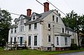
The William P. Mason House is a historic house located in Swansea, Massachusetts.

Luther's Corner is a historic district encompassing the original economic center of Swansea, Massachusetts. The district is centered on the junction of Old Warren and Pearse Roads, the former being a major stage route between Fall River and Providence, Rhode Island, and was for many years associated with the locally prominent Luther Family. Luther's Corner was added to the National Register of Historic Places in 1990.

The Commonwealth Avenue Historic District is a historic district on Commonwealth Avenue on the north side from Stanley Street to beyond Robinson Street in North Attleborough, Massachusetts. The area encompasses a variety of stylish 19th-century houses, as well as two 19th-century industrial buildings, depicting the proximity of wealthy industrial owners and managers to their factories. The district was added to the National Register of Historic Places in 2003.

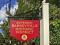
Hortonville is a village in the town of Swansea, Bristol County, Massachusetts, United States. The part of the village on Locust Street from Oak Street to Hortonville Road comprises the Hortonville Historic District, which was listed on the National Register of Historic Places in 1990.

The Myles Standish Burial Ground in Duxbury, Massachusetts is, according to the American Cemetery Association, the oldest maintained cemetery in the United States.

The Hollis Village Historic District encompasses the historic village center of Hollis, New Hampshire. The district is centered on Monument Square, which connects Main Street to Depot Street and Broad Street. It covers about 400 acres (160 ha), and extends along all three of those roads for some distance, and includes properties on Silver Lake Road and Ash Street. Most of the buildings in the district are residential or agricultural in use, and date before the turn of the 20th century; the oldest buildings date to the mid-18th century. The "Always Ready Engine House", which occupies a triangular parcel at the western end of Monument Square, was built in 1859, and is the town's oldest municipal building. Its most architecturally sophisticated building is the town hall, built in 1887 to a design by William M. Butterfield of Manchester. The district represents the growth of a mainly agricultural community over a 200-year period. The district was listed on the National Register of Historic Places in 2001.

The Mystic Bridge Historic District is a historic district in the village of Mystic, Connecticut on the Stonington side of the Mystic River. It includes the Mystic Seaport Museum, whose grounds and floating vessels represent the area's history, and the 1924 Mystic River Bascule Bridge. The district is significant as a well-preserved shipbuilding and maritime village of the 19th and early 20th centuries, and it was added to the National Register of Historic Places in 1979.

The Cove Street Historic District encompasses a small 19th-century neighborhood area of Duxbury, Massachusetts. Located along Cove Street north of the town center, it was developed in the early 19th century to provide housing for workers in nearby shipyards. The architecture of the district includes a variety of single-family housing styles common to the region and time period. The district was added to the National Register of Historic Places in 2019.

The Somerset Village Historic District is a historic district encompassing the historic town center of Somerset, Massachusetts. Settled in the 17th century, the village developed around a shipyard and pottery works, and became the town center when it was incorporated out of Swansea in 1790. Architecturally it is reflective mainly of its 19th-century growth, with stylistically diverse buildings. The district was added to the National Register of Historic Places in 2020.

Myles Standish Park is a municipal park in the town of Duxbury, Massachusetts. It consists of a 1-acre (0.40 ha) parcel of land encompassing the former site of the home of the early Pilgrim settler Myles Standish. The park was established in 1929 after the land was given to the town by the Myles Standish Monument Association. It was listed on the National Register of Historic Places in 2021.

Potrero Point is an area in San Francisco, California, east of San Francisco's Potrero Hill neighborhood. Potrero Point was an early San Francisco industrial area. The Point started as small natural land feature that extends into Mission Bay of San Francisco Bay. The Point was enlarged by blasted and cuts on the nearby cliffs. The cut material was removed and used to fill two square miles into the San Francisco bay, making hundreds of acres of flat land. The first factories opened at Potrero Point in the 1860s. Early factories were powder magazine plant, the Pacific Rolling Mill Company and small shipyards. The large Union Iron Works and its shipyards were built at the site, stated in 1849 by Peter Donahue. To power the factories and neighborhood coal and gas-powered electricity works were built, later the site became Pacific Gas and Electric Company (PG&E).