
John Harrison was an English carpenter and clockmaker who invented the marine chronometer, a long-sought-after device for solving the problem of how to calculate longitude while at sea.

North Lincolnshire is a unitary authority area with borough status in Lincolnshire, England. At the 2011 Census, it had a population of 167,446. The administrative centre and largest settlement is Scunthorpe, and the borough also includes the towns of Brigg, Broughton, Haxey, Crowle, Epworth, Bottesford, Winterton, Kirton in Lindsey and Barton-upon-Humber. North Lincolnshire is part of the Yorkshire and the Humber region. The borough is mostly rural in character aside from near the town of Scunthorpe and near the Port of Immingham where most of the nearby villages and towns form part of the wider urban areas.

Thornton Abbey was a medieval abbey located close to the small North Lincolnshire village of Thornton Curtis, near Ulceby, and directly south of Hull on the other side of the Humber estuary. Its ruins are a Grade I listed building, including notably England's largest and most impressive surviving monastic gatehouse.

Barton-upon-Humber or Barton is a town and civil parish in North Lincolnshire, England. The population at the 2011 census was 11,066. It is situated on the south bank of the Humber Estuary at the southern end of the Humber Bridge. It is 6 miles (10 km) south-west of Kingston upon Hull and 31 miles (50 km) north north-east of the county town of Lincoln. Other nearby towns include Scunthorpe to the south-west and Grimsby to the south-east.

Immingham is a town and civil parish in North East Lincolnshire, England, on the south-west bank of the Humber Estuary, six miles northwest of Grimsby.

The Barton line is a railway line in North and North East Lincolnshire, England. It runs from Barton-upon-Humber south east to Cleethorpes and was designated by the Department for Transport as a community rail line in February 2007. Barton station is near to the Humber Bridge. It is situated on the south bank of the Humber Estuary.

Stallingborough is a village and civil parish in North East Lincolnshire, England. The population of the civil parish at the 2011 census was 1,234.

New Holland is a village, civil parish and port on the Humber estuary in North Lincolnshire, England. In 2001 it had a population of 955, increasing marginally to 970 at the 2011 census.

Barrow Haven is a hamlet and small port in North Lincolnshire, England. It was the site of a former ferry crossing that spanned from the Humber Estuary to Hull, serving as a place for ships and boats crossing the Humber to moor away from the tidal flow. A port continues to exist nearby and the area's rail access is based at the Barrow Haven railway station, a stop on the Barton Line.
Thornton Curtis is a village and civil parish in the North Lincolnshire district of Lincolnshire, England, approximately 5 miles (8 km) south-east from the town of Barton-upon-Humber. The population at the 2011 census was 295.

Thornton Abbey railway station is close to the site of Thornton Abbey in North Lincolnshire, England.

Wootton is a small village and civil parish in North Lincolnshire, England. The population of the civil parish at the 2011 census was 475. It is situated 5 miles (8 km) south-east from Barton-upon-Humber, 7 miles (11 km) north-east from Brigg and 3 miles (5 km) north from Humberside Airport.
Barton Waterside is a village in North Lincolnshire, England. It is in the civil parish of Barton-upon-Humber. Barton Waterside consists of the former port area at the north end of Barton-upon-Humber. The Community is centred on Barton Haven - a late Anglo-Saxon artificial harbour - which was dug c.1000 AD to create a reliable deep water port for the extreme north of Lindsey. It seems possible that the project was initiated by Peterborough Abbey which had interests in the parish at that time.

St Peter's Church is the former parish church of Barton-upon-Humber in North Lincolnshire, England. It is one of the best known Anglo-Saxon buildings, in part due to its role in Thomas Rickman's identification of the style. It has been subject to major excavations. The former Church of England church is now run by English Heritage and houses an exhibition exploring its history.

Saxby All Saints is a village and civil parish in North Lincolnshire, England. The population of the civil parish at the 2011 census was 385. It is 6 miles (9.7 km) north of Brigg and 4 miles (6.4 km) south-west of Barton upon Humber.
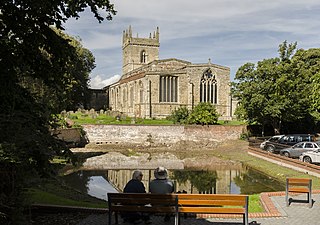
St Mary's Church is an Anglican church and Grade I Listed building in Barton-upon-Humber, North Lincolnshire, England.

Bardney Hall is an 18th-century residence and a Grade II* Listed building in Barton-upon-Humber, North Lincolnshire. It was constructed as a private residence for William Gildas in the early 1700s and is now used as a bed and breakfast.

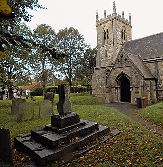
Church of Holy Trinity is an Anglican church and Grade I Listed building in Barrow upon Humber, North Lincolnshire, England.
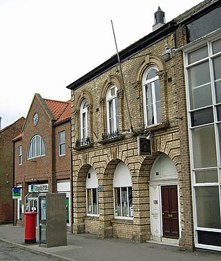
The Corn Exchange is a commercial building in the Market Place in Barton-upon-Humber, Lincolnshire, England. The structure, which is now used as a private members club, is a Grade II listed building.

