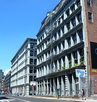
SoHo, sometimes written Soho, is a neighborhood in Lower Manhattan, New York City. Since the 1970s, the neighborhood has been the location of many artists' lofts and art galleries, and has also been known for its variety of shops ranging from trendy upscale boutiques to national and international chain store outlets. The area's history is an archetypal example of inner-city regeneration and gentrification, encompassing socioeconomic, cultural, political, and architectural developments.

Chelsea is a city in Suffolk County, Massachusetts, United States, directly across the Mystic River from Boston. At the 2020 census, Chelsea had a population of 40,787. With a total area of just 2.46 square miles, Chelsea is the smallest city in Massachusetts in terms of total area. It is the second most densely populated city in Massachusetts, behind Somerville, and is the city with the second-highest percentage of Latino residents in Massachusetts, behind Lawrence.

The Civic Center neighborhood of Los Angeles, California, is the administrative core of the City of Los Angeles, County of Los Angeles, and a complex of city, county, state, and federal government offices, buildings, and courthouses. It is located on the site of the former business district of the city during the 1880s and 1890s, since mostly-demolished.

Downtown Santa Ana (DTSA), also called Downtown Orange County, is the city center of Santa Ana, the county seat of Orange County, California. It is the institutional center for the city of Santa Ana as well as Orange County, a retail and business hub, and has in recent years developed rapidly as a regional cultural, entertainment and culinary center for Orange County.

Bellingham Square station is a Massachusetts Bay Transportation Authority (MBTA) Silver Line bus rapid transit (BRT) station located near Bellingham Square slightly north of downtown Chelsea, Massachusetts. The station has two accessible side platforms for buses on the SL3 route. The Boston and Maine Railroad and predecessor Eastern Railroad served Chelsea station at the same location from the mid-1850s to 1958. The MBTA opened Chelsea station on the Newburyport/Rockport Line in 1985. Prior to its 2010 cancellation, the Urban Ring Project planned for a circumferential BRT line with a stop at Mystic Mall. Planning continued for the Chelsea segment; a Silver Line extension to Mystic Mall was announced in 2013. Construction began in 2015, and SL3 service to the renamed Bellingham Square station began on April 21, 2018. Commuter rail service moved to the newly constructed Chelsea station on November 15, 2021.

Congregation Agudath Shalom, also known as Agudas Sholom the Walnut Street Synagogue or the Walnut Street Shul, is an active, historic Open Orthodox Jewish synagogue at 145 Walnut Street in Chelsea, Massachusetts.

Chelsea Garden Cemetery is a historic rural cemetery in Chelsea, Massachusetts. The cemetery was established in 1841 to provide the city a burying ground in the then-fashionable rural cemetery style, and was the first cemetery within the city limits. It was added to the National Register of Historic Places in 2001.

The Downtown Chelsea Residential Historic District is a historic district roughly bounded by Shurtleff, Marginal, and Division Streets and Bellingham Square in Chelsea, Massachusetts.

The West Gardner Square Historic District encompasses the historic commercial, civic and industrial downtown area of Gardner, Massachusetts. Developed industrially beginning in the early 19th century, the area now boasts a concentration of late 19th and early 20th century commercial, civic, and industrial architecture. It was listed on the National Register of Historic Places in 1985.

The Central New Bedford Historic District is one of nine historic districts in New Bedford, Massachusetts, United States. The district encompasses the city's central business district, built up during the time in the late 19th century when textiles had replaced whaling as the city's main industry. It is a 29-acre (12 ha) rectangular area bounded by Acushnet Avenue and the older New Bedford Historic District on the east, School Street to the south, Middle Street on the north and 6th Street in the west. It was added to the National Register of Historic Places in 1980.

The Broadway Historic District is located along Broadway in Saratoga Springs, New York, United States. It has a twofold character. The southern section is the commercial core of the city, with many of its important public and private buildings, most intact from its peak days as a resort town in that era. North Broadway is a residential neighborhood with many large Victorian houses built by frequent visitors to the town and its spas and racetrack.
The Central Troy Historic District is an irregularly shaped, 96-acre (39 ha) area of downtown Troy, New York, United States. It has been described as "one of the most perfectly preserved 19th-century downtowns in the [country]" with nearly 700 properties in a variety of architectural styles from the early 19th to mid-20th centuries. These include most of Russell Sage College, one of two privately owned urban parks in New York, and two National Historic Landmarks. Visitors ranging from the Duke de la Rochefoucauld to Philip Johnson have praised aspects of it. Martin Scorsese used parts of downtown Troy as a stand-in for 19th-century Manhattan in The Age of Innocence.

The Des Moines City Hall is a government building in Des Moines, Iowa, built in 1909 and 1910. It was individually listed on the National Register of Historic Places on November 10, 1977 as the Municipal Building, and became a contributing property in the Civic Center Historic District in 1988. The building serves as the seat for the government of the city of Des Moines. Beginning April 7, 2016, City Hall offices were temporarily relocated while the building underwent renovation. The construction was necessary to install modern heating, cooling, and sprinkler systems while preserving the historic character of the building. The project was expected to take 18–24 months. During that time, City Hall was closed to the public, and City offices moved to other nearby locations. Between February 26, 2018 and April 9, 2018, city offices moved back to City Hall.

The Chelsea Commercial Historic District is a historic district located along both sides of Main Street from Orchard to North Street in Chelsea, Michigan; the district also includes the adjacent 100 blocks of Jackson, East Middle, and West Middle Streets, as well as structures on Park, East, and Orchard Streets. It was listed on the National Register of Historic Places in 2011.

Mount Vernon Triangle is a neighborhood and community improvement district in the northwest quadrant of Washington, D.C. Originally a working-class neighborhood established in the 19th century, present-day Mount Vernon Triangle experienced a decline in the mid-20th century as it transitioned from residential to commercial and industrial use. The neighborhood has undergone significant and rapid redevelopment in the 21st century. It now consists mostly of high-rise condominium, apartment and office buildings. Several historic buildings in the neighborhood have been preserved and are listed on the National Register of Historic Places. Mount Vernon Triangle is now considered a good example of urban planning and a walkable neighborhood.
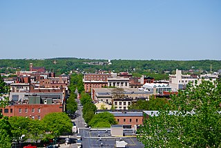
The Farmington Historic District encompasses much of the main central business district of Farmington, Maine. Farmington was settled in the 1770s, and experienced its most rapid growth after being named the shire town of Franklin County in 1838, with a secondary spurt of redevelopment after a major fire in the 1880s. Its central business district encompasses many of the town's historic resources, and its most significant commercial and civic architecture. The district, which includes more than 130 resource over 85 acres (34 ha), was listed on the National Register of Historic Places in 1995.

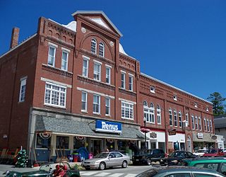
The Market Square Historic District of Houlton, Maine encompasses that town's historic late-19th century central business district. Centered on the junction of Market Square, Court Street, Water Street, and Main Street, it includes a relatively cohesive assortment of brick and masonry commercial buildings, designed by architects and built between 1885 and 1910, following the arrival of the Bangor and Aroostook Railroad. The district was listed on the National Register of Historic Places in 1980.

The Governor Shirley Square Historic District encompasses a cluster of civic, residential, and religious buildings at the junction of Dudley, Hampden, and Dunmore Streets in the Roxbury neighborhood of Boston, Massachusetts. Named for colonial governor William Shirley in 1913, the square was developed in the 1870s and 1880s as a major locus of civic development after the city of Roxbury was annexed to Boston in 1868. The district was listed on the National Register of Historic Places in 2016.

The Columbus Civic Center is a civic center, a collection of government buildings, museums, and open park space in Downtown Columbus, Ohio. The site is located along the Scioto Mile recreation area and historically was directly on the banks of the Scioto River.
The Humboldt Avenue Historic District is a historic district encompassing a cluster of multifamily brick buildings in the Dorchester neighborhood of Boston, Massachusetts. Centered on the junction of Humboldt Avenue and Hutchings Street, the area was developed in 1915-16 during a major Jewish migration, and includes a fine sample of Colonial Revival architecture. The district was listed on the National Register of Historic Places in 2021.


