Willow, cottonwood, chokecherry, and wild roses grow in part of the canyon stretch and in a large band in the foothill zone.[4] Brook, Brown, and Rainbow Trout have been introduced to the creek.[4] Native fish include several minnows, mooneye,perch, sculpin, 4 types of suckers, and 2 types of trout.[4]
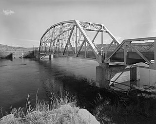
The Bighorn River is a tributary of the Yellowstone, approximately 461 miles (742 km) long, in the states of Wyoming and Montana in the western United States. The river was named in 1805 by fur trader François Larocque for the bighorn sheep he saw along its banks as he explored the Yellowstone.
The Yellowstone River is a tributary of the Missouri River, approximately 692 miles (1,114 km) long, in the Western United States. Considered the principal tributary of upper Missouri, via its own tributaries it drains an area with headwaters across the mountains and high plains of southern Montana and northern Wyoming, and stretching east from the Rocky Mountains in the vicinity of Yellowstone National Park. It flows northeast to its confluence with the Missouri River on the North Dakota side of the border, about 25 miles (40 km) west of Williston.
The Jefferson River is a tributary of the Missouri River, approximately 83 miles (134 km) long, in the U.S. state of Montana. The Jefferson River and the Madison River form the official beginning of the Missouri at Missouri Headwaters State Park near Three Forks. It is joined 0.6 miles (1.0 km) downstream (northeast) by the Gallatin.
The Madison River is a headwater tributary of the Missouri River, approximately 183 miles (295 km) long, in Wyoming and Montana. Its confluence with the Jefferson and Gallatin rivers near Three Forks, Montana forms the Missouri River.
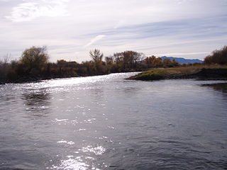
The Gallatin River is a tributary of the Missouri River, approximately 120 mi (193 km) long, in the U.S. states of Wyoming and Montana. It is one of three rivers, along with the Jefferson and Madison, that converge near Three Forks, Montana, to form the Missouri.
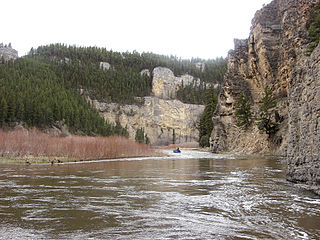
Smith River is a tributary of the Missouri River, in central Montana, in the United States. It rises in southern Meagher County in the Castle Mountains and flows northwest in the valley between the Big Belt and Little Belt mountains, past White Sulphur Springs and past Smith River State Park. It turns north-northwest (NNW), and is joined by Hound Creek in Cascade County, and joins the Missouri approximately 9 miles (14 km) southwest of Great Falls.
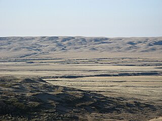
The Musselshell River is a tributary of the Missouri River, 341.9 miles (550.2 km) long from its origins at the confluence of its North and South Forks near Martinsdale, Montana to its mouth on the Missouri River. It is located east of the Continental divide entirely within Montana in the United States. Counting its pre-confluence tributaries, it measures 425–500 miles (684–805 km) in length.
Sixteen Mile Creek is a 69-mile (111 km) long tributary of the Missouri River in western Montana in the United States. It forms at the confluence of the Middle and South forks of Sixteen Mile Creek, approximately 6 miles (9.7 km) east of Maudlow. The canyon through which it travels is known as "Sixteen Mile Canyon". The abandoned grade of the Chicago, Milwaukee, St. Paul and Pacific Railroad parallels the creek through the canyon; the canyon is referred to as "Montana Canyon" in Milwaukee Road promotional material.
Arrow Creek is a tributary of the Missouri River in Montana in the United States. Approximately 45 miles (73 km) long, it rises in the Lewis and Clark National Forest near Highwood Baldy in the Highwood Mountains in southern Chouteau County. It flows south then east, then northeast and joins the Missouri in the White Cliffs Area on the border between Chouteau and Fergus counties.
The Judith River is a tributary of the Missouri River, approximately 124 mi (200 km) long, running through central Montana in the United States. It rises in the Little Belt Mountains and flows northeast past Utica and Hobson. It is joined by Dry Wolf Creek in northern Fergus County, and itself joins the Missouri in the White Cliffs Area approximately 18 mi (29 km) northwest of Winifred.
Big Sandy Creek is a tributary of the Milk River, approximately 50 miles long, in northwestern Montana in the United States.
The Teton River is a 64-mile-long (103 km) tributary of the Henrys Fork of the Snake River in southeastern Idaho in the United States. It drains through the Teton Valley along the west side of the Teton Range along the Idaho-Wyoming border at the eastern end of the Snake River Plain. Its location along the western flank of the Tetons provides the river with more rainfall than many other rivers of the region.
The Bitterroot River is a northward flowing 84-mile (135 km) river running through the Bitterroot Valley, from the confluence of its West and East forks near Conner in southern Ravalli County to its confluence with the Clark Fork River near Missoula in Missoula County, in western Montana. The Clark Fork River is a tributary to the Columbia River and ultimately, the Pacific Ocean. The Bitterroot River is a Blue Ribbon trout fishery with a healthy population of native westslope cutthroat trout and bull trout. It is the third most fly fished river in Montana behind the Madison and Big Horn Rivers.
The Gros Ventre, also known as the A'aninin, Atsina, or White Clay, are a historically Algonquian-speaking Native American tribe located in northcentral Montana. Today, the Gros Ventre people are enrolled in the Fort Belknap Indian Community of the Fort Belknap Reservation of Montana, a federally recognized tribe with 7,000 members, also including the Assiniboine people.
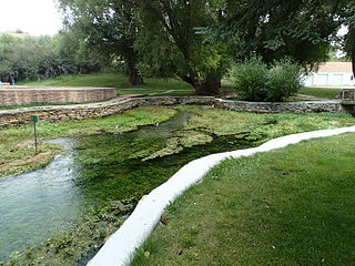
Giant Springs is a large first magnitude spring located near Great Falls, Montana and is the central feature of Giant Springs State Park. Its water has a constant temperature of 54 °F (12 °C) and originates from snowmelt in the Little Belt Mountains, 60 miles (97 km) away. According to chlorofluorocarbon dating, the water takes about 3,000 years to travel underground before returning to the surface at the springs.
Montana is one of the eight Mountain States, located in the north of the region known as the Western United States. It borders North Dakota and South Dakota to the east. Wyoming is to the south, Idaho is to the west and southwest, and the Canadian provinces of British Columbia, Alberta, and Saskatchewan are to the north, making it the only state to border three Canadian provinces.
The Little Belt Mountains are a section of the Rocky Mountains in the U.S. state of Montana. Situated mainly in the Lewis and Clark National Forest, the mountains are used for logging and recreation for the residents of Great Falls, Montana. Showdown is a ski area located within the mountains located off US Highway 89 which splits the mountains in half connecting White Sulphur Springs and Belt, MT. The highest point in the Little Belt Range is Big Baldy Mountain at 9,467 feet (2,886 m).
The Frenchman River,, also known locally as the Whitemud River, is a river in Saskatchewan, Canada and Montana, United States. It is a tributary of the Milk River, itself a tributary of the Missouri and, in turn, part of the Mississippi River watershed, which flows to the Gulf of Mexico.
Big Spring Creek is a tributary of the Judith River in Fergus County, Montana near Lewistown, Montana. The creek originates from a first magnitude artesian spring approximately 6 miles (9.7 km) south of Lewistown and flows north, northwest for 30 miles (48 km) to its confluence with the Judith River. The spring is one of the largest in the world flowing at approximately 50,000 to 64,000 US gallons per minute out of the Madison-Limestone formation in the foothills of the Big Snowy Mountains. The creek flows through and under the town of Lewistown. For three blocks spanning Main Street, the creek runs underneath the town in a man-made channel that was created as the town was built over the creek. The spring provides Lewistown's water supply, which requires no treatment for use by consumers.
Whitefish Lake ; is a natural oligotrophic freshwater lake in Flathead County, Montana, United States.
This page is based on this Wikipedia article Text is available under the CC BY-SA 4.0 license; additional terms may apply. Images, videos and audio are available under their respective licenses.