Claremont is a town in Brown County, South Dakota, United States. The population was 108 at the 2020 census.

Stratford is a town in southern Brown County, South Dakota, United States. The population was 57 at the 2020 census.

Westport is a town in western Brown County, South Dakota, United States. The population was 88 at the 2020 census.

Mound City is a town in and the county seat of Campbell County, South Dakota, United States. The population was 69 at the 2020 census.

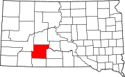
Wagner is a city in Charles Mix County, South Dakota, United States. The population was 1,490 at the 2020 census. The city is served by Wagner Municipal Airport as well as YST Transit buses.

Florence is a town in northwestern Codington County, South Dakota, United States. It is part of the Watertown, South Dakota Micropolitan Statistical Area. The population was 337 at the 2020 census.

Onaka is a town in Faulk County, South Dakota, United States. The population was 13 at the 2020 census.

Orient is a town in Faulk County, South Dakota, United States. The population was 51 at the 2020 census.

Stockholm is a town in Grant County, South Dakota, United States. The population was 102 at the 2020 census.

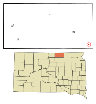
Hudson is a town in Lincoln County, South Dakota, United States. The population was 311 at the 2020 census. It is the easternmost community in South Dakota.
Wetonka is a town in McPherson County, South Dakota, United States. The population was 16 at the 2020 census.

Crooks is a city in Minnehaha County, South Dakota, United States and is a suburb of Sioux Falls. The population was 1,362 at the 2020 census. Crooks was named New Hope until 1904. The town's present name honors W. A. Crooks, a local politician.

Sherman is a town in Minnehaha County, South Dakota, United States. The population was 81 at the 2020 census.

Corona is a town in Roberts County, South Dakota, United States. The population was 69 at the 2020 census.

Ortley is a town in Roberts County, South Dakota, United States. The population was 50 according to the 2020 census.

Brentford is a town in Spink County, South Dakota, United States. The population was 88 at the 2020 census.

Tulare is a town in Spink County, South Dakota, United States. The population was 211 at the 2020 census.

Davis is a town in Turner County, South Dakota, United States. The population was 54 at the 2020 census.

Lowry is a town in Walworth County, South Dakota, United States. The population was 10 at the 2020 census. The town is home to Lowry Pilgrim Community Church, Swan Creek Harness Shop, J & C Repair, Karst Service and a fire station. Lowry also has an abandoned school, and a post office, which closed to service in the early 1970s.

Belvidere is a town in Lamoille County, Vermont, United States. The population was 358 at the 2020 census. Belvidere contains the hamlets of Belvidere Center, Belvidere Corners and Belvidere Junction. In 1963, part of Averys Gore in Franklin County became part of Belvidere, while the other part became part of Montgomery.