Last updated • 9 min readFrom Wikipedia, The Free Encyclopedia
You can help expand this article with text translated from the corresponding article in French. (December 2008)Click [show] for important translation instructions.
View a machine-translated version of the French article.
Machine translation, like DeepL or Google Translate, is a useful starting point for translations, but translators must revise errors as necessary and confirm that the translation is accurate, rather than simply copy-pasting machine-translated text into the English Wikipedia.
Do not translate text that appears unreliable or low-quality. If possible, verify the text with references provided in the foreign-language article.
You must provide copyright attribution in the edit summary accompanying your translation by providing an interlanguage link to the source of your translation. A model attribution edit summary is Content in this edit is translated from the existing French Wikipedia article at [[:fr:Bernières-sur-Mer]]; see its history for attribution.
You may also add the template {{Translated|fr|Bernières-sur-Mer}} to the talk page.
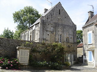
Bernières-sur-Mer is one of the oldest towns of the Côte de Nacre. Gallo-Roman traces are scattered on the territory of the municipality, and are visible in the cliffs of the "Cape Romain" east of the town. The Middle Ages saw the prosperity of Bernières - enjoying the magnificence of William the Conqueror. The Church of Bernières illustrates perfectly evolution of the region during the first half of the second millennium. In the early 20th century, served by the railway, its hotels and sandy beach, surrounded by dunes and the embankment welcomed visitors from across France.[5]
The town was liberated by The Queen's Own Rifles of Canada on 6 June 1944 as part of the leading assault wave of D-Day Operation Overlord.[6] Later, Le Régiment de la Chaudière, landed in reserve as part of the 8th Canadian Brigade, 3rd Canadian Division. The remains of the Atlantic Wall are still visible and are a place of remembrance where Berniérais honor each year the memory of the Canadians.
History: World War II
The Occupation
Across Calvados, the Occupation began a month before The June 1940 Armistice, it establishing first a German Occupied Zone and a Vichy Unoccupied Zone, retaining nominally the civil jurisdiction of Vichy over all of France, except for Alsace-Lorraine.[7][8] The (German) Military Command in France: Militärbefehlshaber in Frankreich (MBF), succeeding the Military Administration in France (Militärverwaltung in Frankreich), from the outset was the principal executive and decision-making protagonist in the (Northern) Occupied Zone. The presence of Vichy authorities allowed it to focus on the security of its occupying troops, and the efficient industrial economic exploitation of France.[9] The ‘Occupied Zone’ was divided into Military Administration Districts (Militärverwaltungsbezirk), with Regional Oberfeldkommandanturen, they into Departmental Military Administration (FK. Feldkommandanturen) and they into the Military Administration Prefecture (KK. Kreiskommandanturen. All initially employed the Feldgendarmerie (FG. German Military Police) having local police powers, and the Geheime Feldpolizei (GFP. Secret Field Police), conducting important investigations, and later the Sicherheitspolizei (Sipo. Security Police of the Sicherheitsdienst SD. Security Service), persons arrested appeared before military tribunals, which had been set up in each Département (FK).[9]
Bernières-sur-Mer sat inside the ‘Coastal Military Zone’ - set-out in the October 1941, along The Atlantic and The Channel Coasts, from the Basses-Pyrénées to the Pas-de-Calais / Nord; with a geographic depth extending up to 30km. First designated as ‘Entry Prohibited’ – restricted to those who had lived there for at least three months (principal residents), civil service Vichy personnel, those working for the German army, and the personnel of the SNCF.[10] In 1943 the MBK ordered a partial ‘evacuation’ of the Coastal Military Zone, in the interests of the French population "…en cas d'événements graves dans les communes." All residents designated non-essential to public services, industrial enterprises, agriculture, forestry and supply services, had to depart by 30 April, targeting the most vulnerable, children and the elderly; though enforcement was uneven. The CMZ was classified as ‘Entry Forbidden’- except to ‘essential civilians’ in April 1944, some cities and towns designated for evacuation.[11]
Basse Normandie fell within the rubric of Militärverwaltungsbezirk ‘Bezirk A’ - Nordwestfrankreich (North / West France) with its Headquarters (Stab) at Paris: St. Germain-en-Laye. Calvados-Baie de Seine came under an immediate Bezirk ‘A’ subordinate Oberfeldkommandanturen: Oberfeldkommandantur ‘Seine-Maritime’ (Stab. Rouen 1941).[12] With an Feldkommandantur FK established in each Canton Prefecture, working with the Department Préfet, FK 723 Caen (Feldpostnummer 12067) was created on 20 May 1940, it tasked with the upholding of order and security, taking measures to prevent sabotage and anti-German activity. Feldkommandantur FK 723 Caen its City KK, Kreis-Kommandantur 884 Caen responsible for coastal towns of the JUNO Sector, also oversaw the ‘sous-préfectures’ du Calvados: Kreis-Kommandantur 789 Bayeux, Kreis-Kommandantur 774 Lisieux, Kreis-Kommandantur 763 Vire.[13][14] This all changing in June 1942 with the arrival of The Sicherheitspolizei Sipo-SD Security Police and the centralization of repression, with their prime task of hunting of foreign agents. KdS (Kommandos der SIPO und des SD) were established across France, at the Regional (Provincial) Directorate Level. The Sipo-SD first established itself in Calvados through KdS Rouen (Seine-Maritime / Normandie) and its ‘Section Exterieures / Détachement’ Außendienststelle Caen (Département Calvados).[15]
At the beginning of the Battle of Normandy, the 3rd Canadian Infantry Division, commanded by Major General Rodney Keller, landed 15,000 Canadians and 9,000 British troops on the Calvados coast. Bernières-sur-Mer, one of five Canadian landing sites, was located to the eastern end of Canada's assigned landing sector of Juno Beach. On D-Day, the 8th Canadian Infantry (Assault) Brigade Group, stormed the beach, landing The Queen's Own Rifles of Canada, the 10th Armoured Regiment (The Fort Garry Horse), and the guns of the 14th Canadian Field Regiment, RCA, to engage troops of the Bataillon II./Grenadier-Regiment 736, who garrisoned the town's fortified 'Resistance Nest'.
Widerstandnesten WN 28 (NAN White) was located at North 49.335696 Degrees / West 00.419942 Degrees and in June 1944 for targeting purposes was at: LCC MR Grid 997855 (Ref. GSGS 4250 1:50K: Creully Sheet 7E/5). The (WN) Resistance Nest at Bernières-sur-Mer was a reinforced platoon sized position, incorporating multiple concrete (Verstärkt Feltmessig: Vf Type 2) gun casemates, with additional observation and crewed fighting positions, located to dominate the beach exits, into town.[16] A well prepared position, extending across much of the beach front, Hauptmann Rudolf Gruter, Kdr Kompanie 5./ Grenadier-Regiment 736./ Bataillon II., and his Ko Stab Gruppen located in Bernières, was well engaged, under naval bombardment, from before the Canadian H-Hr (07h55 BST). Having a wider frontage, the crew served weapon sites were not joined by an integrated network of trenches, but its rear was ‘protected’ by three fences of barbed wire. Approaches into the position were protected by three K.V. Gruppe Courseulles minefields. The left front (NW) sea approach, and beachfront, above the left seawall were protected by a large Beach Minefield: Mf 58. The right front (NE) land approach was protected Beach Minefield: Mf 57 and its rear and right flank by tactical minefield: Mf 55. A battalion heavy mortar detachment (Nest fur schweren Granatenwerfer) located 150 yards behind the beach, additionally supported the position, it protected by an anti-vehicle ditch, south of the railway line.[17]
The coastline on which NAN White was set out is low lying, from Courseulles to Bernieres sur Mer there was a sandy beach with short groynes to prevent lateral movement of sand by the current. Offshore all the way along the coast eastwards of Bernieres sur Mer there were rocky outcrops parts of which were exposed at low tide: les Iles de Bernieres.[18] WN 28 began to take indirect fire, from the LCT(Mk4) embarked SP (105mm) artillery of 14th Canadian Field Regiment, RCA from 07h44 BST, it having little effect on the defenders at MR 998852, as the position included five Unterstands Type R501/R502 Personnel Shelters. For 35 minutes they fired a steady barrage onto the beaches (H-30 to H+5), it not as tight as had been attained in some training exercises.[19]
As programmed two volleys of 5" Rocket Fire then arrived, to disrupt any movement about the position, and a volley of 60lb Hedgerows fell about the flanks, cutting the wire entanglements and detonating the mines, securing the approaches onto the position and its casemates.[20] Because the tide was much higher than expected and the beach narrow and congested, the assaulting companies did not initially benefit from direct fire support from ‘B’ Squadron, 10th Canadian Armoured Regiment, The Fort Garry Horse, as they did not arrive as planned.[21]
The Resistance Nest was overcome by two companies of The Queen's Own Rifles of Canada, its ‘A’ Company (O.C. Major H. E. Dalton) landing at 08h12, west of WN 28a, (at MR Grid 989855) on an ‘open’ left flank, an unguarded German flank seldom to be found. Intending to land east of the town, between Bernières and St Aubin, ‘B’ Company (O.C. Major C.O. Dalton) landed directly on the edge of WN 28, at 08h15, taking 65 serious casualties, 200 yards east of their intended landing site (at MR Grid 998995).[22] ‘A’ Company got off the beach quickly, taking heavy machine gun fire, over the grass fields, just east of WN 28, it reaching the railway line. Having been being pinned down by heavy mortar fire, by 08h45 BST, it 'cleared' the road through the village at its southwest point.[23] A weakened ‘B’ Company scaled the sea wall, got off the beach, and outflanking the most serious threats, got into town by 09h00 BST, having seen some support from 'B' Squadron engaging casements and weapon-pits from their beach positions.[24]
79 Armoured Division (UK) Assault Engineers, having landed two AVRE Teams it was almost 09h30 before the exits were open and 'B' Squadron could move into town to support of 'B' and 'A' Companies.[25] Between 09h10 and 09h30, the self-propelled guns of 14th Field Regiment, RCA landed onto a narrow, crowded, and chaotic beach. Three batteries getting off the beach, they had 18 guns in action, to the right of Bernières by 11h30. The regiment spent most of the day in action in improvised gun areas close to Bernières, crest clearances hampering the action of the guns.[26] Receiving the worst battering of any Canadian unit on D-Day, the Queen's Own Rifles suffered 60 killed and 78 wounded, in the fight for Bernières-sur-Mer.[27]
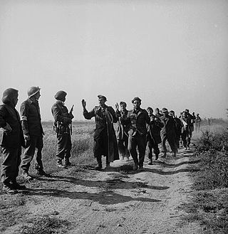
German Crew Served Weapons at WN 28 Bernières-sur-Mer. The casements took innumerable direct hits, doing little more than denting the concrete.[28][29]
WN 28b at Bernières-sur-Mer (West) was located at North 49Deg 20Min 04Sec and West 00Deg 25Min 40Sec and in June 1944 for targeting purposes was at: LCC MR Grid 993855 (Ref. GSGS 4250 1:50K: Creully Sheet 7E/5). Sited west of the town, supporting his left flank, Hauptmann Rudolf Gruter, of Ko 5./ Bataillon II./ 736., had sited a Log Type Feltmessige Anlage: Fa)Crib Timber and Earth Field Emplacement, to shelter two 50mm PaK 38 Anti-Tank Guns.[30][31] It did not contribute to fight at Bernières-sur-Mer (WN28), having been neutralized by the Task Force ‘J’ Naval Beach Bombardment Drenching Fire Programme, this before H-Hr at 07h55 BST. The landing of ‘A’ Company, The Queen's Own Rifles of Canada, at MR Grid 989855, occurred west of this now abandoned position.[22]
Juno and or Juno Beach was one of five beaches of the Allied invasion of German-occupied France in the Normandy landings on 6 June 1944 during the Second World War. The beach spanned from Courseulles, a village just east of the British beach Gold, to Saint-Aubin-sur-Mer, and just west of the British beach Sword. Taking Juno was the responsibility of the First Canadian Army, with sea transport, mine sweeping, and a naval bombardment force provided by the Royal Canadian Navy and the British Royal Navy as well as elements from the Free French, Norwegian, and other Allied navies. The objectives of the 3rd Canadian Infantry Division on D-Day were to cut the Caen-Bayeux road, seize the Carpiquet airport west of Caen, and form a link between the two British beaches on either flank.
Calvados is a department in the Normandy region in northwestern France. It takes its name from a cluster of rocks off the Normandy coast. In 2019, it had a population of 694,905.
Bény-sur-Mer is a commune in the Calvados department in the Normandy region, in northwestern France. It lies 5 km south of Bernières-sur-Mer and 13 km north of Caen.
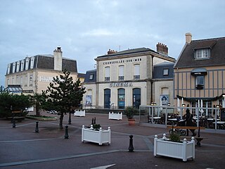
Courseulles-sur-Mer, commonly known as Courseulles, is a commune in the Calvados department, Normandy, northwestern France. Until 1957, the town's name was simply Courseulles. It lies 3 km west of Bernières-sur-Mer and 18 km north of Caen.
Graye-sur-Mer is a commune in the Calvados department in the Normandy region, in northwestern France. It lies 1 km west of Courseulles-sur-Mer, and 18 km east of Bayeux.
Reviers is a commune in the Calvados department in the Normandy region, in northwestern France. It lies 4 km south of Courseulles-sur-Mer and 15 kn northwest of Caen. It lies at the confluence of the rivers Seulles and Mue. There is bridge west of Reviers, crossing the Seulles, on the principal road (D176) connecting to Colombiers-sur-Seulles, and a bridge in Reviers, crossing the Mue, on the principal road (D35), connecting east to Tailleville.
Saint Aubin-sur-Mer is a commune in the Calvados department, in northwestern France. Administratively, it is part of the arrondissement of Caen and the canton of Courseulles-sur-Mer. It is 2.1 km east of Bernières-sur-Mer, 4 km north of Douvres-la-Délivrande and 16 km north of Caen.
The 3rd Canadian Division is a formation of the Canadian Army responsible for the command and mobilization of all army units in the provinces of Manitoba, Saskatchewan, Alberta and British Columbia, as well as Northwestern Ontario including the city of Thunder Bay.
Ver-sur-Mer is a commune in the Calvados department and Normandy region of north-western France. It is situated at the eastern end of Gold Beach between Arromanches and Courseulles. The town lies 20 km north-west of Caen and 14 km north-east of Bayeux.
The 716th Static Infantry Division was a World War II, German Army infantry division. It was raised on May 2, 1941, and sent to German-occupied France in June 1941. Many of the division's troops were elderly Germans and conscripts from other German-occupied countries. The division also had some young German conscripts as well. As a bodenständig it was not equipped with the standard configuration of vehicles and heavy weapons. Much of the division's artillery and anti-tank guns were from captured armaments.
The Juno Beach Centre is a museum located in Courseulles-sur-Mer in the Calvados region of Normandy, France. It is situated immediately behind the beach codenamed Juno, the section of the Allied beachhead on which 14,000 Canadian troops landed on D-Day 6 June 1944.
George Kenneth "Ken" Bell was a Canadian photographer who served with the Canadian armed forces during the Second World War. As a Lieutenant in the Canadian Army Film and Photo Unit, he participated in the Normandy Landings, disembarking at Juno Beach on June 6, 1944, with the Highland Light Infantry of Canada. Later he went on to photograph and record the liberation of France, Belgium and the Netherlands, and finally documented the occupation of Germany. After the war he had a successful career as a professional photographer, and published a number of books including Not in Vain, a collection of photographs showing the changes which had taken place in Europe since the end of the war.
Banville is a commune in the Calvados department in the Normandy region of north-western France.
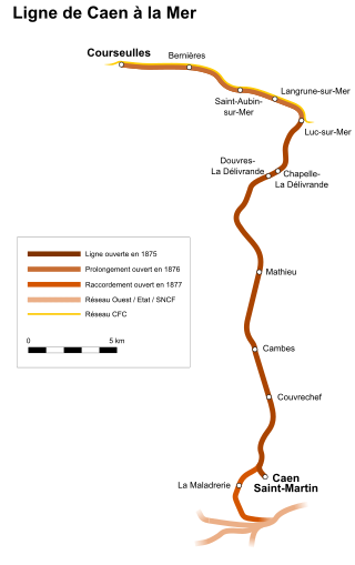
The Compagnie du chemin de fer de Caen à la mer (CM) was an early French railway company.
The Bény-sur-Mer Canadian War Cemetery is a burial ground containing predominantly Canadian soldiers killed during the early stages of the Battle of Normandy in the Second World War. It is located in, and named after, Bény-sur-Mer, in the Calvados department, near Caen, in lower Normandy. As is typical of war cemeteries in France, the grounds are landscaped and kept. Contained within the cemetery is a cross of sacrifice, a monument typical of memorials designed by the Commonwealth War Graves Commission.
The Canadian Army Film and Photo Unit (CFPU) was a Canadian Army unit founded in 1941 in order to document military operations during World War II. It was the last unit of its kind to be founded by the Allied armies. Among the campaigns which it recorded were the invasion of Sicily, the D-Day landings, the liberation of Paris and the Elbe River link-up of the Allied armies, known as 'Elbe Day'.
The 7th Canadian Infantry Brigade was an infantry brigade of the Canadian Army that fought during World War I and World War II. The brigade, along with the 8th Canadian Infantry Brigade and the 9th Canadian Infantry Brigade, formed the 3rd Canadian Infantry Division. The division was formed in late 1915 in France and served on the Western Front until the armistice in November 1918. Later, during World War II, it arrived in the United Kingdom in 1940 and spent three years in garrison duties and training in preparation for the assault landings on Juno Beach in Normandy on 6 June 1944. After fighting in Normandy, the brigade took part in the Battle of the Scheldt. After the war, it served on occupation duties until being disbanded in June 1946.
The 8th Canadian Infantry Brigade was an infantry brigade of the Canadian Army that saw active service during World War I and World War II as part of the 3rd Canadian Infantry Division. The brigade fought on the Western Front during World War I from December 1915 to November 1918, and in Normandy and north-west Europe in 1944–1945 during World War II. It was a square formation of four infantry battalions during World War I, but was reduced to a triangular formation of three battalions during World War II.
This is the Juno Beach order of battle on D-Day.
The Battle of Douvres Radar Station was a military engagement of the Invasion of Normandy, that took place on 17 June 1944. The radar had been destroyed on the first day and Allied troops had bypassed the site moving further inland.
↑ Lt. R.H. Roy, Report No. 54 - Historical Section (G.S.) Army Headquarters. Canadian Participation in the Operations in North-West Europe, 1944. Part 1: The Assault and subsequent operations of 3 Cdn Inf Div. Appendix H. Dated 3 December 45. Accessed 10.08.2016.
↑ Lt. R.H. Roy, Report No. 54 - Historical Section (G.S.) Army Headquarters. Canadian Participation in the Operations in North-West Europe, 1944. Part 1: The Assault and Subsequent Operations of 3 Cdn Inf Div. Annex ‘D’- Dated 30 Jun 52. Accessed 28.01.2018
↑ Anderson, Richard C., Cracking Hitler's Atlantic Wall: The 1st Assault Brigade Royal Engineers on D-Day, Stackpole Books, Mechanicsburg, PA., 2010, ISBN9780811742719, Chapter 4 German Planning and Preparation: The German Defences - Page 73. Accessed 18.05.2016
↑ Anderson Richard C., Cracking Hitler's Atlantic Wall: The 1st Assault Brigade Royal Engineers on D-Day, Stackpole Books, Mechanicsburg, PA., 2010, ISBN9780811742719, Chapter 4 German Planning and Preparation: The German Defences - Page 73. Accessed 18.05.2016
This page is based on this Wikipedia article Text is available under the CC BY-SA 4.0 license; additional terms may apply. Images, videos and audio are available under their respective licenses.