Basly

Last updated • 2 min readFrom Wikipedia, The Free Encyclopedia

Basly
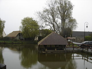
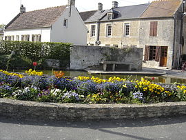
Ancien lavoir a Basly.JPG
The old Lavoir at Basly
Location of Basly
Basly
France location map-Regions and departements-2016.svg
Red pog.svg
Basly
Normandie region location map.svg
Red pog.svg
Basly
Coordinates: 49°16′48″N0°25′19″W / 49.28°N 0.4219°W / 49.28; -0.4219
Country France
Region Normandy
Department Calvados
Arrondissement Caen
Canton Courseulles-sur-Mer
Intercommunality Cœur de Nacre
Government
  Mayor (20202026) Yves Gauquelain
Area
1
3.92 km2 (1.51 sq mi)
Population
 (2021) [1]
1,057
  Density270/km2 (700/sq mi)
Time zone UTC+01:00 (CET)
  Summer (DST) UTC+02:00 (CEST)
INSEE/Postal code
14044 /14610
Elevation18–62 m (59–203 ft)
(avg. 70 m or 230 ft)
1 French Land Register data, which excludes lakes, ponds, glaciers > 1 km2 (0.386 sq mi or 247 acres) and river estuaries.

Basly (French pronunciation: [bali] ) is a commune in the Calvados department in the Normandy region of north-western France. [2]

Contents

The inhabitants of the commune are known as Basliens or Basliennes. [3]

Geography

Basly is located some 6 km south-east of Courseulles-sur-Mer and 10 km north-west of Caen. Access to the commune is by the D79 road from Bény-sur-Mer in the north-east which passes through the village and continues south-east to Colomby-sur-Thaon. The D83 comes from Douvres-la-Délivrande in the north-east through the village then south-west to Thaon. The D404 passes through the north-east corner of the commune and the D141 from Fontaine-Henry to Colomby-sur-Thaon passes through the south-west corner. The commune is entirely farmland. [4] [5]

The Mue river forms the border of the south-western corner of the commune as it twists around then flows north-west to join the Seulles at Reviers. [4] [5]

History

At a place called Campagne in the commune (near the Moto-Club) many archaeological remains have been found. This is on a spur blocked by the valley of the Mue. The most famous remains are those of a habitat from the first Iron Age (the Hallstatt culture) with an associated rectangular necropolis. There is archaeological evidence of a Neolithic stockade in medieval times.

Basly appears as Basly on the 1750 Cassini Map [6] and the same on the 1790 version. [7]

Administration

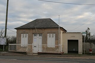
Basly Town Hall Mairie de Basly et son portail.JPG
Basly Town Hall

List of Successive Mayors [8]

FromToNamePartyPosition
18001844Louis
18601879Paisant
18791891Viel
18941896Maillard
18941896Viel
18961903Legras
19031904Marie
19421953Leboucher
19531959Marie
19591965Leboucher
19651971Marie
19711979Vauvert
19791983Coutard
19831989Lemarchand
19892008François Oudin
20082026 [9] [10] Yves GauquelainRetired

The Municipal Council is composed of 15 members including the Mayor and 4 deputies. [11]

Demography

In 2017 the commune had 1,105 inhabitants.

Historical population
YearPop.±% p.a.
1793 511    
1800 500−0.31%
1806 546+1.48%
1821 518−0.35%
1831 444−1.53%
1836 466+0.97%
1841 439−1.19%
1846 427−0.55%
1851 440+0.60%
1856 446+0.27%
1861 448+0.09%
1866 385−2.99%
1872 370−0.66%
1876 389+1.26%
1881 377−0.62%
1886 343−1.87%
1891 326−1.01%
1896 285−2.65%
YearPop.±% p.a.
1901 263−1.59%
1906 269+0.45%
1911 252−1.30%
1921 217−1.48%
1926 202−1.42%
1931 211+0.88%
1936 213+0.19%
1946 241+1.24%
1954 258+0.86%
1962 237−1.06%
1968 272+2.32%
1975 383+5.01%
1982 672+8.36%
1990 633−0.74%
1999 657+0.41%
2007 910+4.16%
2012 1,137+4.55%
2017 1,105−0.57%
Source: EHESS [12] and INSEE [13]

Culture and heritage

Religious heritage

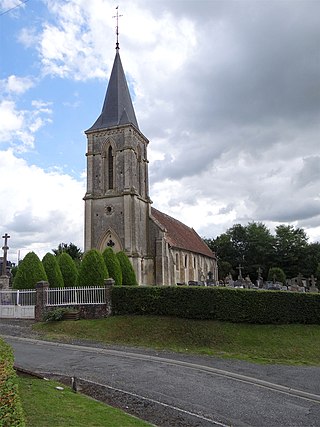
The Church bell tower Le clocher porche de l'eglise de Basly.JPG
The Church bell tower

The Church of Saint Georges Bell Tower (12th century) Logo monument historique - rouge sans texte.svg is registered as an historical monument. [14]

Festivals and events

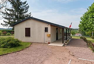
The Town Hall garden Le jardin de la mairie.JPG
The Town Hall garden

Sports

Notable people linked to the commune

See also

Related Research Articles

<span class="mw-page-title-main">Anctoville</span> Part of Aurseulles in Normandy, France

Anctoville is a former commune in the Calvados department in the Normandy region of north-western France. On 1 January 2017, it was merged into the new commune Aurseulles.

<span class="mw-page-title-main">Angerville, Calvados</span> Commune in Normandy, France

Angerville is a commune in the Calvados department in the Normandy region of northwestern France.

<span class="mw-page-title-main">Anguerny</span> Part of Colomby-Anguerny in Normandy, France

Anguerny is a former commune in the Calvados department in the Normandy region of northwestern France. On 1 January 2016, it was merged into the new commune of Colomby-Anguerny.

<span class="mw-page-title-main">Arganchy</span> Township in Normandy, France

Arganchy is a commune in the Calvados department in the Normandy region of northwestern France.

<span class="mw-page-title-main">Asnières-en-Bessin</span> Commune in Normandy, France

Asnières-en-Bessin is a commune in the Calvados department in the Normandy region of north-western France.

<span class="mw-page-title-main">Auberville</span> Commune in Normandy, France

Auberville is a commune in the Calvados department in the Normandy region of north-western France.

<span class="mw-page-title-main">Barbeville</span> Commune in Normandy, France

Barbeville is a commune in the Calvados department in the Normandy region of north-western France.

<span class="mw-page-title-main">Barneville-la-Bertran</span> Commune in Normandy, France

Barneville-la-Bertran is a commune in the Calvados department in the Normandy region of north-western France.

<span class="mw-page-title-main">Baron-sur-Odon</span> Commune in Normandy, France

Baron-sur-Odon is a commune in the Calvados department in the Normandy region of north-western France.

<span class="mw-page-title-main">Barou-en-Auge</span> Commune in Normandy, France

Barou-en-Auge is a commune in the Calvados department in the Normandy region of north-western France.
<span class="mw-page-title-main">Basseneville</span> Commune in Normandy, France

Basseneville is a commune in the Calvados department in the Normandy region of north-western France.

<span class="mw-page-title-main">Bauquay</span> Part of Les Monts dAunay in Normandy, France

Bauquay is a former commune in the Calvados department in the Normandy region of north-western France. On 1 January 2017, it was merged into the new commune Les Monts d'Aunay.
<span class="mw-page-title-main">Bavent</span> Commune in Normandy, France

Bavent is a commune in the Calvados department in the Normandy region of north-western France.
<span class="mw-page-title-main">Beaufour-Druval</span> Commune in Normandy, France

Beaufour-Druval is a commune in the Calvados department in the Normandy region of north-western France.

<span class="mw-page-title-main">La Bazoque, Calvados</span> Commune in Normandy, France

La Bazoque is a commune in the Calvados department in the Normandy region of north-western France.

<span class="mw-page-title-main">Beaufort, Isère</span> Commune in Auvergne-Rhône-Alpes, France

Beaufort is a commune in the Isère department in the Auvergne-Rhône-Alpes region of south-eastern France.
<span class="mw-page-title-main">Barrais-Bussolles</span> Commune in Auvergne-Rhône-Alpes, France

Barrais-Bussolles is a commune in the Allier department in the Auvergne-Rhône-Alpes region of central France.

<span class="mw-page-title-main">Baulou</span> Commune in Occitanie, France

Baulou is a commune in the Ariège department in the Occitanie region of south-western France.

Bassignac-le-Bas is a commune in the Corrèze department in the Nouvelle-Aquitaine region of south-central France.

<span class="mw-page-title-main">Baulme-la-Roche</span> Commune in Bourgogne-Franche-Comté, France

Baulme-la-Roche is a commune in the Côte-d'Or department in the Bourgogne-Franche-Comté region of eastern France.
References

  1. "Populations légales 2021" (in French). The National Institute of Statistics and Economic Studies. 28 December 2023.
  2. INSEE commune file
  3. Inhabitants of Calvados (in French)
  4. 1 2 3 Basly on Google Maps
  5. 1 2 Basly on the Géoportail from National Geographic Institute (IGN) website (in French)
  6. Basly on the 1750 Cassini Map
  7. Basly on the 1790 Cassini Map
  8. List of Mayors of France (in French)
  9. Reelection 2014: Basly (14610) 2014, Ouest-France, consulted on 8 June 2014 (in French)
  10. "Répertoire national des élus: les maires". data.gouv.fr, Plateforme ouverte des données publiques françaises (in French). 2 December 2020.
  11. art L. 2121-2 of the General Code of Collective Territories (in French).
  12. Des villages de Cassini aux communes d'aujourd'hui: Commune data sheet Basly, EHESS (in French).
  13. Population en historique depuis 1968, INSEE
  14. Ministry of Culture, Mérimée PA00111039 Church of Saint Georges Bell Tower (in French)
  15. Official website of the Basse-Normandie League – FC Basly, consulted on 27 March 2014 (in French)
  16. Moto-club of Basly website Archived 2011-02-02 at the Wayback Machine , consulted on 27 August 2010 (in French)