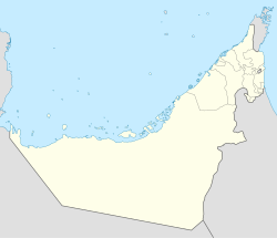
The United Arab Emirates (UAE) is a country in the eastern part of the Arabian Peninsula located on the southeastern coast of the Persian Gulf and the northwestern coast of the Gulf of Oman. The UAE consists of seven emirates and was founded on 2 December 1971 as a federation. Six of the seven emirates combined on that date. The seventh, Ras al Khaimah, joined the federation on 10 February 1972. The seven sheikdoms were formerly known as the Trucial States, in reference to the treaty relations established with the British in the 19th Century.

Fujairah is one of the seven emirates that make up the United Arab Emirates, and the only one of the seven that has a coastline solely on the Gulf of Oman and none on the Persian Gulf. The capital is Fujairah City.

Umm Al Quwain is the least populous of the seven constituent emirates in the United Arab Emirates, located in the north of the country. The emirate is ruled by Saud bin Rashid Al Mualla. It had 72,000 inhabitants in 2007 and has an area of 770 km2 (300 sq mi).
Dibbā is a coastal area at the northern tip of the eastern Arabian peninsula on the Gulf of Oman. It is politically divided into three segments:

Masafi is a village located on the edge of the Hajar Mountains in the United Arab Emirates. It sits at the inland entrance of the Wadi Ham, which runs down to Fujairah City. The border between the emirates of Fujairah and Ras Al Khaimah runs through the town, which houses a barracks used by the UAE's Union Defence Force.

Khor Fakkan is a city in Sharjah, located on the east coast of the United Arab Emirates (UAE). Sharjah is the only one of the seven emirates that faces both the Persian Gulf and the Gulf of Oman. The city, the second largest on the east coast after Fujairah, is set on the picturesque bay of Khor Fakkan, which means "Creek of Two Jaws". Khor Fakkan is an enclave of the Emirate of Sharjah, being geographically surrounded by the emirate of Fujairah. It is the site of Khor Fakkan Container Terminal, the only natural deep-sea port in the region and one of the major container ports in the UAE.

Hatta is the inland exclave of the emirate of Dubai in the United Arab Emirates.
Jazirat Badiyah is an island or peninsula near Al Badiyah and Zubara in the Emirate of Fujairah, United Arab Emirates.
Al Hayl is a suburb of Fujairah, United Arab Emirates (UAE), at the mouth of the Wadi Hayl. It is traditionally the home of the Kunud tribe.

The Al Badiyah Mosque is the oldest extant mosque in the United Arab Emirates or Fujairah. It is located in a small village in emirate Fujairah about 50 km north from region center. It is also known as Ottoman Mosque.۔
Al Bithnah is a village in Fujairah, United Arab Emirates (UAE), long occupying a strategic location in the Wadi Ham, which is the only natural link to the interior of the UAE and the Persian Gulf from the East Coast city, and Emirate, of Fujairah.

Rumailah is an archaeological site in Al Ain, UAE, as well as the site of a thick-walled coral and adobe fort, thought to date to the early 20th century.
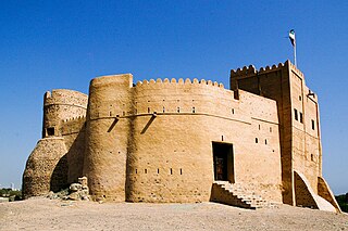
Fujairah Fort is a fort in the city of Fujairah, United Arab Emirates (UAE). Dating back to the 16th century, it is the among the oldest as well as the largest castles in the country. It is noted for playing significant roles in fighting back the wave of colonialism. Today, it is among the main tourist attractions in the city. It is probably the oldest fort in the UAE and was occupied by the Wahhabists.
Fujairah City is the capital of the emirate of Fujairah in the United Arab Emirates, located on the Gulf of Oman.
Fujairah Museum is an archaeology and local history museum located in Fujairah City, Emirate of Fujairah, United Arab Emirates.

Qattara Oasis is an area of irrigated date farm in Al Ain, United Arab Emirates featuring a distinctive falaj irrigation system as well as a late Bronze Age archaeological site dated to 1800–1500 BCE. The oasis has been extensively surveyed by students from Al Ain University since 2015, and is home to 19 buildings of varying antiquity, of which nine are mosques. Among these are thought to be some of the oldest buildings still standing in Al Ain.
The area currently known as the United Arab Emirates (UAE) was formerly populated by inhabitants of a number of coastal and inland settlements, with human remains pointing to a pattern of transmigration and settlement as far back as 125,000 years. Prehistoric settlement in the UAE spanned the Neolithic, with a number of distinctive eras of ancient settlement including the Stone Age Arabian Bifacial and Ubaid cultures from 5,000 to 3,100 BCE; the Hafit period with its distinctive beehive shaped tombs and Jemdet Nasr pottery, from 3,200 to 2,600 BCE; the Umm Al-Nar period from 2,600 to 2,000 BCE; the Wadi Suq Culture from 2,000–1,300 BCE and the three Iron Ages of the UAE.
The territory currently known as the United Arab Emirates was home to three distinct Iron Age periods. Iron Age I spanned 1,200–1,000 BCE, Iron Age II from 1,000–600 BCE, and Iron Age III from 600–300 BCE. This period of human development in the region was followed by the Mleiha or Late Pre-Islamic era, from 300 BCE onwards through to the Islamic era which commenced with the culmination of the 7th century Ridda Wars.