Anosy is one of the 22 regions of Madagascar. It is located in the southeast of the country, on the eastern side of what was once the Toliara Province. The name Anosy means "island(s)" in Malagasy.
Due to a strategic sea route running along its coast, Anosy had been an important crossroads for the Malagasy, Muslims, and Europeans. In the mid-1600s, it was the location of the first French colonial settlement in the Indian Ocean. The region was part of the Imerina Kingdom for much of the 1800s and part of the French colony of Madagascar from the late 1800s to 1960.
The region suffers from poverty; 80% of inhabitants lack access to clean water, 16% suffer from serious respiratory illnesses, and literacy is less than 20%.[4]
General references for the geography section: Vincelette et al. (2008)[5] and is primarily about the immediate Tôlanaro region.[6][7][8][9]
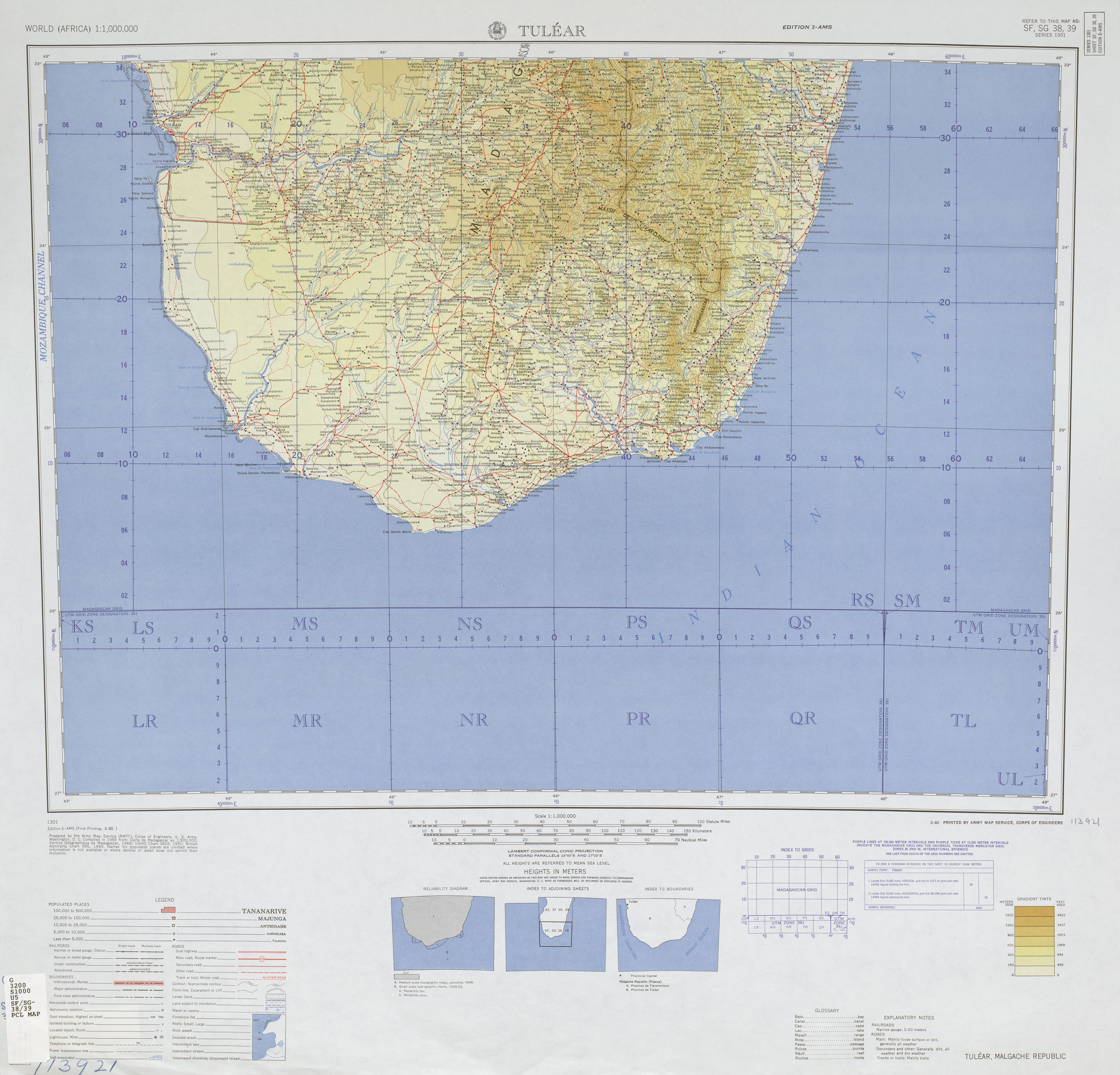
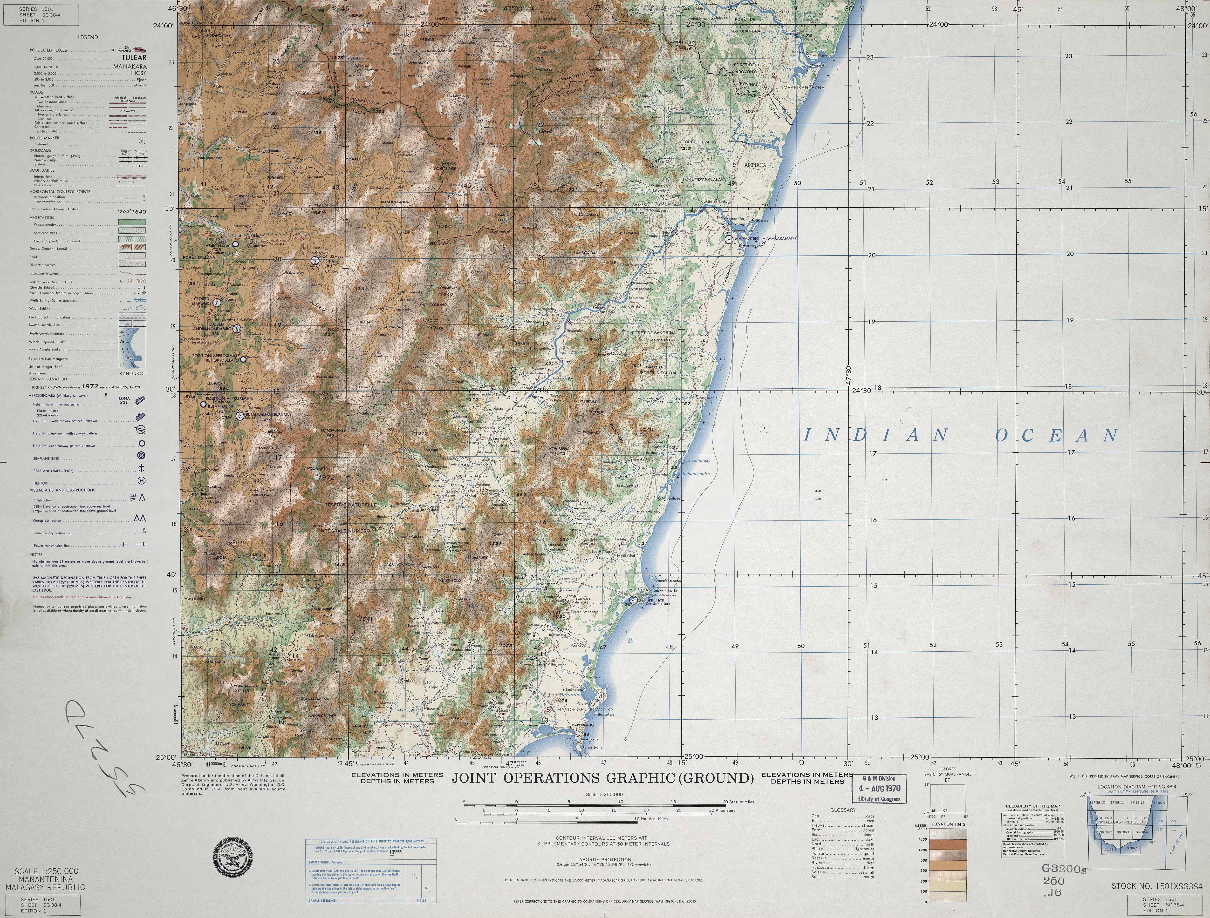
Anosy is a region in southeastern Madagascar, which covers 25,731km2 (9,935sqmi).[1] It borders Androy region to the southwest, across the Mandrare River. To the west is Atsimo-Andrefana, to the north is Ihorombe region, and to the northeast is Atsimo-Atsinanana region. To the east and south is the Indian Ocean. The region is approximately 150 kilometres (93mi) wide along its coastline and extends roughly 250km (160mi) inland. Anosy's capital and most-populous city is Tôlanaro (formerly Fort Dauphin), located about halfway along the region's coast and 1,122km (697mi) south of the national capital of Antananarivo.[10]
Anosy means "island" or "islands" in Malagasy. It may have been named for the island in the Fanjahira river (now Efaho river) where the Zafiraminia first settled when they arrived in the 16th century. Another theory is that the name means "land of the islands" because of the many temporary islands created when the Efaho valley floods during the rainy season.
Along the ocean are coastal lagoons and about 50km (31mi) of sandy, rolling coastal hills that butt up against the Vohimana mountains. This mountain range dominates the area, terminating just outside Tôlanaro at Mount Bezavona (Pic St. Louis), which stands at 529 metres (1,736ft).
The interior bedrock is granite, with cordieritegneiss exposed where erosion had occurred along the coast. The sand dunes along the coast, which average 18m (59ft) in depth, have mineral deposits of ilmenite, zircon, rutile and monazite.
There are three primary hydrologic drainage areas in Anosy: the Mountain Zone, the Bedrock Plain, and the Coastal Sands. The Mountain Zone covers 30% of the total catchment area and is distinguished by steep slopes, rapid runoff, and clearly defined rivers. The Bedrock Plain has rolling hills with low relief and several large rivers. The Coastal Sands are dunes at the ocean's edge cut with meandering rivers, ribbon lakes, and a series of lagoons and bays which vary in size from a few to two dozen square kilometres. The Coastal Sands can be further subdivided into the Andriambe, Ebakika, Efaho, Fanjahira, Lakandava, Lanirano, Manampanihy, Mandromodromotra, Vatomena, Vatomirindry and Vatorendrika basins.
There are three major rivers in Anosy: the Mandrare River along the southwestern border, the Efaho (formerly called the Fanjahira) just west of Tôlanaro, and the Manampanihy which drains the Ranomafana valley, emptying into the ocean at Manantenina.[6] Other rivers in the Anosy region include the Isoanala, Manambolo, Mangoky, Menarandra and Isoanala.
Climate
The average temperature in Tôlanaro ranges from 26°C (79°F) in January–February to 20°C (68°F) in July, with ocean temperatures ranging from 25°C (77°F) in January–February to 19°C (66°F) in June–July. The humidity of Tôlanaro ranges from 77 to 84 percent. Rainfall is highest on the eastern side of the mountains. In general, Anosy is very wet and humid in the northeast and becomes increasingly arid as one moves southwest.
Tôlanaro receives 1,800 millimetres (71in) of annual rainfall. Monthly precipitation is about 150mm (5.9in) in November through March, 190mm (7.5in)) in April, and less than 100mm (3.9in) for September and October. Tôlanaro is a windy town, with Force6 winds (39–49km/h[24–30mph]) for 6 to 13 days per month, August through November.[11][5][12][13][14] The region is occasionally damaged by cyclones, such as Cyclone Deborah in 1975, Cyclone Daisy in 1994, and Cyclone Gretelle in 1997.
Other protected areas include part of Kalambatritra Reserve. In 1996, Anosy was recognized[by whom?] as one of the most ecologically diverse regions of Madagascar.[citation needed] In 2014, Tôlanaro's coast was identified as seriously threatened due to "rise in sea level, landslides, and coastal erosion".[18]:148
Demographics
The region had a population of 809,313 in 2018.[2] At its present growth rate, it is expected to double its population in 15 years. The region is administratively divided into three districts; population densities are 52 inhabitants per square kilometre (130/sqmi) in the Tôlanaro District, 21/km2 (54/sqmi) in the Amboasary Atsimo District, and 14/km2 (36/sqmi) in the Betroka District.
The people who have historically lived in Anosy are known as the Antanosy people.[19] They may be more accurately described as "those from Anosy" given the region's history. The Antanosy live primarily in the east, along the coast and coastal rivers. There are also Antandroy living in the southwest, especially in the Tôlanaro District and in the Amboasary-Sud District, along with other Malagasy people from other parts of Madagascar. The rural interior Betroka District is chiefly inhabited by Bara people. There are also Asians who own many shops in urban centres and Europeans working in conservation, mining, tourism or for the Catholic Church. While there had been many French nationals living in Anosy during the French occupation of Madagascar, most had left by the mid-1970s.
Most of the people who live in Anosy are very poor, with an estimated GDP per capita in 2004 of just $180,[clarification needed] when the national average was $210. Eighty percent of its inhabitants don't have access to clean water, one in six suffer from serious respiratory illness, literacy is less than 20%, and 65% of the watershed slopes are highly degraded.[4]
As of 1997–98, literacy at the primary level in Anosy was 22% for boys and 23% for girls. Literacy was below 20% in some rural areas.
Of the 109 public primary schools in the Tôlanaro district in 1997–98, the average class size was 42 students per teacher. For secondary education, there were 5 CEGs (college of general education) and 1 lycée. The Amboasary district had 73 primary schools and 4 CEGs, while rural Anosy has few schools in a good state of repair.[26]
Healthcare is a challenge, as 80% of the population doesn't have access to clean water. In 2010, WHO/UNICEF estimated that only 1 in 10 Malagasy had access to improved sanitation facilities, resulting in high child mortality. 40% of children in rural areas die before age 5.[27]
Tôlanaro is serviced by Air Madagascar, with daily flights to and from the national capital, Antananarivo.
Only 50% of roadways in Anosy were passable in 2009. Many roads are closed during the rainy season, and four-wheel drive is recommended.[by whom?] A paved road was built connecting Tôlanaro–Amboasary–Ambovombe, but most of the surface has been wrecked. Some road repairs have been conducted with loans from the World Bank, and by international companies seeking access to the region's natural resources.
Buses run both north and west from Tôlanaro. Many are overcrowded and in poor repair, and some are simply trucks with metal benches.[citation needed]
Ehoala Port, opened in 2009, has greatly improved Anosy's shipping, and was developed for export of ilmenite (see mining, below). The historic harbour of Tôlanaro, about 10km (6.2mi) away, was known for a large number of ships which ran aground.
The only towns in Anosy with electrical power grids are Tôlanaro and Amboasary. The growth of Tôlanaro and poor condition of its generators resulted in mining firm QIT Madagascar Minerals (QMM) assuming responsibility for production of the town's electricity.
As of 2008, rural electrification in Anosy Region was only 7%. While a program entitled PEPSE Anosy was proposed to provide electricity from wind generators to eight towns, as of 2008 there was no evidence that this project had begun.[28][29]
Subsistence farming is the primary source of income of most people living in Anosy. Where there is sufficient rainfall, rice is the primary food crop, though in most cases only one crop is grown per year. Cassava is a very important food crop for those who can't afford rice year-round, which includes most of the Malagasy in the region. Yields for most crops are low, primarily due to the traditional methods of farming.
Cash crops
The three major cash crops in the Anosy region are coffee (primarily from the Ranomafana area), rosy periwinkle (southwestern coast of Anosy and coast of Androy) and sisal (Amboasary area).
Malagasy rosy periwinkle was researched by Eli Lilly beginning in 1958 for its potential use in preserving insulin. This was unsuccessful, but chemotherapy agents were discovered which have been credited with increasing the survival rate for childhood leukemia.[30][31][32]
Sisal cultivation was tested in 1928 and intensive farming practices were begun in the 1950s, reaching peak production in the mid-1960s. The development of synthetic fibres has largely replaced it in the international market, but sisal remains an important export.[33][34]
Mining has been occurring in Anosy beginning with the export of mica in the early 1900s. Uranothorianite was mined from the 1950s to the mid-1960s, for several years being Madagascar's second-most valuable export. Sapphires were a major export in the early- to mid-1990s. More recently, QIT Madagascar Minerals (QMM), owned 80 percent by mining giant Rio Tinto Group and 20 percent by the Malagasy government, has mined and exported 750,000 tons per year of ilmenite, along with 40,000 tons per year of rutile and zircon. There are also major deposits of bauxite which might be developed in the future, and there has been ongoing exploration for uranium and rare earth minerals.[38][39][40]
While mining exports have provided income for the government, there has been some skepticism[41][by whom?][unreliable source?] of the benefits to the people in terms of services to the communities, disruption of traditional life, and environmental effects from open-pit mining and heavy-metal tailings.
Mica
Mica was discovered near Tranomaro in 1912, and can be found in crystalline schists from Tôlanaro to Ihosy. There were 50 different companies mining mica in 1947, but demand fell in 1963. The biggest mine is at Ampandandrava, about 250km (160mi) from Tôlanaro, which exported 1,000 tons of mica in 2010.[42][43][44]
Uranium ores
Uranothorianite is a rich and highly radioactive ore of uranium. It was discovered by French surveyors in Anosy in 1953, and considered of great importance by the French Atomic Energy Commission (CEA). The locals called the dense black rocks vatovy and used them as slingshot ammunition and fishing weights.[citation needed] The CEA established a mining centre at Ambatomika, digging small open-pit mines.[45] Between 1954 and 1963, almost 4,000 tonnes of uranothorianite was mined and exported to France. By 1964 this was Madagascar's second-most valuable export. In 1963, the original Ambindandrakemba mine was exhausted, and the centre was moved 40km (25mi) north to Betioky, near the Belafa ore body which was thought to have between 2,000 and 5,000 tons of uranothorianite. Mining ended in 1968, due to the degradation of equipment and the discovery of larger deposits in Gabon and Niger.
In 2005, the Malagasy government conducted aerial magnetic and radiometric surveys of the area, which found thorium and uranium deposits increased to the west. In 2007, drilling by the Canadian firm Pan African Mining Corporation found a site with "high-grade uranium mineralisation grading 4,329 ppm uranium", with deposits as deep as 60 metres. London-based Bekitoly Resources Ltd. acquired exploration rights which include eight of the historical open-pit deposits, and have conducted airborne radiometrics and hyperspectral surveys, ground radiometrics and magnetics, mapping, grab sampling, trenching and drilling. These activities identified numerous areas of interest, with uranium and thorium scintillometer readings of up to 26,257 and 43,215 ppm, respectively. They also discovered numerous rare-earth elements.[46][47][48][49][50][51][52][excessive citations]
Sapphires were first documented in Anosy by Étienne de Flacourt in 1658, and were described by a French geologist working in the mica mines near Tranomaro in the 1950s. High-quality blue sapphires of up to 35 carats (7.0g) were found near the village of Andranondambo in 1991, and in the mid-1990s briefly attracted a rush of almost 10,000 miners. A 2004 environmental impact study found the area "highly degraded" with threatened ecosystems.[6][93][94][95][96][97][98][99][100][101][excessive citations]
Tourmaline is a semi-precious gemstone which has been found near Ampasimainty, Ianakafy and Iankaroka, all south of Betroka. It has also been found near Behara and Tranomaro, which are both closer to Amboasary. A 7-centimetre (2.8in) tourmaline crystal found near Tranomaro was sold for US$2,250.[citation needed]
Unexploited mineral resources
Exploration studies have documented an estimated 100 million tons of bauxite (an aluminium ore) in a 40-square-kilometre (15sqmi) area near Manantenina, 100km (62mi) north of Tôlanaro. It has not yet been mined, largely due to a lack of infrastructure in the area.[102][103][104][105]
There are an estimated 310,000 tons of monazite, a reddish-brown phosphate mineral which contains rare earth metals, in the beach sands near Tôlanaro.[106]
Anosy has a high potential for tourism with its pleasant climate, sprawling beaches, and nature reserves with distinctive wildlife (several containing lemurs). Tôlanaro has a variety of hotels and has promoted itself as the "Malagasy Riviera" (French: la cote d'Azur Malgache). As with other industries, tourism has been limited by a lack of infrastructure. Popular places to visit include Evatraha, Libanona beach, Lokaro, Manafiafy, Nahampoana and Vinanibe.[107][108] There are a variety of tourist agencies in Antananarivo[109][110][111][112][113][114] and Tôlanaro.[115][116][excessive citations]
The early history of Anosy is based primarily on archeological digs in the Efaho valley, just west of Tôlanaro. These 11th–13th century sites on the coastal dunes were small (0.5ha[1.2 acres] in size) and seasonal or temporary, based on the need to move to find food. Activities focused on fishing, cultivation of tubers and hunting. Iron working was also present.[citation needed] Trade was limited to the northeast, along the coast, and formed a very simple economic and social system.[117]
Evidence suggests that between the 13th and 15th centuries, those living in Anosy were working chlorite schist which was exchanged through the trade network for Chinese greenware pottery.[citation needed] A Chinese nautical map from 1315 shows Madagascar's coastline, winds and currents.[citation needed] Settlements grew slightly, primarily located on the flood plains and coastal lagoons, with cultivation of sweet potatoes and further development of iron working.[117] In the early 14th century, a Gujarat ship wrecked off the Anosy coast; it has been theorized that the stranded Gujarati went north to found the Zarabehava dynasty of Antesaka,[citation needed] though some scholars disagree.[118]:857
Zafiraminia dynasty
In the 16th century, the Zafiraminia (descendants of the Muslim Ramini) arrived in present-day Anosy and moved into the Efaho valley after being defeated by the Antambahoaka people to the north.[119] The Zafiraminia had lived in Madagascar from about the 13th century and had assimilated into the Malagasy population; they did not have Islamic institutions though they retained Arabic script and several socio-religious practices.[citation needed] The Zafiraminia introduced the use of wooden huts, owning cattle as a sign of wealth, and established a dynasty that lasted 200 years.[118]:857
The Zafiraminia established a stratified society with elaborate rituals, aided by their literacy, which was viewed as a kind of magic.[120][121] Their settlements were further inland, 2 to 7.5ha (5 to 19 acres) in size, and may have been fortified with ditches and wooden palisades.[citation needed]
European contact and Jesuit mission
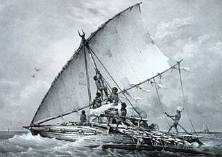
While the Zafiraminia moved into Anosy from the north, Europeans began arriving from the south. On 10 August 1500, a Portuguese crew – whose ship had been separated from the 2nd Portuguese India Armada during a storm – became the first Europeans to see Madagascar, at the southern coast near present-day Tôlanaro. They named it Ilha de São Lourenço ("Saint-Laurent" in French).[citation needed] There were at least five shipwrecks on this coast between 1504 and 1507, and historian Mike Pearson believes some of the Portuguese survivors built the fort Tranovato (English: house of stone), a 10-metre-square (33ft) stone blockhouse located on a hill 9km (5.6mi) west of present-day Tôlanaro.[122] Others believe it was erected a generation later, but it is likely the first European building on Madagascar, and sheltered shipwrecked sailors awaiting rescue.[123][124] Other shipwrecked sailors were able to assimilate, possibly aided by being light-skinned like the ruling Zafiraminia who claimed to be descended from Arabs.[citation needed] On 4August 1508, Diogo Lopes de Sequeira arrived on a Portuguese trade mission, recovering two shipwreck survivors who served as a Malagasy translators for contact and resupply. Trading colonies were attempted by the Portuguese and the French, but initial efforts were short-lived and abandoned. Shipwrecks continued and conditions at Anosy led cartographer Jean Parmentier to describe the waters as "the ocean without reason".[citation needed]
In 1613, a Portuguese expedition to Madagascar visited the stone fort at Travovato, which was occupied by a local king, Chambanga.[125] A treaty of friendship was agreed, trade was opened, and a church was built for Jesuit missionaries to begin evangelism. A dispute broke out when the king apparently reneged on an agreement to send his son Drian-Ramaka to Goa for Catholic education; the sailors seized the boy by force and their ship was briefly attacked before sailing to Goa. In April1616 the Jesuits returned to Anosy to exchange Drian-Ramaka for Chambanga's other sons, which the king refused; following accusations, and realizing their missionary work was in jeopardy, the Jesuits settled for a distant relation of the king.[124] Chambanga became further distrustful when the Portuguese began prospecting for gold and silver; he suspended trade, attempting to starve them out of Anosy. This continued when Drian-Ramaka succeeded his father, and respected the folk religion instead of embracing Catholicism. Suffering in isolation and having baptized only one Malagasy person over a year, the Jesuits left Anosy in 1617.[126]
Beginning in 1604, French King Henry IV began sending ships to Madagascar to compete with the Dutch colonies at the Gold Coast of Africa.[citation needed] In 1642, Cardinal Richelieu sought possession of Madagascar for France, granting trading rights to Captain Rigault and associates who created the first French East India Company. A French settlement was established at Manafiafy in Anosy. There were many deaths in the first months, likely due to malaria and dysentery in the swampy area, and the settlement was moved 40km (25mi) southwest to the peninsula of Taolanara where they built what was later named Fort Dauphin, France's first colony in the Indian Ocean. The site was 46 metres (150ft) above sea level, and with a redoubt built across the peninsula was defensible from sea and land.[127]
The French found Dian Ramaka to be friendly; their settlement sites were at the edge of the Zafiraminia's world and did not cause an affront. Sieur Jacques de Pronis, the first governor of the French East India Company, married a Zafindraminia noblewoman. However, Pronis angered the colonists who put him in chains; following his rescue, the rebels – both French and Malagasy – were banished to Réunion Island. Étienne de Flacourt took over as governor, and sought to establish several colonies in Madagascar to resupply European ships travelling to the Indies, obtaining food from the Malagasy through trade or by force, and selling indigo, tobacco and sugarcane to fund colonial expansion. By this time, rice and cattle had become the primary food sources. According to historian R.K. Kent, Anosy was one of the most-densely populated parts of Madagascar with considerable agricultural surpluses.[118] The Malagasy traded for ceramics from China, England, France and Portugal.[117]
Successive governors of Fort Dauphin in the mid-17th century sought to conquer Anosy by wresting control from the Zafiraminia kings, who had united under Dian Ramack (and later, his son Andriampanolahy). Several military campaigns pillaged and burned villages, killed and enslaved Malagasy, and stole tens of thousands of cattle. The Malagasy made reprisals with massacres, poisonings, and captured and burned Fort Dauphin. During the same period, missionary work was conducted by the Lazarist Congregation of the Mission. In 1674, after the French East India Company had twice been reorganized due to poor profits, the rebuilt Fort Dauphin was evacuated and the colony abandoned. The colonial failure was a bitter experience for the French, who left behind as many as 4,000 French casualties, and was a source of political embarrassment for 200 years.[citation needed]
Feudal rule
Conflict continued in Anosy following the French evacuation. When shipwrecked pirates took shelter at Fort Dauphin in 1697, their leader, Abraham Samuel, a mulatto from Martinique, was installed as a king. Until his death in 1705, Samuel led pirate–Anosy forces in constant warfare with Antanosy king Diamarang Diamera.[citation needed] The Zafiraminia also attempted to regain control, without success; they faced a number of revolts. The number and size of settlements shrank, and moved further inland.[117]
Frenchman Louis Laurent de Maudave[fr] arrived to rebuild Fort Dauphin as a supply base in 1768. He found that there were 35 rulers in Anosy, many of whom were at war with one another, and none of whom governed more than 3,000 people. He signed 30 treaties with local kings, making alliances by supplying them with muskets (over 10,000 muskets and 50 tons of gunpowder were sold).[citation needed] However, the French government abolished the French East India Company the following year, and Maudave's trading settlement was abandoned. At about the time of the French departure, the Zafiriminia kingdom also fell, having been ravaged by warfare since the mid-1600s.[citation needed]
In 1819, the French again reopened Fort Dauphin, after negotiating with the Zafiraminia chief Rabefania.[citation needed] The chief sought French protection from the Imerina Kingdom which was seeking to conquer the whole of Madagascar. Fort Dauphin continued to export cattle, and also became a slaving base and operated a rum distillery.
Imerina control
An army of the Imerina Kingdom of central Madagascar, numbering 3,000–4,000 soldiers, moved down the coast of Anosy and took Fort Dauphin on 14March 1825, at which point the Imerina Kingdom controlled the entire eastern coast of Madagascar.[citation needed] The fort was garrisoned by 800 Imerina troops armed with muskets which, along with garrisons at other coastal towns, controlled shipping trade. Most of Anosy, however, resisted the brutal treatment by the Imerina and was effectively self-ruled. The Imerina pursued a policy of isolationism and dismantled treaties with England and France.[citation needed]
Successive Imerina monarchs were alternately influenced by the French and English. In 1869, Imerina Queen Ranavalona II converted to Christianity. A church was built at Fort Dauphin and attendance made mandatory. Evangelists from the London Missionary Society later took leadership of the church.[citation needed]
France invaded Madagascar in 1883, to counter the growing British influence in the Indian Ocean. This first Madagascar expedition concerned itself mainly with the north of Madagascar, where Imerina power was centred. This created an opportunity for the Antanosy to revolt and seize Fort Dauphin, though the Imerina reclaimed it in 1884. In 1885, the fort was bombarded by a French warship and evacuated.[citation needed]
In 1887–88, Norwegian missionary Nielsen-Lund described the Antanosy population as "very scattered" and ruled by 30 feudal kings, and that northern Anosy was a lawless place. A Lutheran church and school was established outside Fort Dauphin, but the support given by the Queen of Imerina caused the missionaries to be viewed as collaborators by the Antanosy. In the following years, additional churches were established at Evatraha, Mandromondromotry, and Mahatalaky.[128][129] In 1891, natural rubber was discovered in western Anosy, and within a year 1,680 tons were exported.[citation needed]
The strategic importance of Madagascar had declined following the opening of the Suez Canal. Britain and France redefined their spheres of influence in Africa; Britain gained control of Zanzibar in return for recognizing Madagascar as a French protectorate. The French then launched the second Madagascar expedition in 1894. Again, the invaders concerned themselves mainly with the Imerina strongholds, and conquered north and central Madagascar in 1895. In Anosy, the Antandroy overran a number of European trading stations, forcing the foreigners out and plundering their stores.[citation needed]
Madagascar officially became a French colony on 6August 1896, and French troops took control of Fort Dauphin. Europeans reported a great deal of insecurity elsewhere in southern Madagascar. The interior of Anosy was ruled by Antanosy king Rabefagnatrika, who was a rival of pro-French Manambaro king Rabefially. Southern Madagascar was conquered by the French in 1898, using counter-insurgency methods developed in Indochina.
In 1897, the French governor reintroduced the Imerina labour tax, requiring every able-bodied male to provide 50 days of unpaid labour per year. Head taxes were also imposed, under penalty of forced labour, in efforts to increase agricultural production and tax revenues. Roads were built and plantations established for European companies and settlers. Many villages were relocated along the new highways. Activities of Roman Catholic and Lutheran missionaries increased.
The harsh regime and disregard for Malagasy culture were met by a number of small revolts and raids, which culminated in a general uprising in 1904–1905. While the uprising was sparked in the north, the southeast had become fertile ground for revolution. Antanosy king king Befanatrika led rebels south into Anosy, and in December 1904 captured Esira, Fort Dauphin, and Manambaro, with widespread looting.[130] While Protestants generally supported the uprising, Catholics opposed it and a number of Catholic churches were burned by the rebels.[131] Following the revolt, the French closed the Lutheran schools and churches, believing them complicit. The region also suffered from smallpox and locusts during this time.[citation needed]
In 1926–27, the head tax was almost doubled and a three-year conscription system instituted to provide more labour for colony construction projects.[citation needed] The government also continued to seize lands for these projects, plantations, and French settlers.
During World WarII, Madagascar was the site of a 1942 campaign between Allied and Vichy French forces. The fighting was concentrated in the north and central regions; the Vichy governor-general had retreated steadily southward, and surrendered rather than enter Anosy. These incidents and the British occupation further tarnished the prestige of the French colonial government. Nationalist and pro-independence sentiments strengthened following the return of men forced into conscription, the continuation of forced labour, and the absence of reforms promised by Charles de Gaulle. When the French government refused to support a democratic process toward Madagascar independence, militant independence leaders gained ground and initiated the Malagasy Uprising (1947–1949).
The uprising began in the east and was immediately followed by the south where it enjoyed particularly strong support and attracted as many as one million peasants to fight.[132]:207 The southern rebels were led by Betsileo former-teacher Michel Radaoroson.[133]:83 His leadership was usurped in August 1947 by Lehoaha, whose insurgents were better armed.[133]:84 The intensity and cruelty of the French response was unprecedented in French colonial history,[134] and military records of the conflict were classified.[135]
Madagascar gained independence by referendum in 1958. Political power of the new government was consolidated amongst the Imerina middle-class, and was challenged in 1971 by a peasant uprising in Toliara Province (which includes the present Anosy Region). Sisal production in Anosy peaked in 1964 but rapidly declined thereafter. Periwinkle plantations began, as did exports of seaweed to Japan and live lobsters to Europe.
Student protests joined by a general strike and rioting led to a state of emergency, a military government fraught with ethnic coups, and the 1975 establishment of the Democratic Republic of Madagascar. This second republic pursued socialist reforms with the aims of achieving rapid economic and cultural development. In the 1980s, the rapid growth of Tôlanaro created deforestation in Anosy, which became a high-priority area for international conservation efforts. The World Wildlife Fund began working in Andohahela National Park. Meanwhile, QIT-Fer et Titane established an office in Tôlanaro and began a joint venture to mine ilmenite.
Politically weakened by the dissolution of the Soviet Union, the socialist regime transitioned to the Third Republic of Madagascar in 1992. Ecotourism in Anosy grew rapidly in the early and mid-1990s, but temporarily collapsed during 2007–2009 due to the complete booking of Tôlanaro hotels for QMM employees and contractors.[citation needed] UK-based charity Azafady began poverty-relief efforts in southeast Madagascar in 1994. Tôlanaro suffered a cholera outbreak in 2000–2001 and syphilis outbreak in 2007, the later resulting in a state of emergency.[136] The World Bank named the town as one of three sites for its Integrated Growth Poles project.[137]Port d'Ehola is completed in 2009, enabling QMM to export Ilmenite to Canada.[53] In 2011, QMM takes over electricity production for Tôlanaro. Vigilantism rises in Anosy in response to banditry, with over 100 extralegal executions in 2012.[citation needed]
Further reading
Jolly, Allison (2004). Lords and Lemurs: Mad Scientists, Kings With Spears, and the Survival of Diversity in Madagascar. Portland: Book News.
Verstraeten, I.M. & Mihalasky, F.I. (2006). Monograph on a Study of the Future Impact of Minerals, Hydrology, and Ecology on Integrated Regional Economic Development in the Anosy Region, Madagascar. U.S. Geological Survey Administrative Proprietary Report. Submitted to the Projet de Gouvernance des Ressources Minérales (PGRM), Madagascar and to the World Bank, Reston, Virginia, 551 p. (also published separately in French).
Ingram, J.C. (2004). Questioning simplistic representations of environmental change in southeastern Madagascar: An assessment of forest change, condition and diversity of littoral forests. Conference paper presented at "Trees, rain and politics in Africa. The dynamics and politics of climatic and environmental change. 29th Sept - 1st Oct, 2004. St Antony's College Oxford.
Ranivoarivelo Lantoasinoro Nirinarisoa. (2007). Essai d’élevage lagunaire de crevette Peneide( Penaeus monodon) dans la region d’Anosy. Exemple de la lagune d’Ambinanibe (Tolagnaro). IH.SM –Universite de Toliara – USAID
Burgess, Andrew. (1932). Zanahary in south Madagascar. Minneapolis: Board of Foreign Missions.
Congrégation de la Mission (Lazaristes) (Ed.). (1996). Le Christianisme dans le sud de Madagascar. Mélanges à l'occasion du centenaire de la reprise de l'évangélisation du sud de Madagascar par la congrégation de la Mission (Lazaristes) 1896–1996. Fianarantsoa: Editions Ambozontany. [history of Christianity in South Madagascar with chapter on history of American Lutheran missions in the South (1887–1950) by Dr. James B. Vigen, other chapters regarding history of different Catholic congregations and "Bilan du Christianisme dans le Sud de Madagascar" by Mgr Rakotondravahatra, Jean-Guy which describes current context, state and challenges of Christianity in South Madagascar.]
Rakotoarisoa, Jean-Aimé. (1994). Le peuplement de l’Anosy. Les rapports de l’homme et son environment dans l’extreme sud-est de Madagascar, Thése de l’Institut National des Langues et Civilisations Orientale, Paris.
"Site web FTM". ftm.mg. Archived from the original on 2011-11-14. Retrieved 2011-10-08. including maps No. 12 Tôlanaro (eastern coast north of Tôlanaro) and No. 11 Ampanihy (which is actually a map of southern Madagascar, from Tôlanaro across to Toliary).
The history of Madagascar is distinguished clearly by the early isolation of the landmass from the ancient supercontinent containing Africa and India, and by the island's late colonization by human settlers arriving in outrigger canoes from the Sunda islands and from East Africa. These two factors facilitated the evolution and survival of thousands of endemic plant and animal species, some of which have gone extinct or are currently threatened with extinction due to the government not allocating resources to help the growing population, causing many people to resort to harmful environmental practices as a way of survival. Over the past two thousand years the island has received waves of settlers of diverse origins including Austronesian, Bantu, Arab, South Asian, Chinese and European. The majority of the population of Madagascar today is a mixture of Austronesian and Bantu settlers. Despite popular belief, there has been no genetic input from Arabs or Indians, although one tribe, the Antemoro, claims descent from Somali Arab traders.
The economy of Madagascar is a market economy and is supported by Madagascar's well-established agricultural industry and emerging tourism, textile and mining industries. Malagasy agriculture produces tropical staple crops such as rice and cassava, as well as cash crops such as vanilla and coffee. Madagascar's wealth of natural resources supports its sizable mining industry. Additionally, Madagascar's status as a developing nation exempts Malagasy exports from customs protocol in some areas, notably the United States and European Union. These exemptions have supported the growth of the Malagasy textile industry. Despite Madagascar's natural resources and developing industries, the 2009 Malagasy political crisis—considered by the international community to be an illegal coup—deterred foreign investments in Madagascar and caused the Malagasy economy to decline. Foreign investments have resumed following the resumption of elections in early 2014. At 2018, Madagascar is one of the world's fastest-growing economies.
Antananarivo, also known by its colonial shorthand form Tana, is the capital and largest city of Madagascar. The administrative area of the city, known as Antananarivo-Renivohitra, is the capital of Analamanga region. The city sits at 1,280 m (4,199 ft) above sea level in the center of the island, the highest national capital by elevation among the island countries. It has been the country's largest population center since at least the 18th century. The presidency, National Assembly, Senate and Supreme Court are located there, as are 21 diplomatic missions and the headquarters of many national and international businesses and NGOs. It has more universities, nightclubs, art venues, and medical services than any city on the island. Several national and local sports teams, including the championship-winning national rugby team, the Makis are based here.
Jean-Joseph Rabearivelo, born Joseph-Casimir Rabearivelo, is widely considered to be Africa's first modern poet and the greatest literary artist of Madagascar. Part of the first generation raised under French colonization, Rabearivelo grew up impoverished and failed to complete secondary education. His passion for French literature and traditional Malagasy poetry (ohabolana) prompted him to read extensively and educate himself on a variety of subjects, including the French language and its poetic and prose traditions. He published his first poems as an adolescent in local literary reviews, soon obtaining employment at a publishing house where he worked as a proofreader and editor of its literary journals. He published numerous poetry anthologies in French and Malagasy as well as literary critiques, an opera, and two novels.
Tôlanaro or Tolagnaro is a city on the southeast coast of Madagascar. It is the capital of the Anosy Region and of the Tôlanaro District. It has been a port of local importance since the early 1500s, and a new port, the Ehoala Port, has been built by QMM and the World Bank. Formerly Fort-Dauphin, it was the first French settlement in Madagascar.
Toliara is a city in Madagascar.
Androy is the most southerly region of Madagascar. It covers an area of 19,540 km2, and had a population of 903,376 inhabitants in 2018. The administrative capital is Ambovombe-Androy, and the chief administrator is Michael Andrianirina.
The Roman Catholic Diocese of Tôla(g)naro is a Latin suffragan diocese in the Ecclesiastical province of Toliara in Madagascar, yet still depends on the missionary Roman Congregation for the Evangelization of Peoples.
Ihorombe is a region in Madagascar. It borders Haute Matsiatra region in north, Atsimo-Atsinanana in east, Anosy in south and Atsimo-Andrefana in west. The capital is Ihosy and the population was 418,520 in 2018. The area of Ihorombe is 26,391 km2 (10,190 sq mi) and it has one of the lowest population densities of the Malagasy regions.
Andriana refers to both the noble class and a title of nobility in Madagascar. Historically, many Malagasy ethnic groups lived in highly stratified caste-based social orders in which the andriana were the highest strata. They were above the Hova and Andevo (slaves). The Andriana and the Hova were a part of Fotsy, while the Andevo were Mainty in local terminology.
QIT Madagascar Minerals (QMM) is a mining company located in the Fort-Dauphin region of southeastern Madagascar. After roughly 20 years of exploration, negotiations, and preliminary work, the company began production of the titanium dioxide ore, ilmenite. Initial capacity is projected at 750,000 tonnes per year, with future phases of development potentially expanding capacity to 2,000,000 tonnes per year. The mine is 80% owned by QIT-Fer et Titane, a wholly owned subsidiary of the mining giant Rio Tinto Group; the remaining 20% is owned by the government of Madagascar.
Malagasy is an Austronesian language and the national language of Madagascar. Most people in Madagascar speak it as a first language, as do some people of Malagasy descent elsewhere.
The Antanosy is a Malagasy ethnic group who primarily live in the Anosy region of southeastern Madagascar, though there are also Antanosy living near Bezaha, where some of the Antanosy moved after the Merina people conquered Anosy. An estimated 360,000 people identify as Antanosy as of 2013.
Abraham Samuel, also known as "Tolinar Rex," born in Martinique, was a mulatto pirate of the Indian Ocean in the days of the Pirate Round in the late-1690s. Being shipwrecked on his way back to New York, he briefly led a combined pirate-Antanosy kingdom from Fort Dauphin, Madagascar, from 1697 until he died there in 1705.
Amboasary Sud is a town in Anosy Region, Madagascar. It is the main town of Amboasary District.
The Port d'Ehola is a port in southern Madagascar at approx. 10 km from the city of Tôlanaro (Fort-Dauphin).
Route nationale 13 is a primary highway in Madagascar of 493 km, running from Ihosy to Tolagnaro (Fort-Dauphin). It crosses the regions of Ihorombe, Androy and Anosy.
Lycée Privé La Clairefontaine, also known as the Collège La Clairefontaine or the École La Clairefontaine, is a private French international school, serving preschool through senior high school, with campuses in the Antananarivo area and in Tôlanaro (Fort-Dauphin) in Madagascar.
1 2 Di Boscio, N. (2010, March). Mining enterprises and regional economic development: An exploratory analysis of the sustainable development model. PhD Dissertation. London School of Economics and Political Science.
↑ Verstraeten, I.M. & Mihalasky, F.I. (2006). Monograph on a Study of the Future Impact of Minerals, Hydrology, and Ecology on Integrated Regional Economic Development in the Anosy Region, Madagascar. U.S. Geological Survey Administrative Proprietary Report. Submitted to the Projet de Gouvernance des Ressources Minérales (PGRM), Madagascar and to the World Bank, Reston, Virginia, 551 p. (also published separately in French).
↑ Institut National de la Statistique, Antananarivo.
↑ Ratsivalaka-Randriamanga, Simone. (1989). Le climat de Fort Dauphin et son impact sur l'homme et la vegetation. These de Doctorat de IIIe cycle, Antananarivo: Dept de Geographie, L"Universite d'Antananarivo.
↑ Ingram, J.C. (2004). Questioning simplistic representations of environmental change in southeastern Madagascar: An assessment of forest change, condition and diversity of littoral forests. Conference paper presented at "Trees, rain and politics in Africa. The dynamics and politics of climatic and environmental change. 29th Sept - 1st Oct, 2004. St Antony's College Oxford.
↑ Rahobisoa, J.-J., Rambolamanana Ratrimo, V. & Ranaivoarisoa, A. (2014). Mitigating coastal erosion in Fort Dauphin, Madagascar. In Kaneko, N., Yoshiura, S. & Kobayashi, M. (Eds.), Sustainable living with environmental risks, (pp. 147-166). New York: Springer Open.
↑ Congrégation de la Mission (Lazaristes) (Ed.). (1996). Le Christianisme dans le sud de Madagascar. Mélanges à l'occasion du centenaire de la reprise de l'évangélisation du sud de Madagascar par la congrégation de la Mission (Lazaristes) 1896–1996. Fianarantsoa: Editions Ambozontany. [history of Christianity in South Madagascar with chapter on history of American Lutheran missions in the South (1887–1950) by Dr. James B. Vigen, other chapters regarding history of different Catholic congregations and "Bilan du Christianisme dans le Sud de Madagascar" by Mgr Rakotondravahatra, Jean-Guy which describes current context, state and challenges of Christianity in South Madagascar.]
↑ Ranivoarivelo Lantoasinoro Nirinarisoa. (2007). Essai d’élevage lagunaire de crevette Peneide( Penaeus monodon) dans la region d’Anosy. Exemple de la lagune d’Ambinanibe (Tolagnaro). IH.SM –Universite de Toliara – USAID
↑ Mihalasky, M.J., Peters, S.G., Carter, J., Dillingham, W.S., Dobbin, J., Hammarstrom, J.M., Lampietti, F.M.J., Mack, T.J., Sutphin, D.M., Verstraeten I.M. & Mihalasky, F.I. (2006). Anosy Region Dynamic Spatial Analysis GIS, Identification of Three Areas Having Future Mineral Potential & Summary of Socioeconomic Planning (Version 1.1e) (DVD-ROM). For the project Study of the Future Impact of Minerals, Hydrology & Ecology on the Integrated Economic Development in the Anosy Region, Madagascar. U.S. Geological Survey Administrative Report. The Projet de Gouvernance des Ressources Minérales and the World.
↑ Navalona, R. (2010, 9 July). Developpement de Taolagnaro: QMM investit plus d'Ar 200 millions pour realiser le programme 'Fagneva' cette annee. Midi Madagasikara.
↑ [permanent dead link] Monazite de Manantenina. Also see Montel, J.M. et al. (2011). Monazite from mountain to ocean: A case study from Trolognaro (Fort-Dauphin), Madagascar. European Journal of Mineralogy, 23(5), 745-757.
1 2 3 Kent, R.K. (1992). Madagascar and the islands of the Indian Ocean. In Ogot, B.A. (Ed.), General History of Africa-V: Africa from the Sixteenth to the Eighteenth century. Paris: UNESCO.
↑ Parker Pearson Mike (1997). "Close encounters of the worst kind: Malagasy resistance and colonial disasters in Southern Madagascar". World Archaeology. 28 (3): 393–417. doi:10.1080/00438243.1997.9980355.
↑ Vigen, James B. (1991). A historical and missiological account of the pioneer missionaries in the establishment of the American Lutheran mission in southeast Madagascar, 1887–1911: John P. and Oline Hogstad. Doctoral Dissertation. Lutheran School of Theology, Chicago.
↑ Mutibwa, Phares M. (1980). "Resistance to Colonialism: The Revolt of 1904—5 in South-East Madagascar". Transafrican Journal of History. 9 (1/2): 134–152. ISSN0251-0391. JSTOR24328554.
1 1975 is the year of East Timor's Declaration of Independence and subsequent invasion by Indonesia. In 2002, East Timor's independence was fully recognized.
This page is based on this Wikipedia article Text is available under the CC BY-SA 4.0 license; additional terms may apply. Images, videos and audio are available under their respective licenses.


